HGS RESEARCH HIGHLIGHT - Characterizing the climate-driven collapses and expansions of wetland habitat networks with HydroGeoSphere
AUTHORS: Ganming Liu, Franklin W. Schwartz, Christopher K. Wright, and Nancy E. McIntyre
The use of HydroGeoSphere (HGS) in assessing wetland habitat connectivity in this study presents a new direction in the application of such a sophisticated hydrologic model. The following paragraphs describe the background/motivation, some of the results, and implication of the study.
Habitat connectivity is a landscape attribute critical to preserving biodiversity in the face of climate change. It describes the ability of species to disperse or move between patches of suitable habitat. For wetland-dependent species, movements between wetlands involve a range of spatial scales, and involve activities such as foraging within wetland complexes, dispersal to newly available habitat during deluge, and migration to drought refugia during dry times. Such movements are critical to long-term persistence and will influence species range adjustments to climatic shifts.
There has been a recent emphasis on new strategies for describing and evaluating the quality of wetland habitat connectivity for wildlife. One of the most compelling approaches involves the application of graph theory to establish links between climatic drivers and habitat connectivity. The graph-theoretical approach treats wetlands as nodes to map habitat connectivity and to define habitat networks (figure below) for ecological analysis.
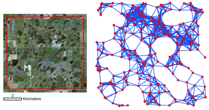
A wetland landscape in central North Dakota (left) and the associated network (right) created with a graph-theoretical approach. Circles represent nodes (i.e., centroids of wetlands) and lines represent links between nodes that have a distance less than a threshold value or disperse distance of 1000 m.
To apply the graph-theoretic approach to define wetland networks and to determine potential habitat connectivity across landscapes, the first and most essential step is to identify nodes on the landscapes, which requires spatially explicit information, e.g., X (longitude or UTM easting) and Y (latitude or UTM northing) values for wetland centroids. Satellite imagery has proven to be invaluable for this purpose by providing large-scale data-sets for monitoring the hydrologic character of wetlands and lakes and patterns of change. However, using these kinds of data come with certain limitations, for examples, the relatively short duration of observational records, their modest spatial resolutions, and the inability to provide direct quantitative information with respect to water transfers. Hydrologic models, such as HGS, can be used to leverage such satellite-based observations.
This study applied the HGS to simulate the hydrologic dynamics of wetlands in the Prairie Pothole Region (PPR) and to characterize the resulting habitat networks as a function of climate variability. Results show HGS was able to simulate water movement in both surface and subsurface domains and capture "fill-spill" and coalescence/disaggregation behaviors of wetlands as they responded to wet and dry climatic conditions. Our network analysis based on the HGS results illustrated broad differences in network connectivity, ranging from near total fragmentation of wetlands to strong ecological connectivity, as the climate varied from drought to deluge. In other words, wetland networks in the PPR could easily shrink, degrade, or even collapse when the climate becomes drier.
To the best of our knowledge, this study represents the first example where the results of the 3-D hydrologic modeling have been linked with graph theory to ascertain the effects of drought and deluge on ecological connectivity. This study obviously demonstrates the potential in applying the HGS model to solve critical ecological problems and the practical implications for water-resources management, conservation planning and decision-making in the PPR.