
HGS RESEARCH HIGHLIGHT – Using High-Resolution Data to Test Parameter Sensitivity of the Distributed Hydrological Model HydroGeoSphere
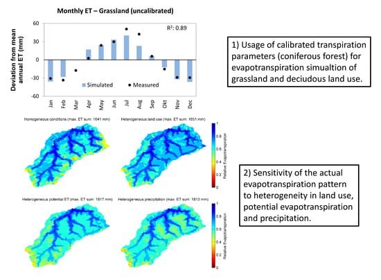
By integrating HydroGeoSphere in this study, the researchers demonstrate its versatility in accommodating high-resolution data and conducting sensitivity analyses across different spatial scales. Precipitation emerges as the most sensitive input data, significantly influencing total runoff and peak flow rates. Additionally, the study highlights the importance of spatially distributed land use parameterization in accurately simulating evapotranspiration components and patterns.
HGS RESEARCH HIGHLIGHT – Groundwaters in Northeastern Pennsylvania near intense hydraulic fracturing activities exhibit few organic chemical impacts
In this comprehensive study, researchers investigated the potential impact of hydraulic fracturing activities on groundwater quality in Northeastern Pennsylvania, using a HydroGeoSphere model of a region with thirty gas-well pads. Modelling results suggest a low probability of systematic groundwater organic contamination in the region.

HGS RESEARCH HIGHLIGHT – How Does Topography Control Topography-Driven Groundwater Flow?
In a study led by Xiaolang Zhang, Jiu Jimmy Jiao, Wensi Guo, researchers have comprehensively explored the mechanisms governing topography-driven groundwater flow. Their research showcases the complexities between varying rainfall patterns, topographic features, and groundwater flow dynamics, offering invaluable insights into hydrological processes.

HGS RESEARCH HIGHLIGHT – Comparing alternative conceptual models for tile drains and soil heterogeneity for the simulation of tile drainage in agricultural catchments
This research highlight explores tile drainage systems within agricultural catchments, with the goal of refining hydrological modeling methodologies. The study explores the impact of soil heterogeneity on model simulations, revealing its significance at smaller scales. Overall, offering valuable insights into improving the representation of tile drainage in hydrological models, crucial for sustainable water management in agricultural landscapes.

HGS RESEARCH HIGHLIGHT – The coastal aquifer recovery subject to storm surge: Effects of connected heterogeneity, physical barrier and surge frequency
This research analyzes the combined effects of connected heterogeneity, physical barriers, and surge frequency on coastal aquifer recovery. Using HydroGeoSphere (HGS), Aquanty’s sophisticated modeling platform known for its ability to simulate coupled surface water-groundwater interactions, the team investigated a series of modeling cases in heterogeneous and equivalent homogeneous aquifers.

HGS RESEARCH HIGHLIGHT – Fractal Behaviors of Hydraulic Head and Surface Runoff of the Nested Groundwater Flow Systems in Response to Rainfall Fluctuations
In this paper the authors have undertaken a comprehensive investigation into the behavior of nested groundwater flow systems (NGFS) in response to rainfall fluctuations and their influence on surface runoff. Through the utilization of a fully coupled variably saturated groundwater-surface water model alongside spectral analysis, the team delves into the fractal characteristics of hydraulic head and surface runoff across different scenarios.

HGS RESEARCH HIGHLIGHT – Saltwater Intrusion Into a Confined Island Aquifer Driven by Erosion, Changing Recharge, Sea-Level Rise, and Coastal Flooding
This research sheds light on the complex interactions between storm surges, reduced recharge, high erosion rates, and sea-level rise on the hydrological balance of Prince Edward Island. By leveraging the advanced capabilities of HGS, the researchers were able to test impact that climate change and future trends in coastal hydrology will have on the islands groundwater quality and the movement on the saltwater wedge underlying PEI.

HydroGeoSphere Research Paper wins Water Resources Research Editors’ Choice Award
We’d like to highlight a terrific achievement in the HydroGeoSphere user community, and send a hearty congratulations to Dr. James Thornton and his research team for winning the 2022 Editors’ Choice Award from the Water Resources Research journal.
HGS RESEARCH HIGHLIGHT – Simulating the recession dynamics of Arctic catchments in the context of a thawing permafrost
In a recent study, researchers have made significant strides in understanding how climate warming is altering the Arctic's hydrological dynamics. The study delves into the complex relationship between permafrost thaw and groundwater flow. Traditionally, Arctic hydrology has been conceptualized as a local system, confined by the frozen ground. However, as the climate warms, permafrost begins to thaw, transitioning this system into a more interconnected network of regional aquifers. This transformation is crucial, as it alters the fundamental dynamics of water movement and storage in the Arctic.

HGS RESEARCH HIGHLIGHT – Understanding the vulnerability of surface–groundwater interactions to climate change: insights from a Bavarian Forest headwater catchment
This study used HydroGeoSphere to evaluate the impact of climate change on streamflow and water availability within a small forested catchment in South-East Germany. Climate forecasts in the region predict a significant decrease in precipitation over the coming decades. Based on integrated hydrologic modelling of the catchment, this forecasted decline in precipitation combined with a relatively steady rate of evapotranspiration (compared to the historical period) will result in prolonged drought conditions, which in turn will result in declining groundwater levels, decreased baseflow to the upstream reaches of the stream network.