
HydroSphereAI Case Study: Crowe River Near Glen Alda
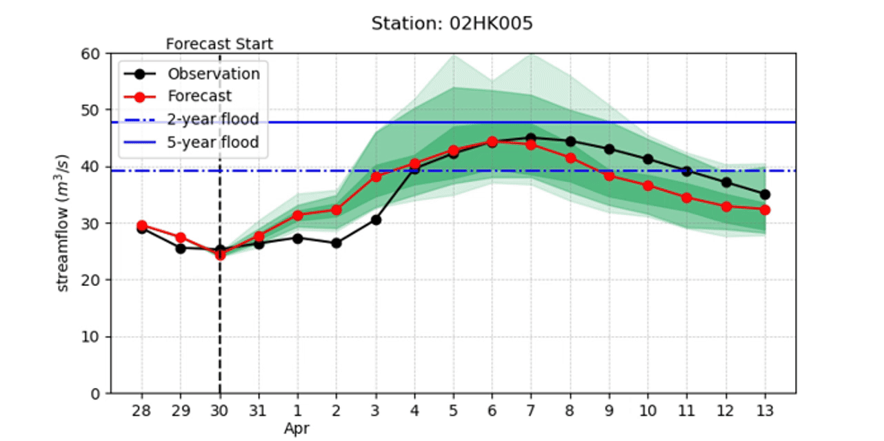
In late March 2025, the Crowe Valley Conservation Authority issued a Flood Watch across the watershed in response to a forecasted storm system and ongoing spring runoff. Forecasted rainfall, saturated soils, and an above-average snowpack created the right conditions for elevated streamflows, particularly in the Crowe River watershed. With a peak spring snow water equivalent (SWE) of 149.2 mm, the basin was primed for rapid hydrologic response—culminating in a strong single peak on April 6, when flows at Water Survey of Canada hydrometric Station 02HK005 reached 45.2 m³/s.

The Crowe Valley watershed in southern Ontario is located roughly between Toronto and Ottawa. Station 02HK005 is found on the Crowe River near the community of Glen Alda.
As the weather system approached, Aquanty’s HydroSphereAI (HSAI) machine learning-based streamflow forecasting platform tracked the developing conditions in real time. Forecasts issued in the days before April 6 consistently signaled an elevated risk of flooding. The event's peak surpassed the 2-year flood threshold (39.2 m³/s) and approached the 5-year flood marker of 47.8 m³/s, highlighting the hydrologic response to the incoming precipitation. While the forecasted median flow slightly underestimated the peak magnitude, the actual flow remained within the upper range of the ensemble spread— giving local users insight into not just when high flows might be observed, but how severe it could be.
Ensemble forecasts from March 31 onward captured the structure and timing of the rising limb well. As new weather information became available, HydroSphereAI adapted, narrowing its ensemble spread and adjusting its predictions closer to the observed value. By April 5, just a day before the peak, the forecast had improved significantly— offering a sharper signal that pointed directly to April 6 as the likely day of maximum discharge. This progression from early uncertainty to focused prediction is a strong example of how ensemble forecasts deliver value by showing both the expected outcome and the possible range of variation.
HydroSphereAI’s performance in this event reflects a common pattern in operational forecasting: early lead times tend to carry more uncertainty, particularly when weather inputs— like precipitation forecasts— are still evolving. In this case, early weather forecasts had conservative precipitation estimates around 20 mm/day, but those values climbed to over 25 mm/day as the storm approached. HSAI incorporated these updates dynamically. This highlights a key strength of the system— its ability to respond in real time to improved weather inputs, helping local authorities keep pace with fast-changing conditions. The platform currently uses Environment and Climate Change Canada’s 16-day GEPS ensemble forecasts but is also being expanded to draw from additional meteorological forecasting products to further improve responsiveness and flexibility (e.g. the HRDPS and HRRR short-range meteorological forecasts, with 48-hour forecast horizons and hourly timestep).
Snowmelt was not the dominant driver for this event, though the watershed did start the spring season with a significant snowpack. By early April, much of that snow had already contributed to baseflow increases. The April 6 peak was primarily a result of direct precipitation. Recognizing the shift from snowmelt to rainfall-driven events is critical in interpreting forecast outcomes accurately— and emphasizes the importance of real-time hydrologic modelling when assessing flood risk.
HydroSphereAI consistently highlighted April 6 as the key date of concern and captured the event’s scale within its probabilistic ensemble. This allowed users to prepare with confidence even in the face of some uncertainty in the predicted magnitude. Importantly, the utility of the forecast came not just from a single number, but from its structure— the ensemble design helped communicate risk in a way that was transparent, flexible and immediately actionable.
In the Crowe River watershed, HydroSphereAI once again demonstrated the power of real-time, ensemble-based forecasting to support decision-making. By clearly signaling high flows days ahead of the peak and adapting quickly to new data, the platform could give conservation staff and stakeholders a dynamic tool to track evolving conditions and respond accordingly. As climate variability continues to influence the timing and severity of spring flood events, tools like HydroSphereAI will become essential to anticipating flood hazards and managing response with data-driven insights.