

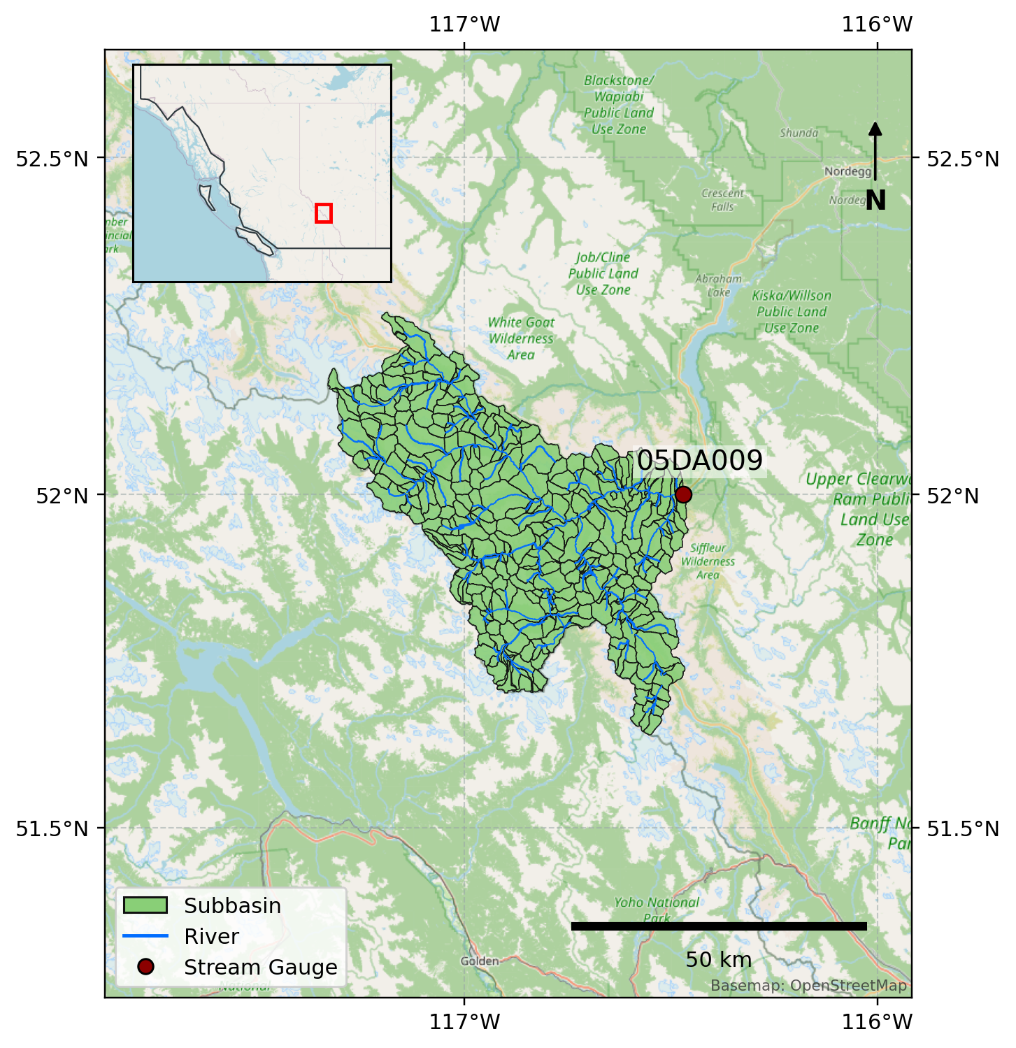
Delta-Models for Reservoir Operations – NORTH SASKATCHEWAN RIVER AT WHIRLPOOL POINT (05DA009)
The Bighorn dam is located in the foothills of the Canadian Rockies in Alberta and is one of TransAlta's major hydroelectric facilities, with a capacity of 120 MW and an average annual generation of approximately 408,000 MWh (Bighorn - TransAlta). Reservoir planning is important for hydropower operations because operators must balance water availability, storage constraints, generation demand, flood risk, and downstream flow requirements. In snowmelt dominated basins (like this one), reservoir inflow relies on both current streamflow and upstream watershed conditions which determine future water volumes over coming days, weeks, and months. These conditions include the amount of water stored as snowpack, the timing/rate of snowmelt, antecedent soil wetness, incoming precipitation, and changes in temperature.
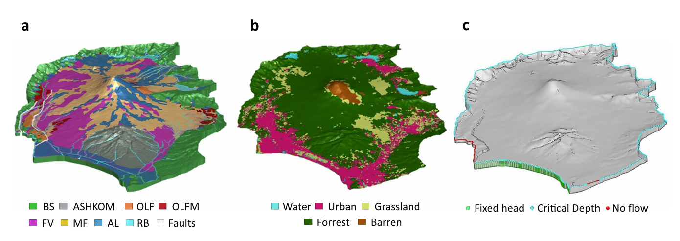
HGS RESEARCH HIGHLIGHT – Modeling a geologically complex volcanic watershed for integrated water resources management in Mt. Fuji, Japan
This publication presents a three-dimensional geological and integrated hydrological modelling dataset developed for the Mt. Fuji volcanic watershed in Japan. This study leverages HydroGeoSphere (HGS) to simulate coupled surface–subsurface flow and transport processes in a geologically complex volcanic catchment, addressing long-standing challenges in representing groundwater flow pathways and hydrologic interactions in structurally heterogeneous mountain environments. The resulting dataset provides a physically consistent modelling framework to support interdisciplinary water resources research and scenario-based hydrologic simulations.
Flee From Parsimony: Escaping the Boundary Condition Paradox in Groundwater Modelling - Aquanty Webinar
We’re pleased to share the recording of our recent webinar, Tracking Surface Water and Groundwater Contributions to Flooding in an Alluvial Aquifer. This session, presented by Dr. Michael Callaghan, Senior Applications Engineer at Aquanty Inc., explores how integrated hydrologic modelling can improve understanding of groundwater flooding risks— particularly during major flood events.
Focusing on the June 2013 flooding in southern Alberta, the webinar demonstrates how groundwater flow within alluvial aquifers can contribute to infrastructure damage, even when overland flood defences are in place. Using HydroGeoSphere and its Hydraulic Mixing Cell (HMC) approach, the study tracks the dynamic contributions of surface water and groundwater throughout a flood event, offering new insight into subsurface flood mechanisms and system behaviour.
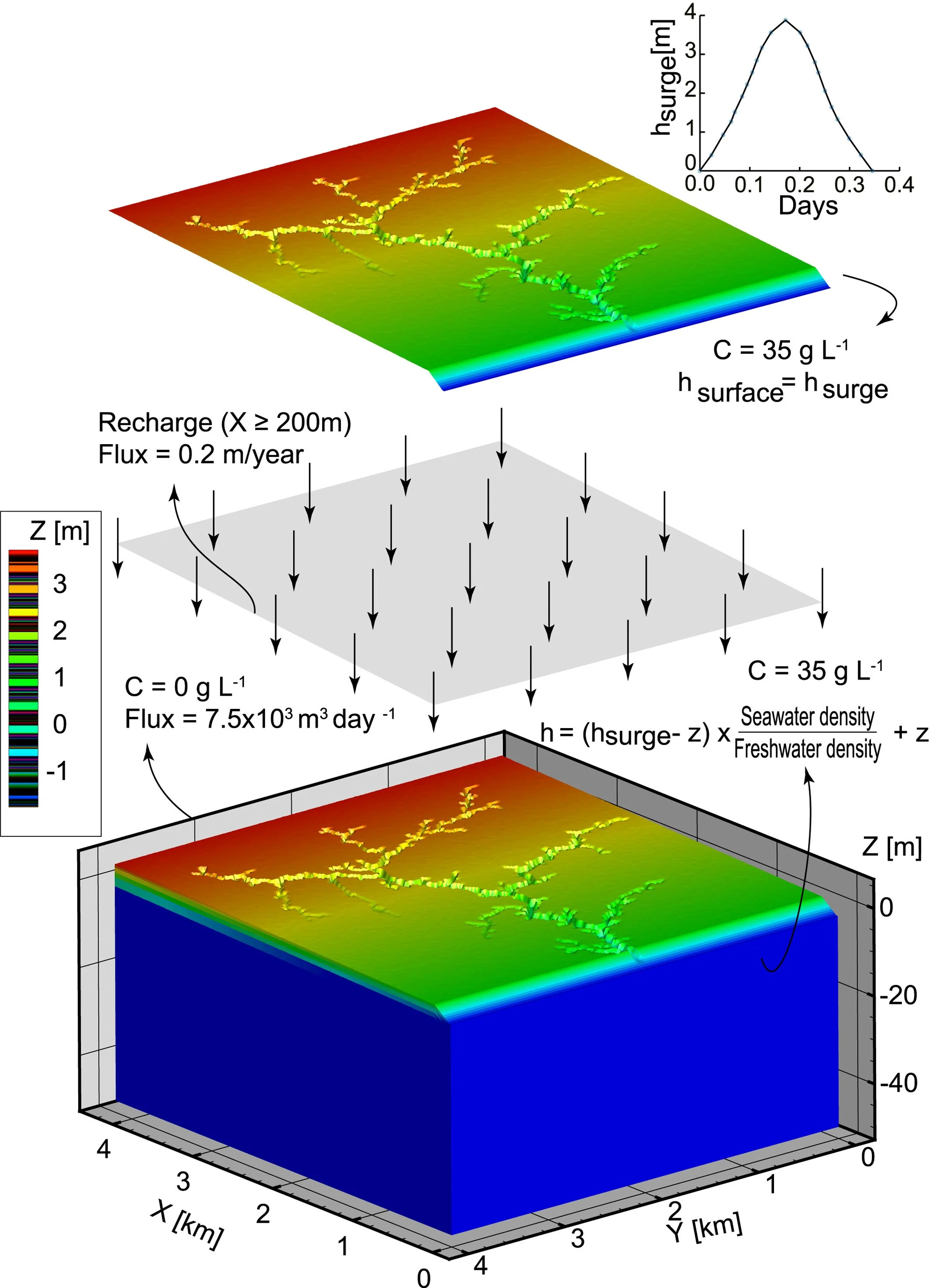
HGS RESEARCH HIGHLIGHT – Effects of Creek Topology on Salinization of Coastal Marsh Due To Storm Surges
We’re pleased to highlight this publication, co-authored by Shuangshuang Yu and colleagues, which investigates how creek network topology influences storm-surge-driven salinization in coastal marsh systems. This study leverages HydroGeoSphere (HGS) to simulate coupled surface–subsurface flow and salt transport processes under variable-density conditions, addressing long-standing challenges in understanding how geomorphology controls vertical saltwater intrusion and recovery in marsh environments.

NEW version of HGS PREMIUM July 2026 (REVISION 2992)
The HydroGeoSphere July 2026 release is now available for download.
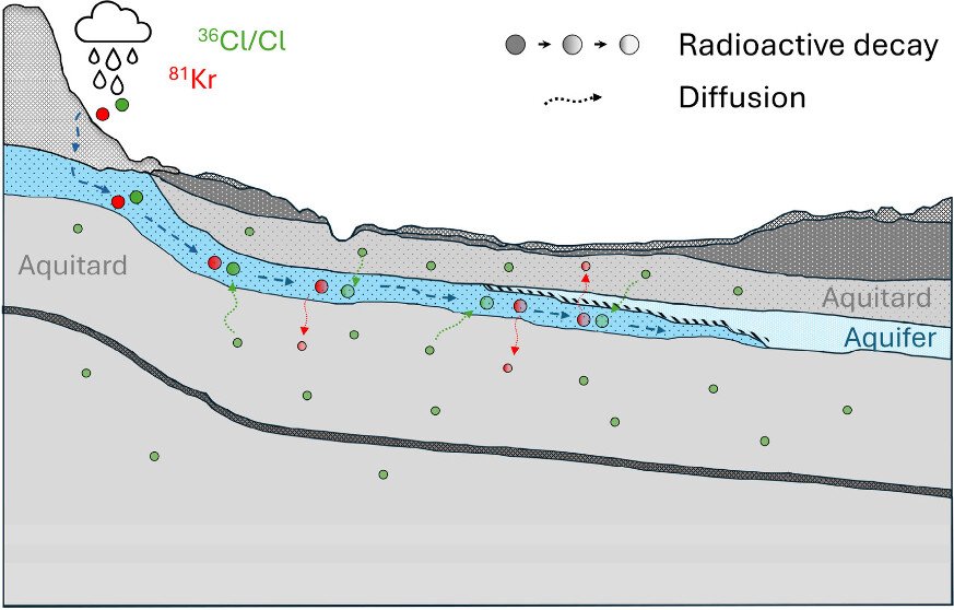
HGS RESEARCH HIGHLIGHT – Diffusion-Controlled Solute and Isotope Transport in the Milk River Aquifer System, Alberta, Canada: Implications for Dating Old Groundwater
We’re pleased to highlight this recent publication by Stephanie L. Musy and colleagues, which investigates how diffusion-controlled solute transport influences groundwater age interpretations in the Milk River Aquifer (MRA), a transboundary aquifer system spanning southern Alberta and northern Montana. The study combines multiple environmental tracers, including krypton-81 (^81Kr), chlorine-36 (^36Cl), stable chlorine isotopes (^37Cl/^35Cl), and radiocarbon (^14C), with HydroGeoSphere (HGS) simulations to better understand groundwater residence times and the processes controlling tracer distributions in old groundwater systems.

HMC Tracking with HGS: Tracking Surface Water and Groundwater Contributions to Flooding in an Alluvial Aquifer - Aquanty Webinar
We’re pleased to share the recording of our recent webinar, Tracking Surface Water and Groundwater Contributions to Flooding in an Alluvial Aquifer. This session, presented by Dr. Michael Callaghan, Senior Applications Engineer at Aquanty Inc., explores how integrated hydrologic modelling can improve understanding of groundwater flooding risks— particularly during major flood events.
Focusing on the June 2013 flooding in southern Alberta, the webinar demonstrates how groundwater flow within alluvial aquifers can contribute to infrastructure damage, even when overland flood defences are in place. Using HydroGeoSphere and its Hydraulic Mixing Cell (HMC) approach, the study tracks the dynamic contributions of surface water and groundwater throughout a flood event, offering new insight into subsurface flood mechanisms and system behaviour.
NEW version of HGS PREMIUM June 2026 (REVISION 2975)
The HydroGeoSphere June 2026 release is now available for download.
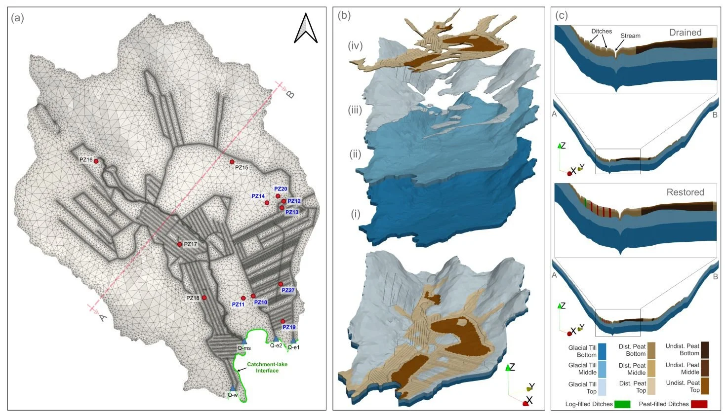
HGS RESEARCH HIGHLIGHT – How Does Rewetting Propagate Through Restored Peatlands? An Integrated Surface–subsurface Modelling Analysis of Water–table Dynamics
We’re pleased to highlight this publication, which investigates how peatland restoration alters groundwater table dynamics across drained boreal peatlands using fully integrated hydrologic modelling. This study leverages HydroGeoSphere (HGS) to simulate coupled surface–subsurface flow processes and evaluate spatial patterns of groundwater response following ditch blocking and rewetting interventions, addressing long-standing challenges in predicting restoration outcomes across heterogeneous peatland landscapes.
HGS RESEARCH HIGHLIGHT – Three‐Dimensional Geostatistical Inverse Analyses of Transient Head and Temperature Data From a Long‐Term Heat Tracer Test
We’re pleased to highlight this staff research highlighted which investigates how three-dimensional geostatistical inverse modelling can improve characterization of subsurface heterogeneity in groundwater systems. This study leverages HydroGeoSphere (HGS) to simulate fully coupled groundwater flow and transport processes within a stochastic inversion framework, addressing long-standing challenges in estimating spatially distributed hydraulic conductivity fields from limited observational data.