

Flee From Parsimony: Escaping the Boundary Condition Paradox in Groundwater Modelling - Aquanty Webinar
We’re pleased to share the recording of our recent webinar, Tracking Surface Water and Groundwater Contributions to Flooding in an Alluvial Aquifer. This session, presented by Dr. Michael Callaghan, Senior Applications Engineer at Aquanty Inc., explores how integrated hydrologic modelling can improve understanding of groundwater flooding risks— particularly during major flood events.
Focusing on the June 2013 flooding in southern Alberta, the webinar demonstrates how groundwater flow within alluvial aquifers can contribute to infrastructure damage, even when overland flood defences are in place. Using HydroGeoSphere and its Hydraulic Mixing Cell (HMC) approach, the study tracks the dynamic contributions of surface water and groundwater throughout a flood event, offering new insight into subsurface flood mechanisms and system behaviour.

HMC Tracking with HGS: Tracking Surface Water and Groundwater Contributions to Flooding in an Alluvial Aquifer - Aquanty Webinar
We’re pleased to share the recording of our recent webinar, Tracking Surface Water and Groundwater Contributions to Flooding in an Alluvial Aquifer. This session, presented by Dr. Michael Callaghan, Senior Applications Engineer at Aquanty Inc., explores how integrated hydrologic modelling can improve understanding of groundwater flooding risks— particularly during major flood events.
Focusing on the June 2013 flooding in southern Alberta, the webinar demonstrates how groundwater flow within alluvial aquifers can contribute to infrastructure damage, even when overland flood defences are in place. Using HydroGeoSphere and its Hydraulic Mixing Cell (HMC) approach, the study tracks the dynamic contributions of surface water and groundwater throughout a flood event, offering new insight into subsurface flood mechanisms and system behaviour.
Advances in HydroGeoSphere (HGS) Over The Last Decade - Aquanty Webinar
We’re pleased to share the recording of our recent webinar exploring the evolution of HydroGeoSphere (HGS) — from its origins as an ambitious integrated hydrologic modelling experiment to a widely trusted, industry-leading platform for groundwater and surface water simulation.
Presented by Dr. Hyoun-Tae Hwang, Director of HydroGeoSphere at Aquanty Inc., this session offers a comprehensive retrospective on the development of HGS since its initial launch in 2002 and its continued advancement under Aquanty since 2012. The webinar highlights key milestones, technical innovations, and the expanding capabilities that have positioned HGS at the forefront of hydrological modelling.
CWRA SK Branch Webinar: Advancing Water Intelligence: Real-Time Forecasting and Data Integration with HydroClimateSight and Canada1Water
We’re pleased to share the recording of the recent CWRA Saskatchewan Branch webinar, Advancing Water Intelligence: Real-Time Forecasting and Data Integration with HydroClimateSight and Canada1Water. Presented by Jag Phagura of Aquanty Inc., this session explores how integrated forecasting tools and national-scale datasets are helping improve modern water resource management across Canada.
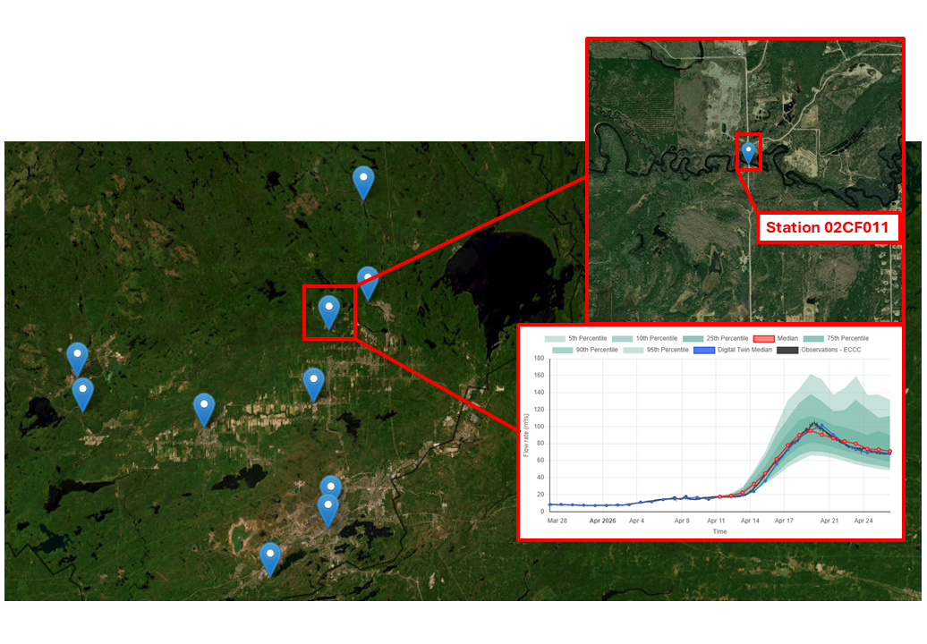
HydroSphereAI Case Study: Spring Freshet Forecasting for Hydropower Risk Awareness – Vermilion River Ontario (Station: 02CF011 - VERMILION RIVER NEAR VAL CARON) – April 2026
Between April 15 and April 22, 2026, watersheds across Greater Sudbury experienced a significant spring flood event driven by rapid snowmelt and sustained rainfall. A Flood Warning issued by Conservation Sudbury highlighted elevated inflows across the region, including the Vermilion River system near Val Caron.
While the Vermilion River is not a regulated hydropower system, Water Survey of Canada Station 02CF011 (Vermilion River near Val Caron) provides a comparable watershed area for understanding naturalized inflow dynamics relevant to hydroelectric operations across northern Ontario.
This case study demonstrates how HydroSphereAI (HSAI) captured the timing and magnitude of peak flows during a complex spring freshet event, and how similar forecasting capability can support hydropower decision-making.
HydroSphereAI Case Study: Nanaimo River Near Cassidy – January 2026 High-Flow Event
On January 12, 2026, the Nanaimo River near Cassidy (Water Survey of Canada Station 08HB034) experienced a significant high-flow event, cresting at the 2-year flood mark. Winter storm systems sweeping across Vancouver Island brought prolonged precipitation to the watershed, driving river discharge well above average levels for the season. This case study highlights how an early release version of HydroSphereAI (HSAI) tracked the event and how this information could be used by stakeholders and water managers.
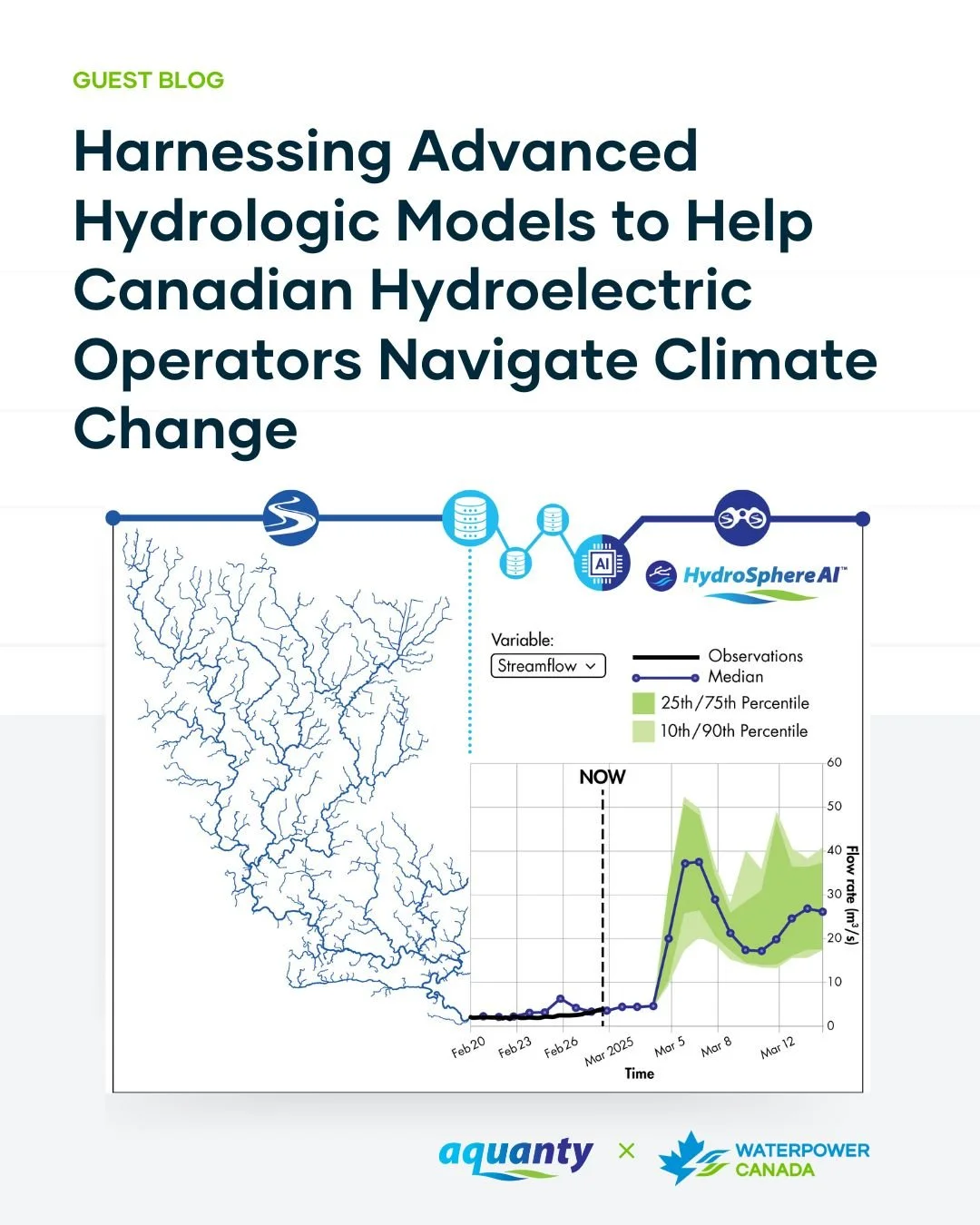
Aquanty Featured in WaterPower Canada Guest Blog: Navigating Climate Change in Hydropower
We’re pleased to share that Aquanty recently contributed a guest blog post to WaterPower Canada, authored by Dr. Andre Erler, Senior Climate Scientist at Aquanty. The article “Harnessing Advanced Hydrologic Models to Help Canadian Hydroelectric Operators Navigate Climate Change” explores how advanced hydrologic modelling and forecasting tools can help Canadian hydroelectric operators navigate increasing uncertainty driven by climate change.
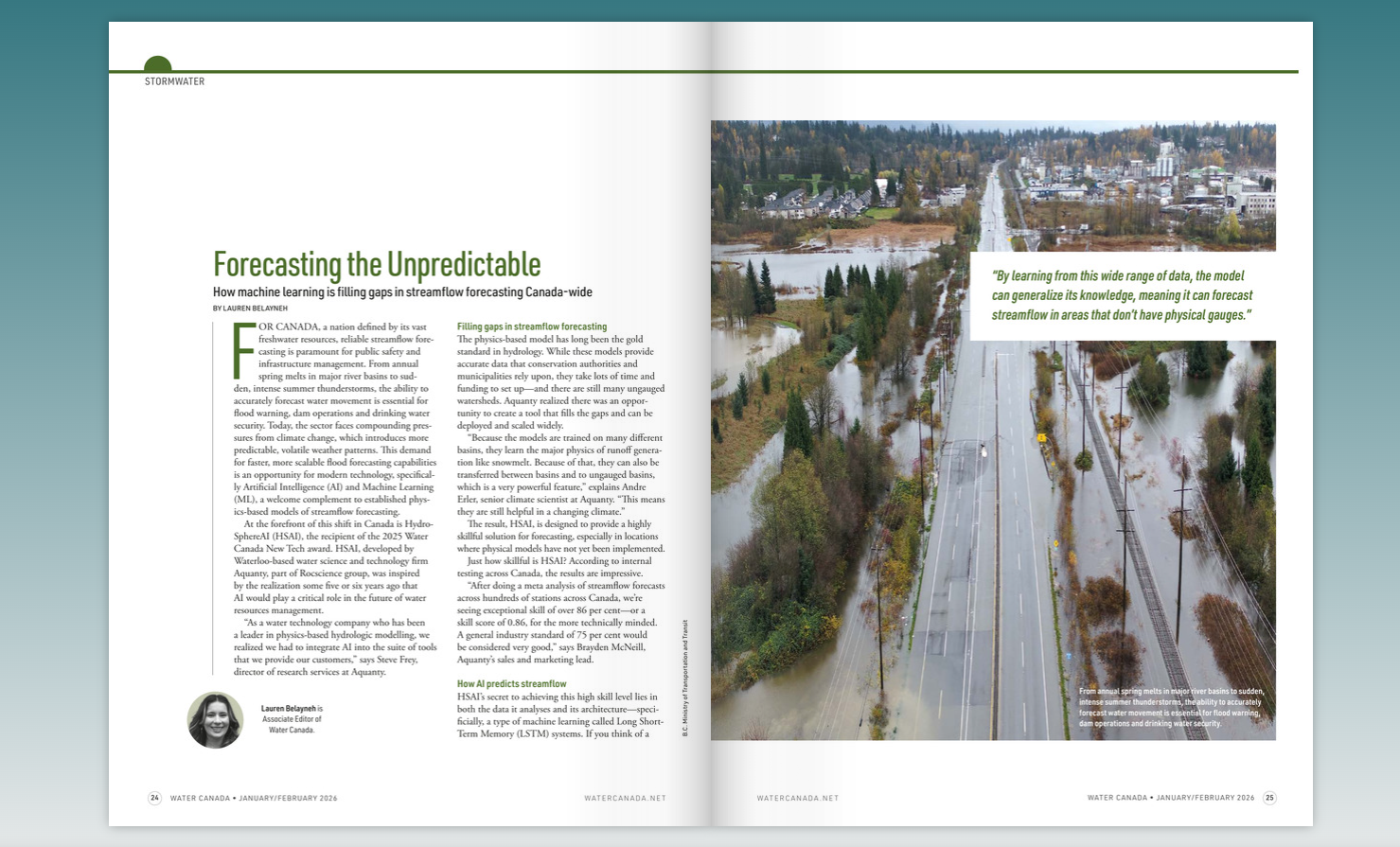
HydroSphereAI Featured in Water Canada’s January/February 2026 Magazine
We’re excited to share that HydroSphereAI (HSAI) is featured in the January/February 2026 issue of Water Canada, highlighting how machine learning is helping close critical gaps in streamflow forecasting across Canada.
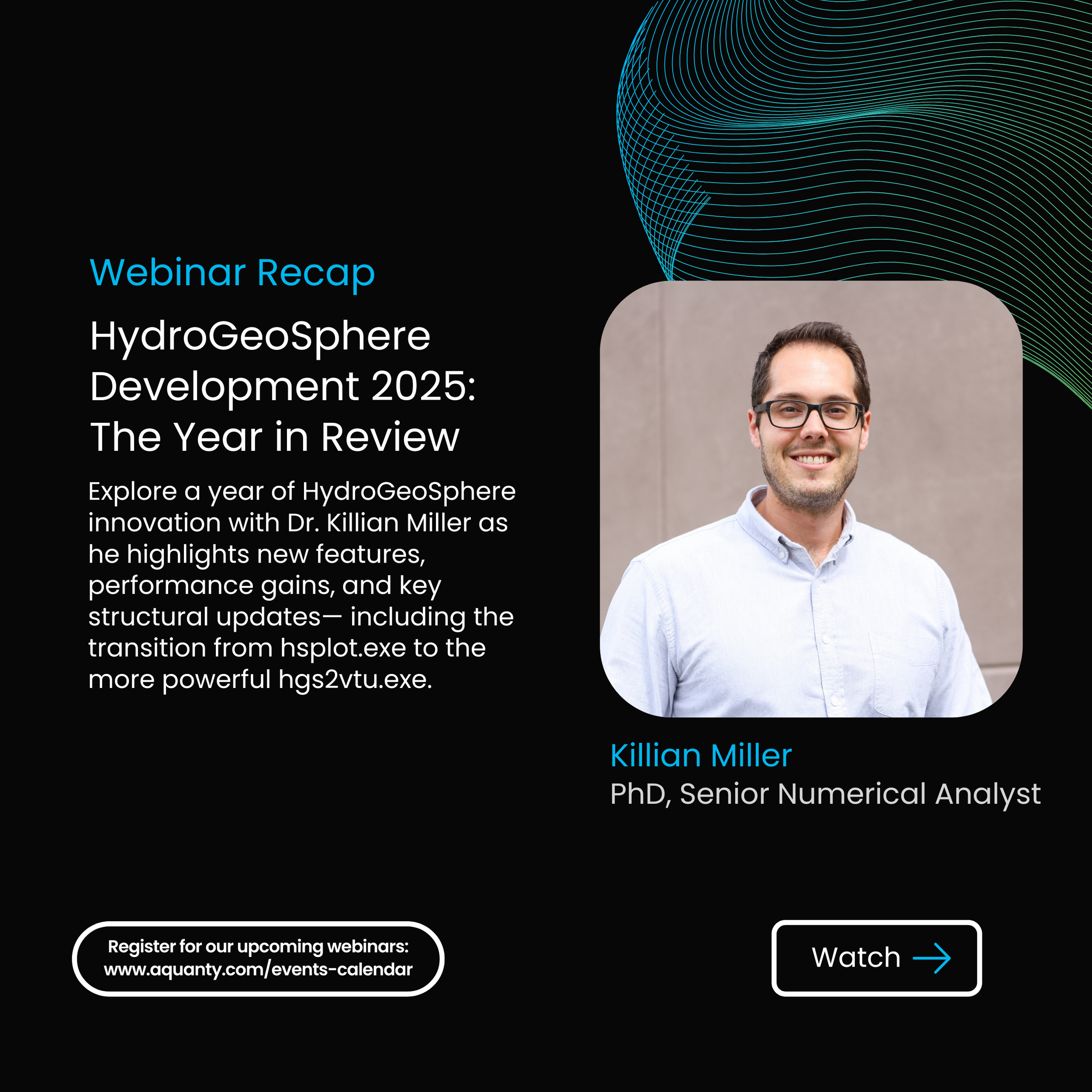
HydroGeoSphere Development 2025: The Year in Review - Aquanty Webinar
We’re pleased to share the recording of our webinar ‘HydroGeoSphere Development 2025: The Year in Review’. This session, presented by Dr. Killian Miller, Numerical Analysis Specialist at Aquanty, looks back at a year of major advancements to the HydroGeoSphere platform— highlighting new features, performance improvements, and key structural updates across the HGS ecosystem.
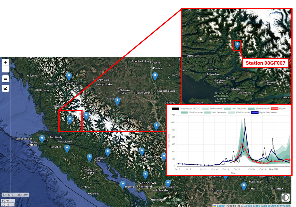
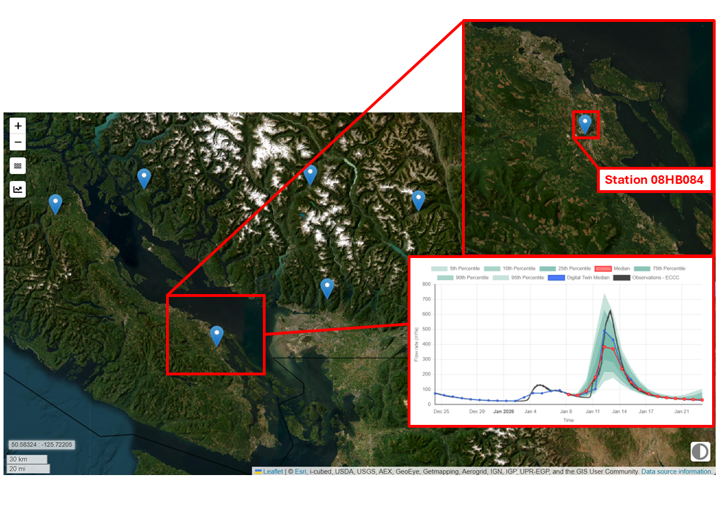
HydroSphereAI Case Study: Wakeman River
During October and November 2025, a series of back-to-back Pacific storm systems brought steady rainfall across the central coast of British Columbia. Such events are a common occurrence in the Pacific Northwest and are intensifying in a warmer climate.