
HGS RESEARCH HIGHLIGHT – Towards a climate-driven simulation of coupled surface-subsurface hydrology at the continental scale: a Canadian example

Chen, J., Sudicky, E. A., Davison, J. H., Frey, S. K., Park, Y.-J., Hwang, H.-T., Erler, A. R., Berg, S. J., Callaghan, M. V., Miller, K., Ross, M., & Peltier, W. R. (2019). Towards a climate-driven simulation of coupled surface-subsurface hydrology at the continental scale: a Canadian example. In Canadian Water Resources Journal / Revue canadienne des ressources hydriques (Vol. 45, Issue 1, pp. 11–27). Informa UK Limited. https://doi.org/10.1080/07011784.2019.1671235
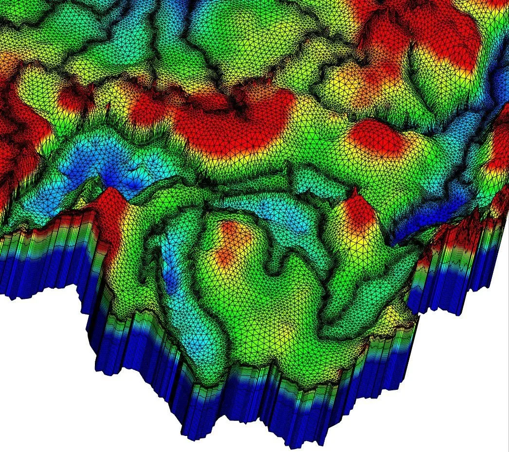
Figure 3. A close-up look at the 3D triangular prism grid along the Great Lakes region. Hot colours represent high elevations and cold colours show the low elevation. The irregular mesh resolution is refined at the lake shore and along major rivers. Source: Authors.
This paper from 2019, co-authored by Aquanty staff, researchers at the University of Waterloo and the Catholic University of America, provides a framework for continental scale integrated hydrologic modelling and is a precursor to Aquanty’s flagship Canada1Water project.
The HydroGeoSphere simulation platform was used to model the integrated surface/subsurface hydrologic system, with the model being dubbed the Canadian Continental Basin Model (CCBM). As a fully physics-based simulation platform (with a de-emphasis on empirical relationships), HydroGeoSphere is a uniquely powerful tool for modelling the behaviour of hydrologic systems under unknown (i.e. climate change) conditions. Furthermore, since HGS models 3-dimensional unsaturated zone flow, it’s one of the only commercially available modelling platforms that can provide insights into all three types of flood risk (pluvial, fluvial, groundwater) and the ultimate source of stream channel flow (i.e. overland runoff vs groundwater exfiltration).
In the case of the CCBM, the conceptual model spanned 10.5 million sq-km and was informed with data from geology maps and past climate knowledge. The model mesh was adapted to resolve important hydrologic features including lakes, rivers and streams, with topography defined at a 1 sq-km resolution from the HYDRO1K digital elevation model, with lake bathymetry obtained from ETOPO5 burned into the overall model topography. Special emphasis was placed on the Laurentian Great Lakes to ensure that the model would accurately reproduce the water cycle in the Great Lakes Basin. The subsurface domain was discretized into seven layers that represent spatially distributed soil, and surficial and bedrock hydrostratigraphy.
The historic CCBM simulations were forced with climatology from observation-based gridded climate data obtained from the Canadian Forest Service. Annually average precipitation and potential evapotranspiration were the primary boundary conditions for the 1981-2010 simulations that were conducted. The impacts of permafrost hydrology were also important to consider as they have a significant influence on the water cycle in Canada’s cold regions. This study “uniquely include[d] both permafrost and discontinuous permafrost zones, which considerably decrease the conductivity of near-surface soils, producing greater overland flow, while reducing infiltration and altering groundwater recharge.”
The results of the CCBM showed that despite the large-scale finite elements in the 3D mesh, an integrated hydrologic modelling approach allowed for accurate evaluation of hydrology at the continental scale. As global freshwater resources are at risk due to climate change, population growth and agriculture intensification, these modelling tools are going to be more in demand and will help with making decisions that are often affected by a lack of information. Another area of focus of this study was cold regions, as they are impacted more on account of permafrost and glacial ice cover loss. Additionally, permafrost and the active layer have different varying hydraulic properties which must also be accounted for in cold region hydrologic analysis.
Numerical modelling techniques are being relied on more heavily as computational resources become more readily available, and the integrated modelling approach is becoming more feasible at larger scale. HydroGeoSphere has been used to model various large-scale basins previously and has delivered accurate results. However, this study represents the largest scale fully integrated model simulation as of 2019.
This study showed that the Canadian Continental Basin Model is another important step in modelling integrated hydrology at the continental scale and provides knowledge and insights to support decisions for climate change adaptation and mitigation measures to secure water resources into the future.
Does this interest you? Check out the Canada1Water Project and learn about how the next generation of continental scale modelling is being implemented today!
“Unlike traditional hydrologic models, there are no internal sinks or sources that connect the surface and subsurface flow regimes. Fundamentally, the primary forcing of the HGS model is precipitation and potential evapotranspiration”
CLICK HERE TO READ THE ARTICLE.
Abstract:
The development of new, large-scale tools to evaluate water resources is critical to understanding the long-term sustainability of this resource under future land use, climate change, and population growth. In cold and humid regions it is imperative that such tools consider the hydrologic complexities associated with permafrost and groundwater-surface water (GW-SW) interactions, as these factors are recognized to have significant influence on the global water cycle. In this work we present a physics-based, three-dimensional, fully-integrated GW-SW model for Continental Canada constructed with the HydroGeoSphere simulation platform. The Canadian Continental Basin Model (CCBM) domain, which covers approximately 10.5 million km2, is discretized using an unstructured control-volume finite element mesh that conforms to key river basin boundaries, lakes, and river networks. In order to construct the model, surficial geology maps were assembled, which were combined with near-surface information and bedrock geology into a seven-layer subsurface domain. For the large-scale demonstration, the model was used to simulate historic groundwater levels, surface water flow rates (R2=0.85), and lake levels (R2=0.99) across the domain, with results showing that these targets are well reproduced. To demonstrate the regional-scale utility, simulation results were used to perform a regional groundwater flow analysis for western Canada and a water balance analysis for the Laurentian Great Lakes (Superior, Michigan, Huron, Erie and Ontario). The outcome of this work demonstrates that large-scale fully-integrated hydrologic modeling is possible and can be employed to quantify components of a large-scale water balance that are otherwise difficult or impossible to obtain.