

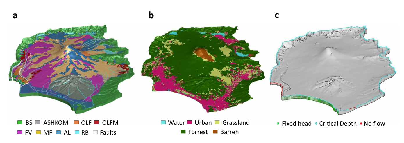
HGS RESEARCH HIGHLIGHT – Modeling a geologically complex volcanic watershed for integrated water resources management in Mt. Fuji, Japan
This publication presents a three-dimensional geological and integrated hydrological modelling dataset developed for the Mt. Fuji volcanic watershed in Japan. This study leverages HydroGeoSphere (HGS) to simulate coupled surface–subsurface flow and transport processes in a geologically complex volcanic catchment, addressing long-standing challenges in representing groundwater flow pathways and hydrologic interactions in structurally heterogeneous mountain environments. The resulting dataset provides a physically consistent modelling framework to support interdisciplinary water resources research and scenario-based hydrologic simulations.
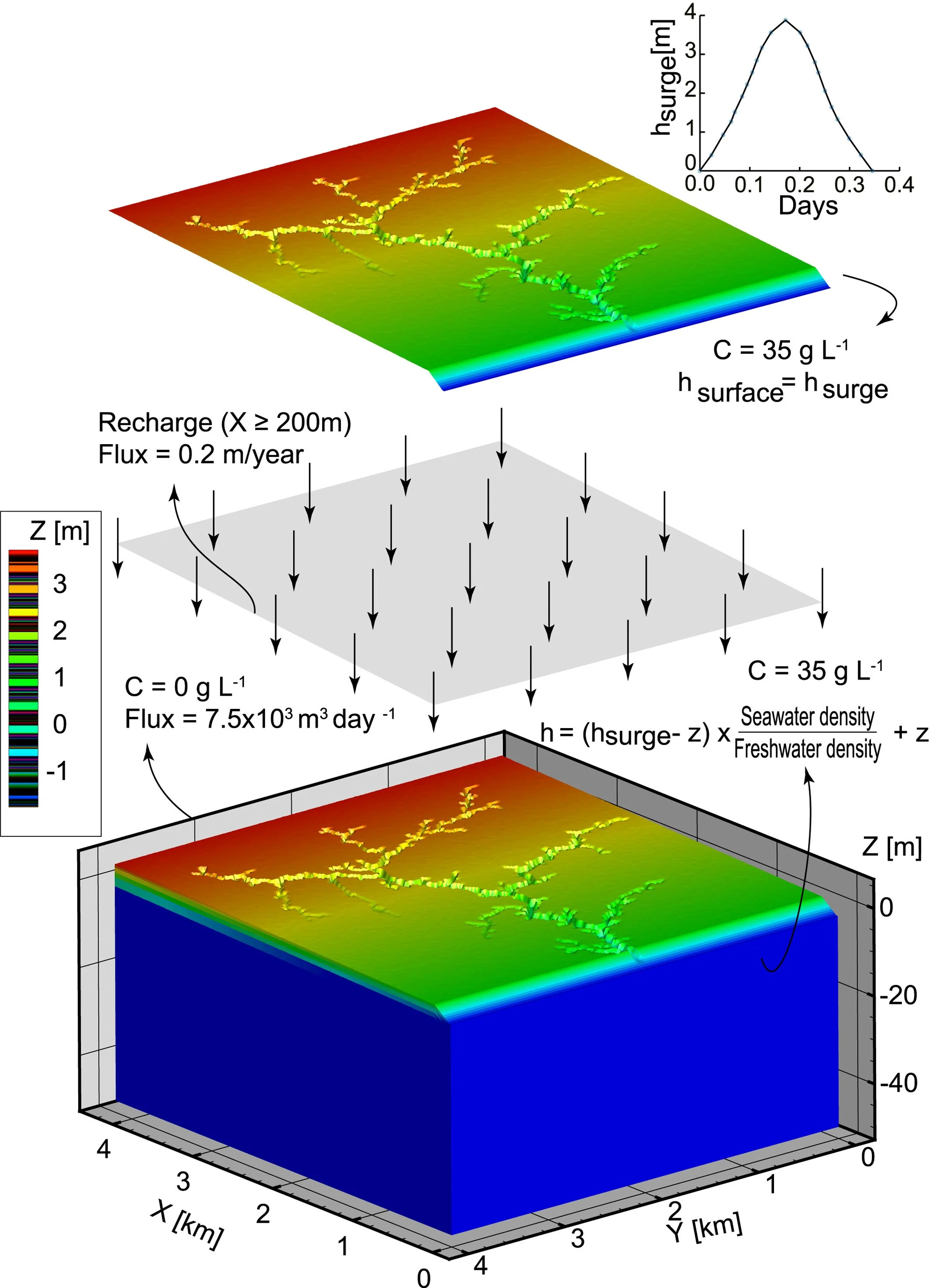
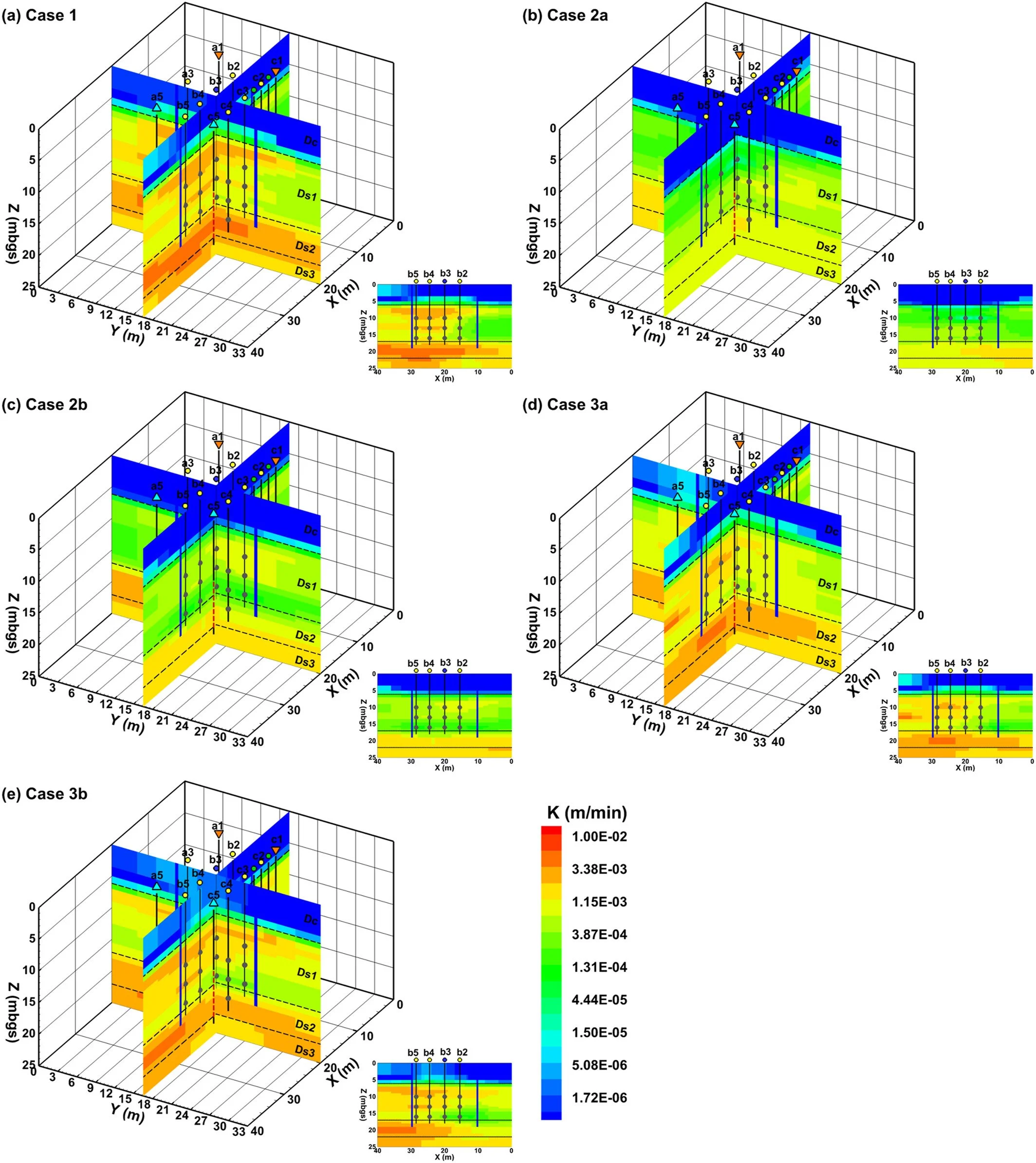
HGS RESEARCH HIGHLIGHT – Effects of Creek Topology on Salinization of Coastal Marsh Due To Storm Surges
We’re pleased to highlight this publication, co-authored by Shuangshuang Yu and colleagues, which investigates how creek network topology influences storm-surge-driven salinization in coastal marsh systems. This study leverages HydroGeoSphere (HGS) to simulate coupled surface–subsurface flow and salt transport processes under variable-density conditions, addressing long-standing challenges in understanding how geomorphology controls vertical saltwater intrusion and recovery in marsh environments.
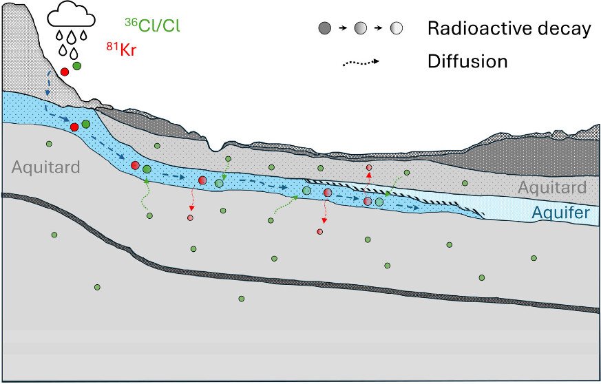
HGS RESEARCH HIGHLIGHT – Diffusion-Controlled Solute and Isotope Transport in the Milk River Aquifer System, Alberta, Canada: Implications for Dating Old Groundwater
We’re pleased to highlight this recent publication by Stephanie L. Musy and colleagues, which investigates how diffusion-controlled solute transport influences groundwater age interpretations in the Milk River Aquifer (MRA), a transboundary aquifer system spanning southern Alberta and northern Montana. The study combines multiple environmental tracers, including krypton-81 (^81Kr), chlorine-36 (^36Cl), stable chlorine isotopes (^37Cl/^35Cl), and radiocarbon (^14C), with HydroGeoSphere (HGS) simulations to better understand groundwater residence times and the processes controlling tracer distributions in old groundwater systems.
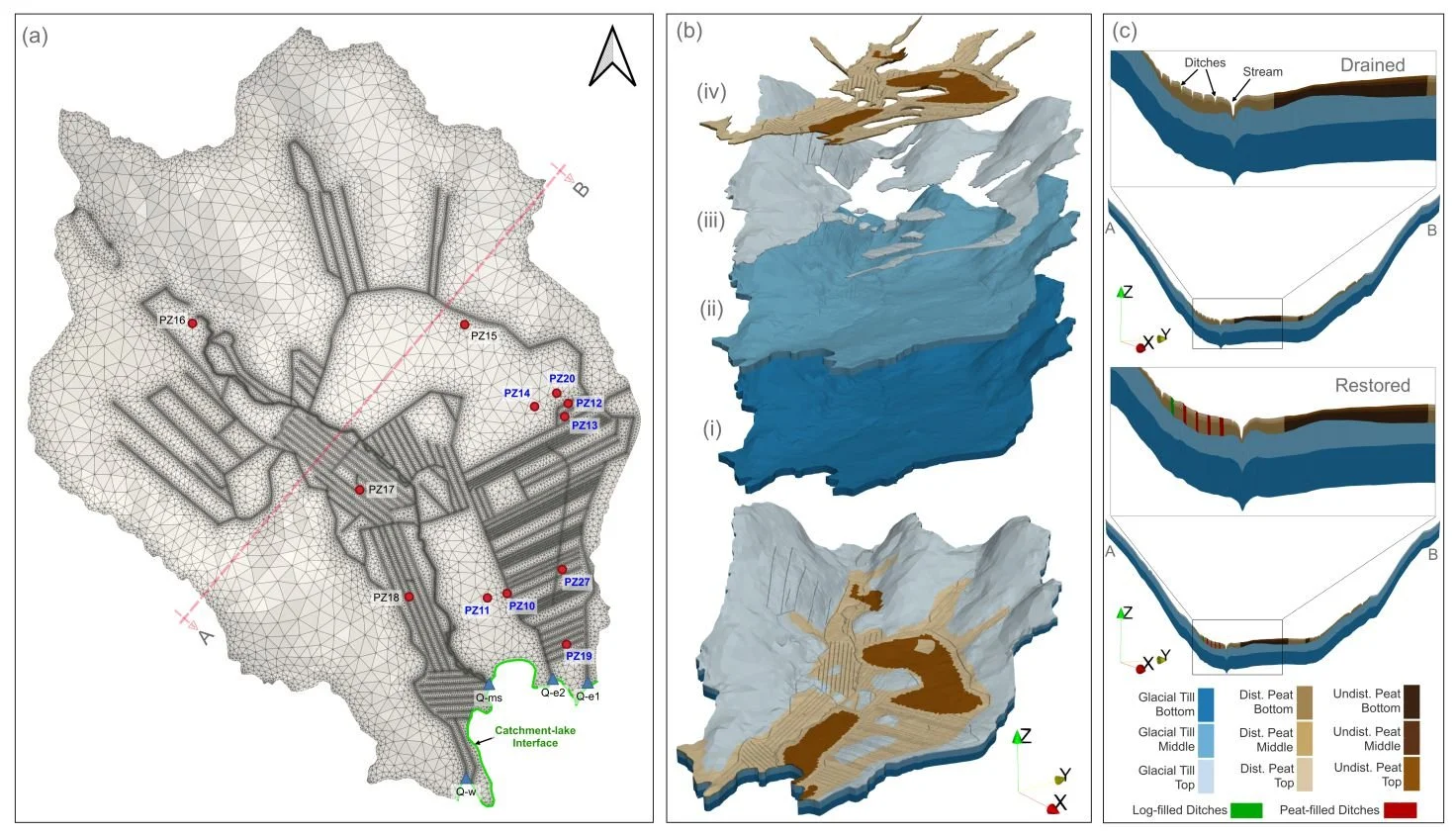
HGS RESEARCH HIGHLIGHT – How Does Rewetting Propagate Through Restored Peatlands? An Integrated Surface–subsurface Modelling Analysis of Water–table Dynamics
We’re pleased to highlight this publication, which investigates how peatland restoration alters groundwater table dynamics across drained boreal peatlands using fully integrated hydrologic modelling. This study leverages HydroGeoSphere (HGS) to simulate coupled surface–subsurface flow processes and evaluate spatial patterns of groundwater response following ditch blocking and rewetting interventions, addressing long-standing challenges in predicting restoration outcomes across heterogeneous peatland landscapes.
HGS RESEARCH HIGHLIGHT – Three‐Dimensional Geostatistical Inverse Analyses of Transient Head and Temperature Data From a Long‐Term Heat Tracer Test
We’re pleased to highlight this staff research highlighted which investigates how three-dimensional geostatistical inverse modelling can improve characterization of subsurface heterogeneity in groundwater systems. This study leverages HydroGeoSphere (HGS) to simulate fully coupled groundwater flow and transport processes within a stochastic inversion framework, addressing long-standing challenges in estimating spatially distributed hydraulic conductivity fields from limited observational data.
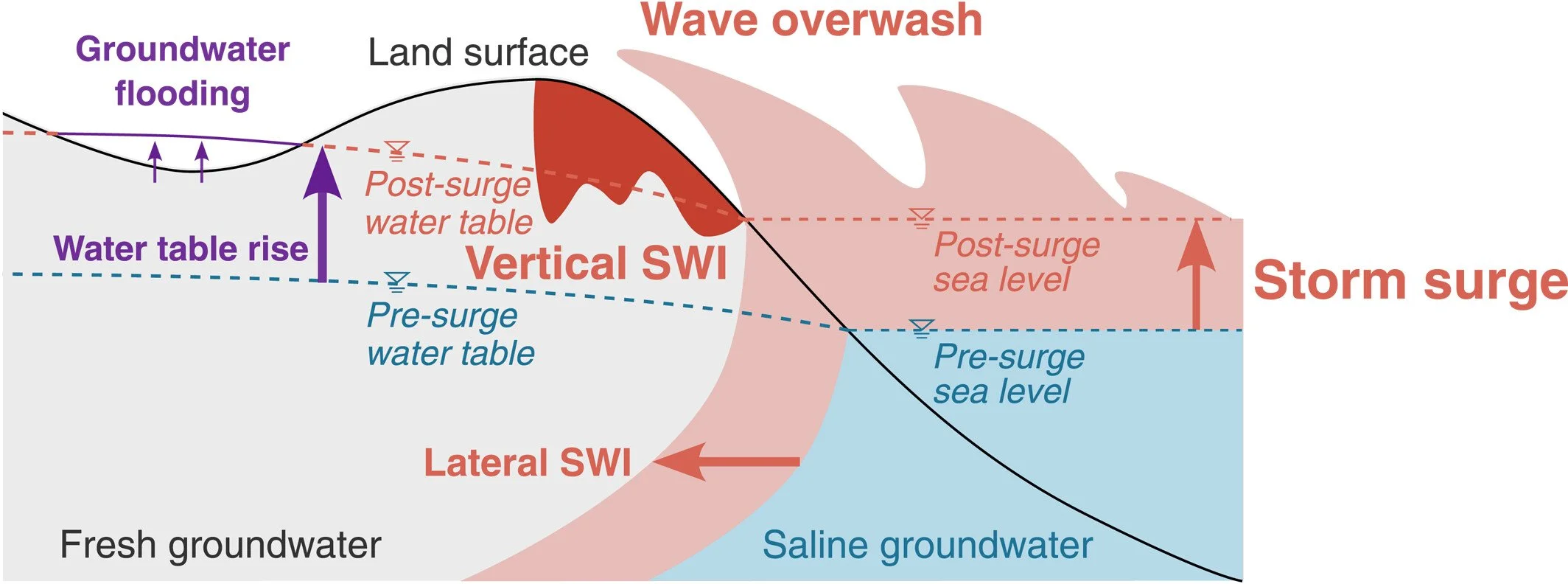
HGS RESEARCH HIGHLIGHT – Climate Change Alters Post-Surge Recovery of Coastal Aquifers
This publication co-authored by Satoshi Tajima, René Therrien and Philip Brunner investigates how climate change influences the recovery of coastal aquifers following storm surge events. This study leverages HydroGeoSphere (HGS) to simulate coupled groundwater flow and variable-density salt transport, addressing long-standing challenges in understanding how coastal aquifers respond to storm-driven seawater intrusion and how recovery dynamics may change under future climatic conditions.
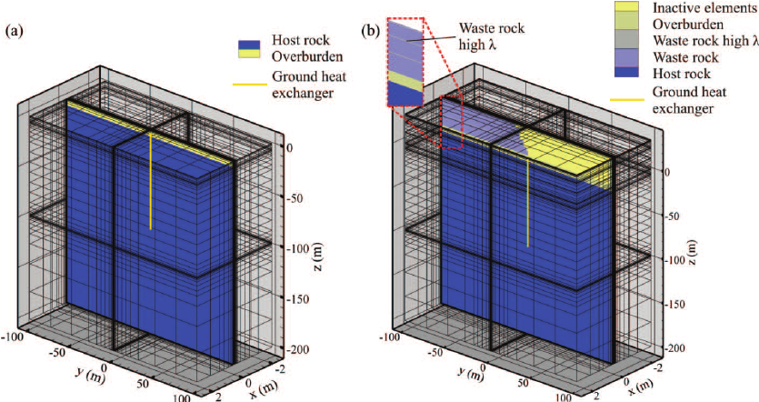
HGS RESEARCH HIGHLIGHT – Numerical simulation of geothermal energy transfer beneath exothermic waste rock piles
This publication, co-authored by Jasmin Raymond, René Therrien, Louis Gosselin, and René Lefebvre, which investigates how geothermal energy can be harnessed beneath exothermic waste rock piles to improve the performance of ground-coupled heat pump systems. This study leverages HydroGeoSphere (HGS) to simulate coupled subsurface fluid flow and heat transfer, addressing long-standing challenges in quantifying how enhanced subsurface temperatures generated by sulfide mineral oxidation can reduce the required length and number of ground heat exchangers.
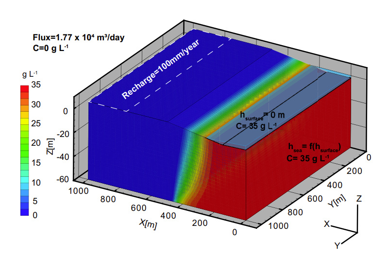
HGS RESEARCH HIGHLIGHT – Saltwater Circulation Driven by Shoreline Curvature in Coastal Aquifers
This publication co-authored by Xuan Yu, Lanxuan He, Rongjiang Yao, Zexuan Xu, George Kourakos, Jie Yang, and Franklin W. Schwartz, which investigates how shoreline curvature influences saltwater circulation, freshwater–saltwater mixing, and submarine groundwater discharge (SGD) in coastal aquifers. This study leverages HydroGeoSphere (HGS) to perform fully three-dimensional, variable-density groundwater flow and salt transport simulations, addressing long-standing limitations of two-dimensional coastal aquifer models that neglect along-shore and lateral flow processes.
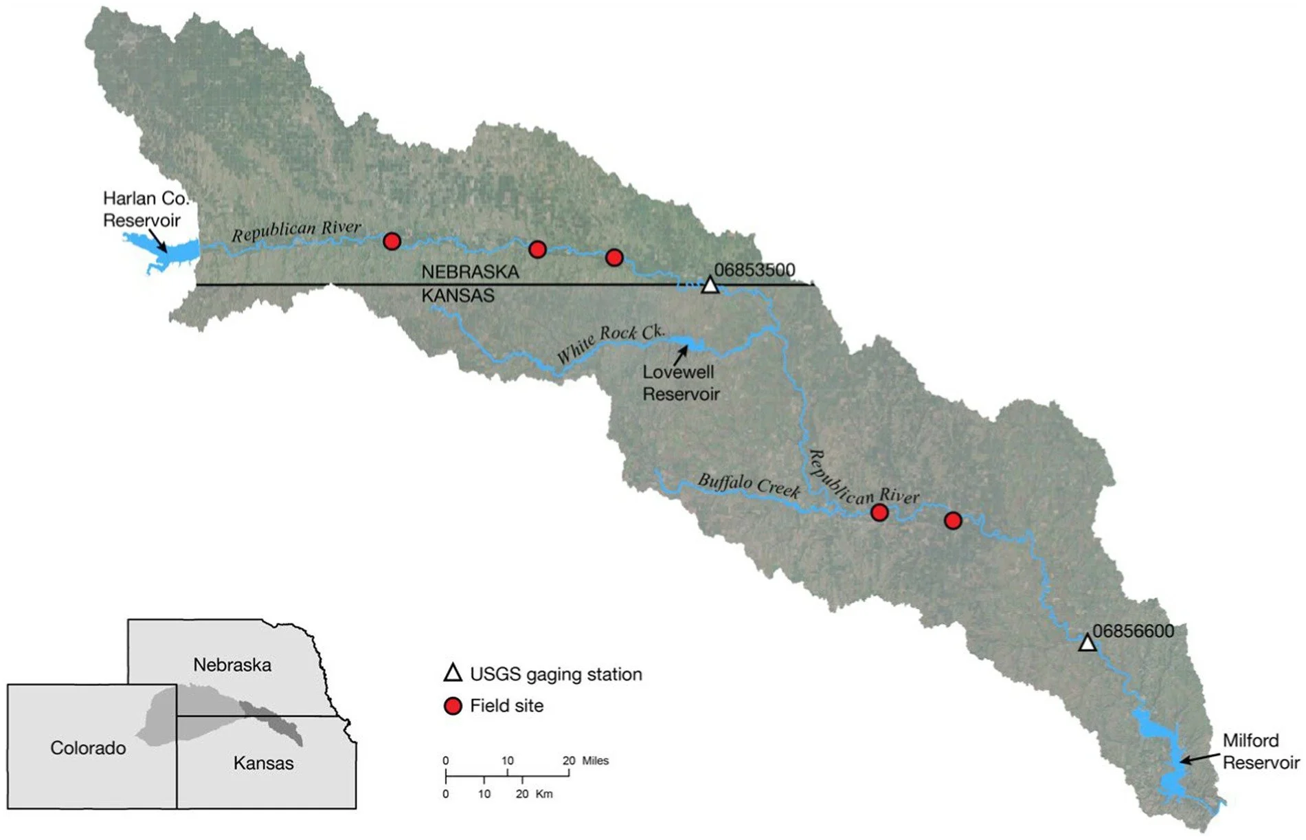
HGS RESEARCH HIGHLIGHT – Quantifying the effects of water management decisions on streambank stability
This publication co-authored by Q. Wei, A. Brookfield, and A. Layzell, investigates how water management decisions influence streambank stability by altering subsurface hydrologic conditions. This study leverages HydroGeoSphere (HGS), coupled with the surface water operations model OASIS, to address long-standing challenges in linking reservoir operations, groundwater pumping, and hydrologic dynamics to the physical mechanisms driving streambank failure.
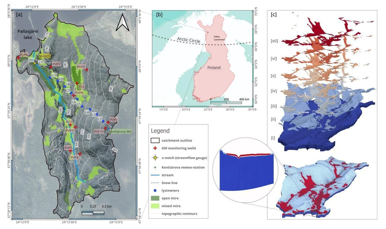
HGS RESEARCH HIGHLIGHT – Stable Water Isotopes Improve Calibration and Flow path Identification in Integrated Hydrological Model
This publication co-authored by Omar Ashraf Nimr, Hannu Marttila, Anna Autio, and Pertti Ala-Aho, investigates how stable water isotopes can improve calibration, uncertainty reduction, and flow path identification in fully integrated surface–subsurface hydrological models. This study leverages HydroGeoSphere (HGS) to explicitly simulate both hydrologic processes and isotope transport, addressing long-standing challenges related to equifinality and internal process realism in groundwater–surface water modelling.