
HGS RESEARCH HIGHLIGHT – Evaluating Climate Change Impacts on Soil Moisture and Groundwater Resources Within a Lake-Affected Region

Erler, A. R., Frey, S. K., Khader, O., d’Orgeville, M., Park, Y., Hwang, H., Lapen, D. R., Peltier, W. R., & Sudicky, E. A. (2019). Evaluating Climate Change Impacts on Soil Moisture and Groundwater Resources Within a Lake‐Affected Region. In Water Resources Research (Vol. 55, Issue 10, pp. 8142–8163). American Geophysical Union (AGU). https://doi.org/10.1029/2018wr023822
“This study is the first of its kind to couple dynamically downscaled climate projections with a fully integrated hydrologic model in order to assess climate change impacts on groundwater and soil moisture in a region where the local climate is heavily affected by major surface water bodies.”
CLICK HERE TO READ THE ARTICLE.
This study by researchers at Aquanty, the University of Waterloo, the University of Toronto, and Agri-Food Canada investigates how climate change could impact groundwater and soil moisture in watershed within the Great Lakes Basin (GLB). Groundwater is a resource that is relied on for agriculture, industry, municipalities, and drinking water. Approximately one quarter of the 33 million inhabitants of the GLB depend on groundwater as their primary freshwater source. Given its high value as a natural resource, the impacts of climate change on groundwater need to be well understood, but fully-integrated models are still rarely being used for climate change impact analysis.
Interested in learning more about Aquanty’s research on economic valuation of ecosystem services? Watch our 2022 webinar “Rising importance of economic valuation of ecosystem services in protecting Canada's vital resources”
The hydrology of the 6,800 sq-km Grand River Watershed (GRW) is modelled here using a physics-based approach, powered by HydroGeoSphere. HGS was used for this study because it is an efficient simulation platform at all scales (sub-kilometre in this study) and incorporates all hydrologic processes in the terrestrial hydrosphere allowing for full integration of groundwater, surface water and climate scenarios. The model was built with 21 vertical layers and a variable-resolution mesh with a minimum spacing of 500 m.
Many processes impacting regional hydrology need to be included as they could potentially impact the long-term sustainability and status of the region’s groundwater resources. Groundwater levels, recharge/infiltration and surficial soil moisture trends are all interdependent, and the various impacts of climate change on these hydrologic criteria may be compounded and aggravate the overall impact on regional water resources. Additionally, the hydrologic behavior is highly seasonal, so isolating the specific climate change impacts at different times can be difficult.
To accurately simulate the hydrology of the GRW, the HGS model was initially calibrated using a 30-year dataset of gridded observational forcing data using monthly normals (precipitation, potential evapotranspiration and temperature). Future climatological forcing data was based on a global climate model (the Community Earth System Model version 1.2) that was dynamically downscaled to account for the significant impacts that the Great Lakes have on the regional climate. The high-resolution/regionally downscaled climate projections were created using the Weather Research and Forecasting Model (WRF) augmented by the so-called Freshwater Lake model (FLake) to represent the seasonal cycle of the Great Lakes. While the global climate models were downscaled to a variety of scales, the study here focuses on the 10-km resolution downscaling product. Finally, the HGS model of the GRW was forced under two climate scenarios spanning the range of plausible climate projections: WRF T (representing a drier overall future climate) and WRF G (representing a wetter overall future climate).
This study concluded that the groundwater levels will change in the coming years, although the overall hydrologic response varied under the WRF T and WRF G scenarios. Under both scenarios an increase in precipitation is expected in the winter, but a decrease in total snow. However, the two scenarios do present divergent overall impacts on terrestrial hydrology, attributed partly to differences in summer precipitation patterns (higher summer precip. in the WRF G scenario, lower summer precip. in the WRF T scenario). The drier WRF T scenario results in lower streamflows in all seasons, whereas the wetter WRF G scenario results in higher streamflow in all seasons except spring. Regional trends in groundwater level follow the general trend direction of surface water but are strongly modulated by local topography and physiography: groundwater table changes seem to be most prevalent in areas where the water table is >20m below surface, while areas with shallow groundwater are less affected. Surficial soil moisture is impacted more directly by variations in climatology, with increases in precipitation (i.e. the wetter WRF G scenario) resulting in more homogenous increases in soil moisture across the region, while decreases in precipitation (i.e. the drier WRF T scenario) have the opposite effect.
Overall, this study provides an insightful initial attempt at simulating the impact of climate change on groundwater resources under a range of climate scenarios and provides a blueprint for future studies. The framework of this study can be translated to other watersheds with similar characteristics to evaluate the impacts of climate change on groundwater and soil moisture. However, the approach here (seasonally averaged climatological cycles) may not be suitable for all conditions such as extreme flood/drought events, and future work will focus on applying fully transient conditions to the simulation framework.
CLICK HERE TO READ THE ARTICLE.
Abstract:
The impact of climate change on surface water resources is reasonably well studied. However, the impact on groundwater resources has only been considered by a few studies worldwide. Here we present an analysis of climate change impacts on groundwater resources in a well-instrumented 6,800-km2 watershed in the Laurentian Great Lakes Basin. We employ a physics-based modeling pipeline consisting of an ensemble of high-resolution regional climate model projections based on the Weather Research and Forecasting model and the fully integrated three-dimensional hydrologic model HydroGeoSphere. The Weather Research and Forecasting model is run at a resolution as fine as 10 km using two different physics configurations, while HydroGeoSphere simulates the terrestrial hydrosphere at subkilometer scale, from deep groundwater to surface water, including surface water-groundwater interactions. The two Weather Research and Forecasting model physics configurations exhibit opposite climate change responses in summer precipitation. The hydrologic simulations follow the climate forcing, but due to the memory of the subsurface, differences in summer affect the entire seasonal cycle. In the drier climate scenario groundwater levels and recharge decline, while in the wetter scenario groundwater levels rise (recharge remains unchanged). Soil moisture changes accordingly, but primarily in late summer. It is also shown that the magnitude of climate change impacts on groundwater is strongly modulated by local physiographic features. In particular, regions where the groundwater table is deep (below 2 m; 15% of the area) show a high sensitivity to changes in climate forcing. Furthermore, changes in groundwater levels, recharge, and soil moisture typically occur in the same regions, suggesting potentially compounding impacts.
Key Points:
Climate change impact modeling using a regional climate model and a fully integrated surface water-groundwater model
Primary uncertainty in summer precipitation controls soil moisture and has delayed influence over seasonal groundwater fluctuations
Magnitude of climate change impacts on soil moisture and groundwater are strongly modulated by local physiography
Plain Language Summary:
In many watersheds groundwater maintains minimum flows and soil moisture during dry periods. In this study we investigate the possible impacts of different climate change scenarios on groundwater and soil moisture in a major watershed in southern Ontario, Canada. We use a state‐of‐the‐art hydrologic model that simulates groundwater and surface water, together with climate scenarios that are derived from an ensemble of high‐resolution regional climate projections. The main result is that changes in groundwater and soil moisture generally follow the direction of changes seen in net precipitation from the climate models, but the spatial pattern and magnitude of changes are strongly modulated by local topography and geology. In general, regions that have a deeper groundwater table today are more sensitive and may experience larger changes in the future. As expected, our simulations do not match observations perfectly, but we believe that we are able to identify uncertainties that are likely to affect the conclusions. The primary uncertainty here lies in the change in summer precipitation, which dominates the climate change response: it is large enough to either cause a drier or a wetter future, and the interaction between surface water and groundwater appears to spread changes in summer across the entire year.

Figure 1. (a) The general location of the Grand River Watershed within the Great Lakes Basin. (b) Topography, stream network, and groundwater observation wells. (c) Stratigraphic layers of the GRW model.

Figure 5. (top) Annual average depth to the groundwater table and (bottom) changes in the depth to the groundwater table.

Figure 7. The average seasonal cycle of watershed-averaged depth to the groundwater table and relative soil saturation for the (left) WRF G ensemble and the (right) WRF T ensemble, (top) without and (bottom) with bias correction for the historical, midcentury, and end-century periods.

Figure 8. (top) Relative soil saturation at 0.75-m depth and (bottom) changes in relative soil saturation. Values have been averaged over July, August, and September (JAS).
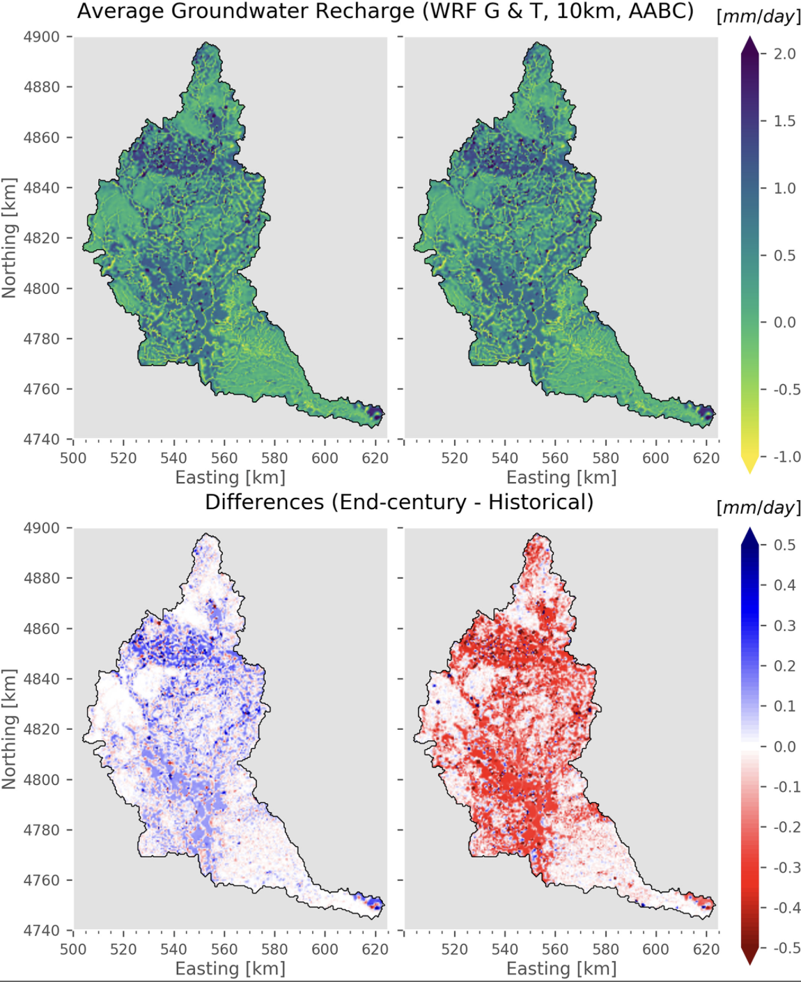
Figure 10. (top) Annual average groundwater recharge (defined as infiltration minus evapotranspiration from porous media) and (bottom) changes therein at the end of the twenty-first century.