

Coastal Hydrology, Thermal Energy and Density-Driven Flow Applications
The effects of temperature and salinity on fluid density can be critical to accurately simulate groundwater movement and to sustainably manage groundwater resources in coastal regions. Density-dependent flow modelling incorporates these effects into hydrogeological analyses and decision-making processes.
HydroGeoSphere is an industry leading solution for accurately simulating density driven flow systems, with full support for density effects in all available model domains including surface and groundwater flow, fracture flow, and more.
Benefits
Model climate change impacts to support adaptation plans
Improve resilience to extreme weather
Scenario analysis & historical reanalysis of events
See the effects of engineered designs on coastal aquifers
Reduce uncertainty through a physics-based approach

Aquanty’s physics-based approach to modelling integrated hydrology reduces the uncertainty inherent in statistical approaches to environmental simulations.

Density-driven flow modelling supports a comprehensive & holistic understanding of coastal hydrology.

Fully-integrated hydrologic simulations consider various interconnected components of a watershed including surface water, groundwater, precipitation, land use, soil types, and more.

Investigate the impacts of thermal energy transport on groundwater flow; critical for geothermal energy applications and simulating stream temperature in aquatic ecosystems.

Assess and mitigate risk associated with coastal storm events, enabling you to plan for and develop resilient communities & economies, and secure vulnerable coastlines.

Support climate adaptation plans using sophisticated integrated hydrologic models which directly couple oceanography with terrestrial hydrology, providing the most reliable and realistic way to evaluate climate change impacts on coastal hydrology.
Featured Projects
Aquanty’s flagship simulation platform HydroGeoSphere represents an industry leading solution for accurately simulating density driven flow systems, with full support for density effects in all available model domains including surface and groundwater flow, fracture flow, and more.
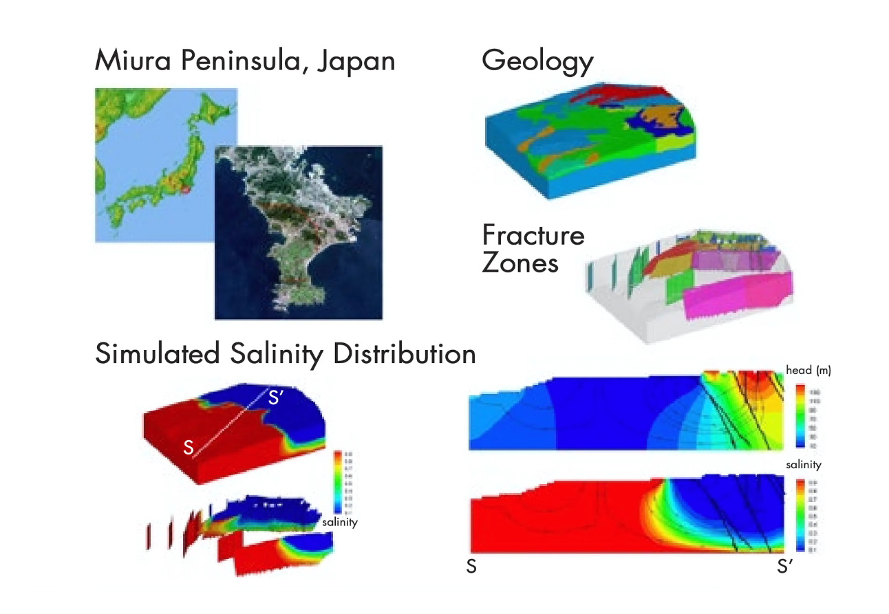
Integrated Hydrologic Analysis for the Miura Coastal Aquifer System
Density-driven groundwater flow plays a critical role for freshwater and sea water interaction in coastal aquifer systems and for both water quantity and quality. An example in Miura Peninsula, Japan, indicates that the location of the interface between freshwater and saline water is determined by multiple factors such as topography, meteorologic driving forces, and subsurface geology.


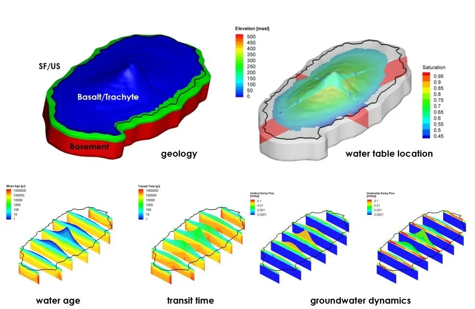
Water Resources Analysis for the Volcanic Island of Jeju, South Korea
Regional scale integrated hydrologic modelling of Jeju Island indicates that there are various groundwater systems with distinct characteristic such as a mountainous recharge system, an active coastal groundwater system, a stable deep freshwater system, and a saline groundwater system. A regional scale integrated groundwater-surface water model can be used to better interpret and manage water resources on the island.

Effects of floodplain shading on hyporheic aquifer temperatures
HydroGeoSphere can be used to simulate water and heat transport in floodplains under variable riparian forest densities. Riparian forests have the potential to mediate atmosphere-aquifer heat exchange by shading the floodplain surface, thereby influencing stream channel temperatures indirectly via hyporheic exchange of water and heat. Model results indicate that shade mediates the warming of hyporheic and channel water. Consideration of floodplain shade management, both during and after restoration actions, may improve outcomes for restoration of stream channel temperatures.

Modeled Salinities In Coastal Aquifers Depend On High- And Low-frequency Fluctuations In Sea Level, Controlled By Storage Properties.
HydroGeoSphere can be used to simulate groundwater flow and salt transport in coastal aquifers under variable sea level conditions. Model results indicate that cyclical sea level fluctuations— from tidal to glacial timescales— can significantly alter average salinity distributions compared to steady-state assumptions. Considering these multi-scale fluctuations during model calibration can improve the accuracy of salinity estimates and support more effective management of vulnerable coastal groundwater resources.


Vulnerability To Sea-level Rise And Storm-surge Salinization Differs For Topography-limited And Recharge-limited Systems: Insights From Groundwater Flow And Transport Modeling At Assateague Island, MD
HydroGeoSphere can be used to assess coastal aquifer vulnerability to sea-level rise and storm-surge overwash. Model results at Assateague Island, MD show that storm-surge frequency poses a greater salinization risk than sea-level rise alone, with recharge-limited systems being especially susceptible over the long term.

Impact Of Ocean Surge Profiles On Overwash-driven Salinization In Coastal Aquifers
HydroGeoSphere can be used to simulate storm-surge-driven salinization of coastal aquifers. Results show that surge profile shape, duration, and regional variations in surge magnitude strongly influence saltwater infiltration and recovery time, with certain surge conditions posing heightened long-term risks to coastal groundwater resources.

-
![A landscape showing a dried, cracked lakebed with a mountain range in the background, overlaid with a warning icon of the Earth with a thermometer indicating high temperatures.]()
Climate Change Impact Analysis
-
![A digital topographic map with green landmasses, blue river channels, and yellow-brown terrain outlines, overlaid with a white gear icon containing a water droplet and a hand.]()
Water Resources Engineering and Consulting
-
![Scenic mountain landscape with snow-capped peaks reflecting in a calm lake, under a clear blue sky.]()
Watershed Management and Decision Support
-
![Open-pit mining quarry with terraced layers of earth and rocks, clear blue sky above.]()
Mine Operations and Closure Planning
-
![Person in a red and black plaid shirt using a tablet in a wheat field, with a white leaf and checkmark eco-friendly logo overlay]()
Agriculture & Forestry
-
![A cooling tower emitting steam at dusk with a large radiation warning symbol overlaid.]()
Nuclear Waste Management
-
![A digital illustration featuring a cloud, a shield with a checkmark, and a network of connections, symbolizing cloud security and protection.]()
Flood and Drought Risk Management, Insurance
-
![An aerial view of a coastal landscape with sandy beaches, grassy patches, and blue ocean waves, with a white overlay icon of a wave inside a circle.]()
Coastal Hydrology, Thermal Energy Transport and Density-Dependent Flow Applications


Connect with Aquanty
Let our experts guide you through our cutting-edge technology and demonstrate how our services can address your specific needs.