
HydroGeoSphere Research Project Featured in Scienmag.
We’re pleased to share that recent research project media highlight using HydroGeoSphere (HGS) to investigate how rewetting propagates through restored peatlands has been featured in Scienmag in the article, “How Far Does Water Travel When Peatlands Are Rewetted? A New Model Reveals the Answer.” The feature highlights research by Omar Ashraf Nimr, Hannu Marttila, Okke Batelaan, Daniel Partington, and Pertti Ala-Aho, examining how different peatland restoration interventions influence water-table recovery across a boreal fen in northern Finland.
HGS RESEARCH HIGHLIGHT – Discharge-Targeted Hydraulic Tomography to Quantify and Locate Aquifer Discharge
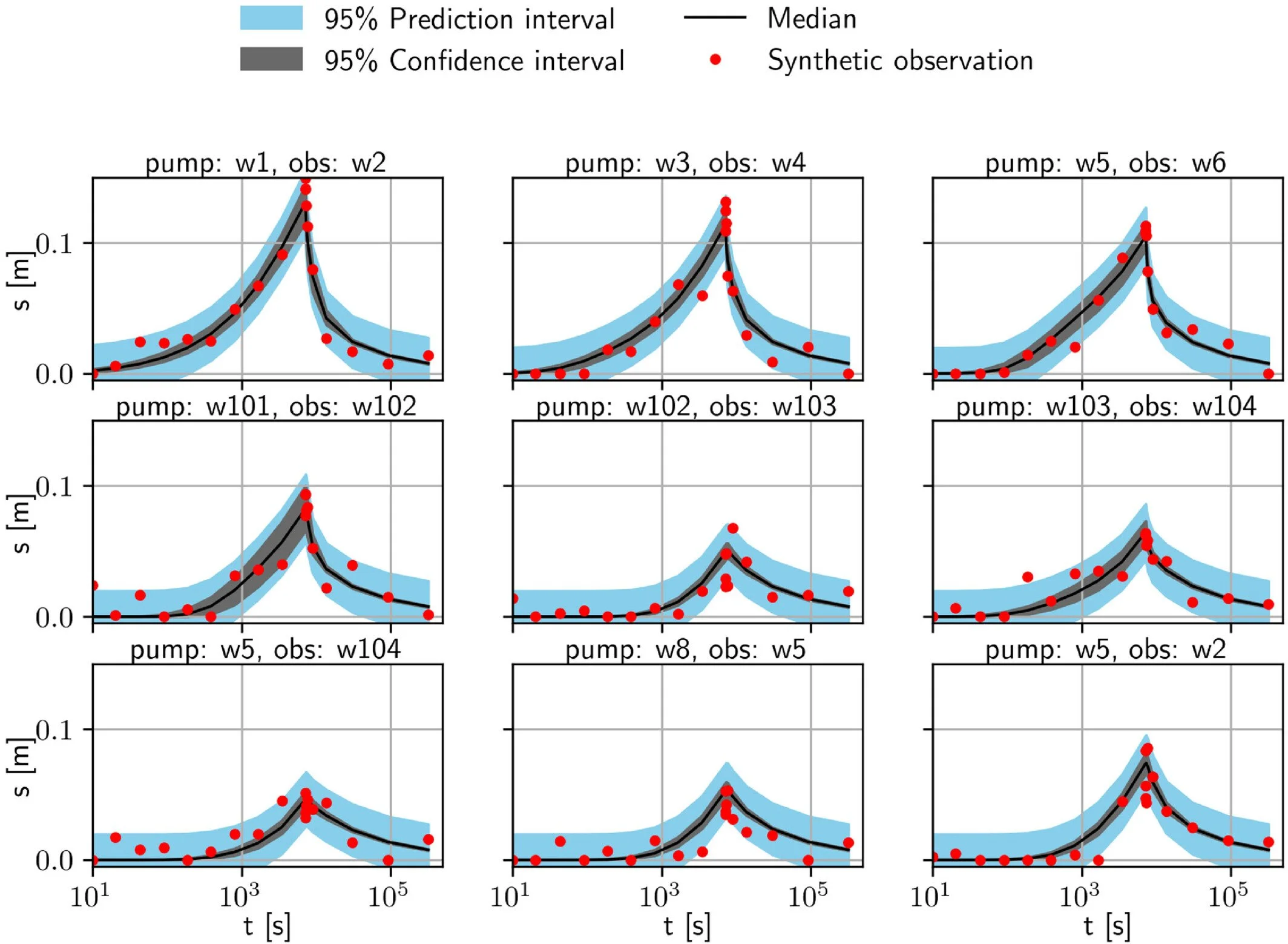
We're pleased to highlight this publication by Konstantin Drach, Carsten Leven, and Olaf A. Cirpka, which introduces a novel Discharge-Targeted Hydraulic Tomography (DTHT) approach for quantifying and locating groundwater discharge in heterogeneous aquifers. Using HydroGeoSphere (HGS), the researchers demonstrated how strategically placed pumping and observation wells can provide more accurate estimates of groundwater discharge and identify preferential flow zones than conventional pumping test analyses.
HGS RESEARCH HIGHLIGHT – Impact of River Morphology on River–Groundwater Exchange in Braided River Systems
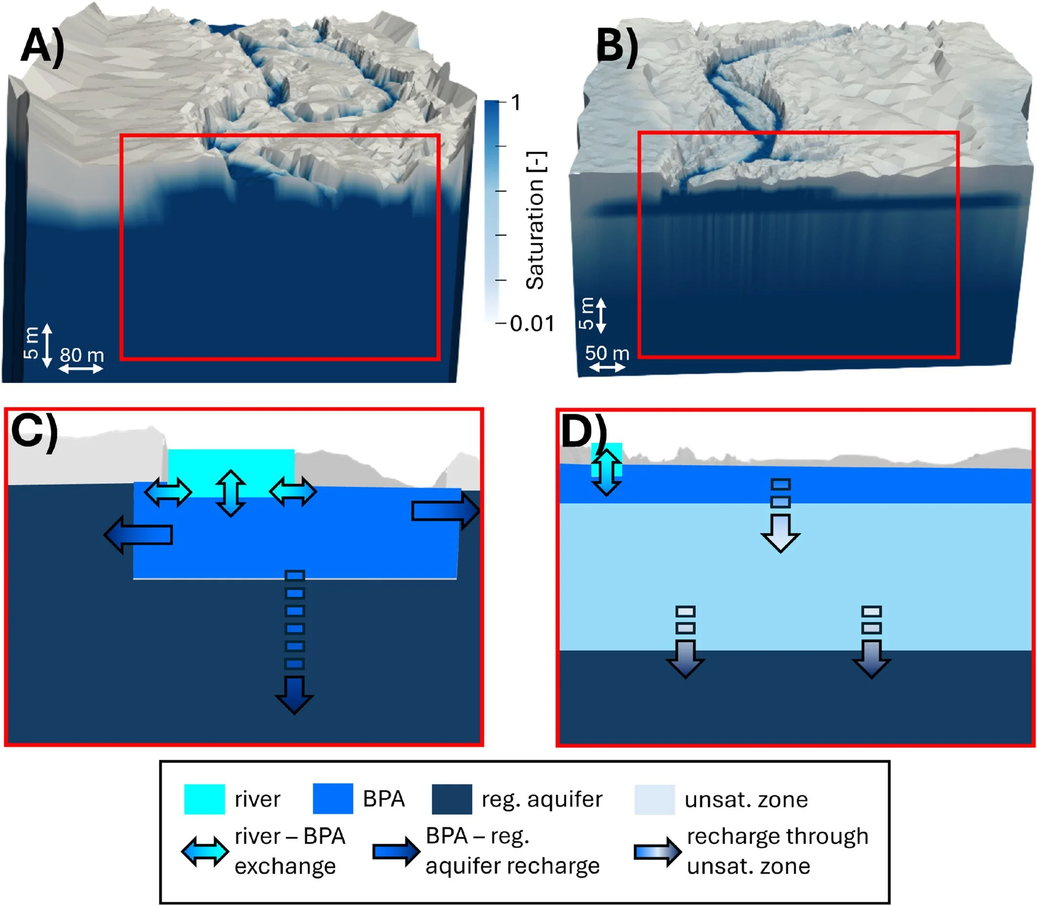
We're pleased to highlight this publication by Thomas Wöhling, Moritz Kraft and Antoine Di Ciacca, which investigates how flood-driven changes in braided river morphology influence river–groundwater exchange and aquifer recharge. Using HydroGeoSphere (HGS), the researchers developed fully coupled surface water–groundwater models of two braided river systems in New Zealand to isolate the effects of changing riverbed morphology before and after major flood events. The study demonstrates that morphological changes alone can significantly alter both recharge to shallow braidplain aquifers and subsequent recharge to regional groundwater systems.

Staff Research Highlight - Water Balance and Flow Tracer Application Using a Fully Integrated Hydrologic Model in a Pilot-scale Oil Sands Pit Lake Catchment
We're pleased to highlight this new publication by Aquanty staff, including Arghavan Tafvizi, James Ehrman, Ali Sharifinejad, Diana Zhang, Michael Callaghan, Steven Berg and Killian Miller, along with our collaborators at Suncor Energy Mike Wang, and Xiaoying Fan. This paper demonstrates the use of HydroGeoSphere (HGS) and the Hydraulic Mixing Cell (HMC) method to better understand water movement within a constructed end pit lake watershed. Using the Lake Miwasin Watershed in northern Alberta as a pilot-scale study site, the researchers developed and calibrated an integrated hydrologic model to simulate surface water, groundwater, lake levels, and evapotranspiration, while using HMC to identify how different areas of the watershed contribute to lake inflow under changing seasonal and climatic conditions.
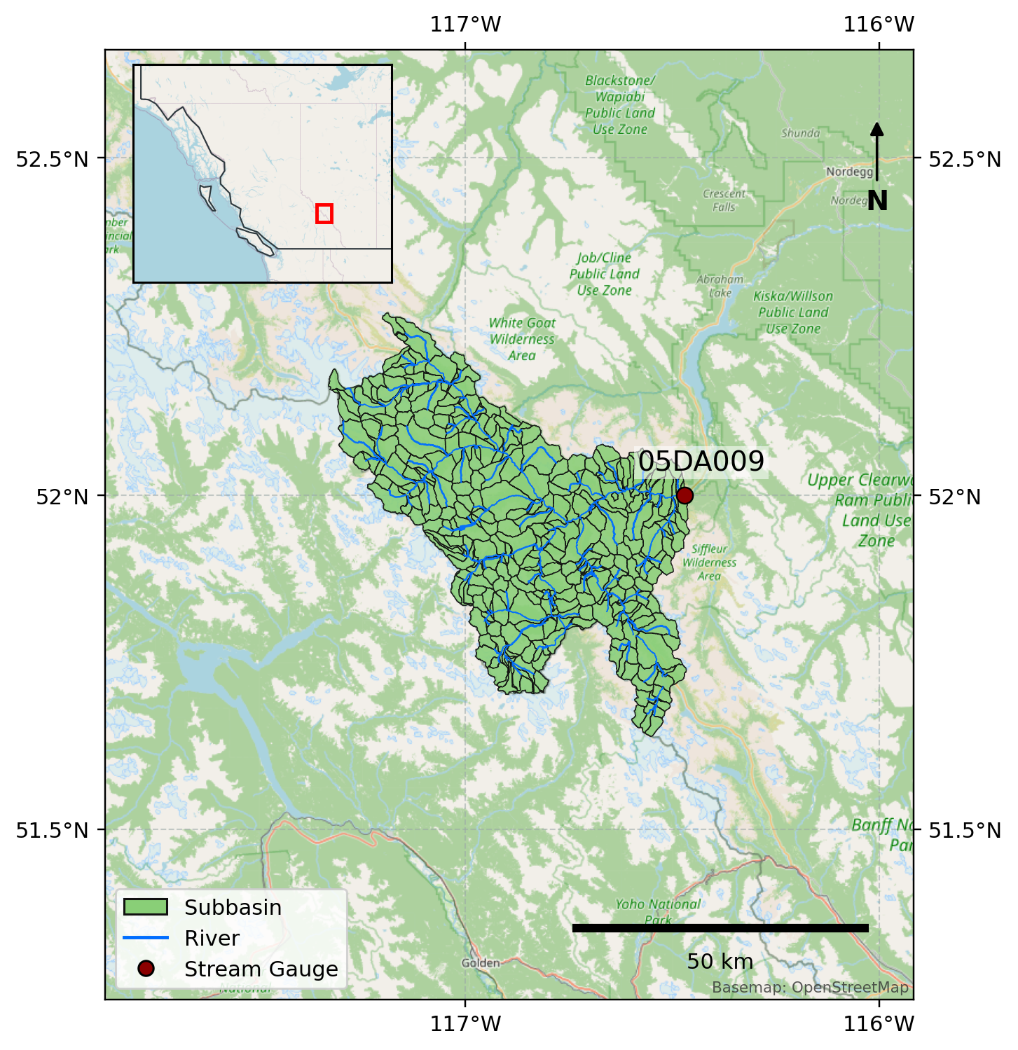
Delta-Models for Reservoir Operations – NORTH SASKATCHEWAN RIVER AT WHIRLPOOL POINT (05DA009)
The Bighorn dam is located in the foothills of the Canadian Rockies in Alberta and is one of TransAlta's major hydroelectric facilities, with a capacity of 120 MW and an average annual generation of approximately 408,000 MWh (Bighorn - TransAlta). Reservoir planning is important for hydropower operations because operators must balance water availability, storage constraints, generation demand, flood risk, and downstream flow requirements. In snowmelt dominated basins (like this one), reservoir inflow relies on both current streamflow and upstream watershed conditions which determine future water volumes over coming days, weeks, and months. These conditions include the amount of water stored as snowpack, the timing/rate of snowmelt, antecedent soil wetness, incoming precipitation, and changes in temperature.
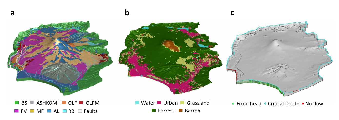
HGS RESEARCH HIGHLIGHT – Modeling a geologically complex volcanic watershed for integrated water resources management in Mt. Fuji, Japan
This publication presents a three-dimensional geological and integrated hydrological modelling dataset developed for the Mt. Fuji volcanic watershed in Japan. This study leverages HydroGeoSphere (HGS) to simulate coupled surface–subsurface flow and transport processes in a geologically complex volcanic catchment, addressing long-standing challenges in representing groundwater flow pathways and hydrologic interactions in structurally heterogeneous mountain environments. The resulting dataset provides a physically consistent modelling framework to support interdisciplinary water resources research and scenario-based hydrologic simulations.
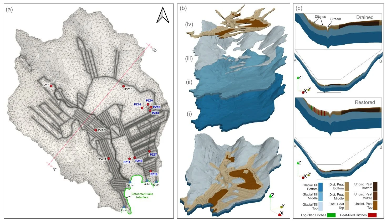
HGS RESEARCH HIGHLIGHT – How Does Rewetting Propagate Through Restored Peatlands? An Integrated Surface–subsurface Modelling Analysis of Water–table Dynamics
We’re pleased to highlight this publication, which investigates how peatland restoration alters groundwater table dynamics across drained boreal peatlands using fully integrated hydrologic modelling. This study leverages HydroGeoSphere (HGS) to simulate coupled surface–subsurface flow processes and evaluate spatial patterns of groundwater response following ditch blocking and rewetting interventions, addressing long-standing challenges in predicting restoration outcomes across heterogeneous peatland landscapes.
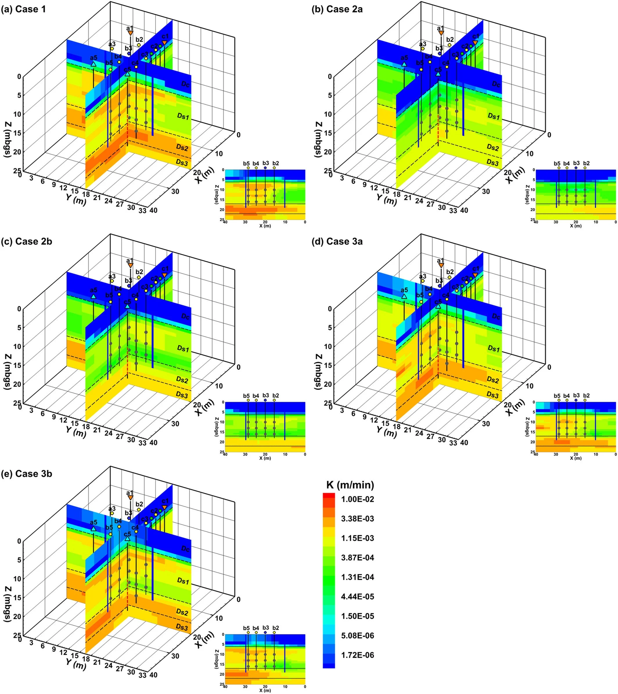
HGS RESEARCH HIGHLIGHT – Three‐Dimensional Geostatistical Inverse Analyses of Transient Head and Temperature Data From a Long‐Term Heat Tracer Test
We’re pleased to highlight this staff research highlighted which investigates how three-dimensional geostatistical inverse modelling can improve characterization of subsurface heterogeneity in groundwater systems. This study leverages HydroGeoSphere (HGS) to simulate fully coupled groundwater flow and transport processes within a stochastic inversion framework, addressing long-standing challenges in estimating spatially distributed hydraulic conductivity fields from limited observational data.
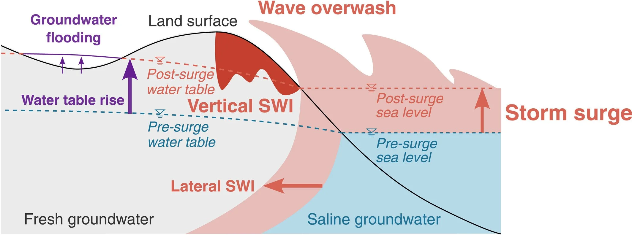
HGS RESEARCH HIGHLIGHT – Climate Change Alters Post-Surge Recovery of Coastal Aquifers
This publication co-authored by Satoshi Tajima, René Therrien and Philip Brunner investigates how climate change influences the recovery of coastal aquifers following storm surge events. This study leverages HydroGeoSphere (HGS) to simulate coupled groundwater flow and variable-density salt transport, addressing long-standing challenges in understanding how coastal aquifers respond to storm-driven seawater intrusion and how recovery dynamics may change under future climatic conditions.
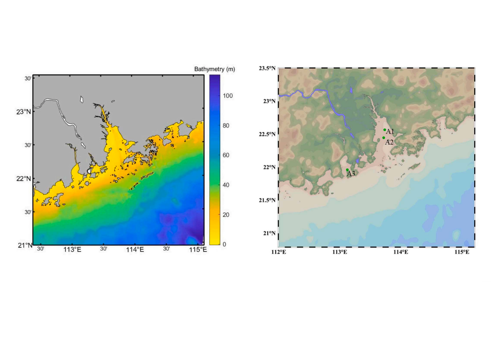
HGS RESEARCH HIGHLIGHT – Modeling the water use associated with energy consumption changes on saltwater intrusion in the Pearl River estuary, China
This research investigates how increased energy consumption and associated changes in water use impact saltwater intrusion in the Pearl River Estuary— one of China's most economically vital and environmentally vulnerable regions.