
HGS RESEARCH HIGHLIGHT – Modeling a geologically complex volcanic watershed for integrated water resources management in Mt. Fuji, Japan

Musy, S. L., Dresmann, H., Tomonaga, Y., Sano, Y., & Schilling, O. S. (2025). Modeling a geologically complex volcanic watershed for integrated water resources management in Mt. Fuji, Japan. Scientific Data, 13 (1). https://doi.org/10.1038/s41597-025-06380-z
“Although HGS supports both finite element and finite difference methods, the present model was developed using the finite element approach. Accordingly, mesh generation was carried out with the finite element mesh generation software AlgoMesh using line and polygon vector files as input. The catchment contours, resampled at a 400 m resolution, define the outer extent of the mesh.”
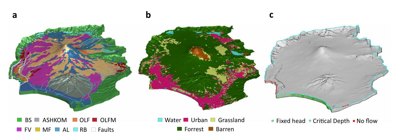
Fig. 4. Set up for the integrated hydrogeological model of Mt. Fuji catchment (Japan); (a) Elemental zones in the porous medium domain, corresponding to the different hydrofacies in Table 1, as well as the lake and riverbeds (RB) and fault elements, corresponding to the lake and river beds, resp. to the fault zone; (b) Elemental zones for the overland flow domain, corresponding to the categories in Table 3; (c) Model boundary conditions: blue diamonds represent the critical depth boundary conditions for the surface domain in the Suruga Bay area, on the river outflows and on the catchment contours. The Fuji River Termination (SW) and Kise River effluent (SE) are set to no-flow boundary conditions (red spheres). The green boxes represent the fixed head for the subsurface domain in the Suruga bay area, and to the river elevation in the North and East outlets (not visible from this point of view). For the lateral subsurface boundaries for which no other boundary conditions are indicated, as well as for the base of the model, no flow conditions were imposed (not shown).
This publication presents a three-dimensional geological and integrated hydrological modelling dataset developed for the Mt. Fuji volcanic watershed in Japan. This study leverages HydroGeoSphere (HGS) to simulate coupled surface–subsurface flow and transport processes in a geologically complex volcanic catchment, addressing long-standing challenges in representing groundwater flow pathways and hydrologic interactions in structurally heterogeneous mountain environments. The resulting dataset provides a physically consistent modelling framework to support interdisciplinary water resources research and scenario-based hydrologic simulations.
Hydrologic analyses in volcanic terrains are often limited by sparse subsurface observations and simplified conceptual representations of hydrofacies structure. While geological datasets and monitoring networks provide valuable constraints, they rarely capture the full complexity of fractured volcanic aquifers and fault-controlled flow systems. By integrating stratigraphic interpretation, hydrofacies mapping, land-cover parameterization, and numerical mesh development within a HydroGeoSphere modelling workflow, this research establishes a catchment-scale framework capable of representing interactions between surface water, groundwater, and vegetation processes under realistic boundary conditions.
The study applied the HGS model to the Mt. Fuji watershed using a structured workflow that combined geological cross-sections, borehole data, hydrofacies surfaces, and land-use datasets to construct a three-dimensional representation of subsurface structure and hydrologic properties. Simulations successfully reproduced major surface-water features while capturing groundwater flow behaviour across contrasting aquifer thicknesses separated by regional fault systems. Results demonstrated that even a computationally efficient model configuration could reproduce realistic hydrologic system behaviour while supporting sensitivity analyses and scenario-based simulations for future research applications.
Key findings showed that integrated geological–hydrological modelling provides a robust foundation for evaluating groundwater dynamics in volcanic catchments, where structural uncertainty and limited calibration data often restrict predictive modelling efforts. The dataset enables further investigation of fault-controlled flow discontinuities, hydrofacies uncertainty, and climate-driven hydrologic variability within a unified modelling framework designed for extension through automated calibration and scenario testing.
HydroGeoSphere proved essential in enabling this work due to its ability to simulate fully integrated surface flow, variably saturated subsurface flow, discrete fracture flow, vegetation–land–water interactions, density-dependent transport, and winter hydrological processes within a single modelling platform. These capabilities allowed the researchers to construct a catchment-scale representation of the Mt. Fuji hydrologic system that captures the multi-process complexity characteristic of volcanic watersheds.
This research provides critical insights for integrated watershed modelling and groundwater resource assessment in geologically complex regions, demonstrating that advanced modelling approaches like HydroGeoSphere can support the development of reproducible, extensible hydrologic datasets for interdisciplinary research and long-term water management planning.
Abstract:
This dataset provides high-resolution 3D geological and integrated hydrological models of Mt. Fuji watershed in Japan. The watershed’s complex volcanic and tectonic setting, large spatial extent, and limited subsurface data present significant challenges for integrated hydrological modeling. Diverse geological datasets – borehole logs, geological maps, and hydrofacies surfaces – were collected, processed, and used to construct and validate a 3D geological model suitable for integrated hydrological simulations. Building on this, a 3D numerical model for integrated hydrological simulations was constructed. The repository includes 3D hydrofacies surfaces in raster format, numerical mesh files, and input configurations necessary to run simulations with the integrated surface-subsurface hydrological simulator HydroGeoSphere. The preparation of heterogeneous geological data, construction of hydrofacies surfaces, generation of the numerical mesh, and setup of the integrated hydrological model are described in a streamlined, reproducible workflow suited for volcanic contexts and transferable to other geologically complex or data-limited regions. These resources are intended to reduce trial-and-error iterations and support further research in groundwater assessment, model calibration, climate impact studies, and hazard mitigation.