
HGS RESEARCH HIGHLIGHT – Mine rock stockpile reclamation trial, Detour Lake Mine

Harrington, J. S.; Mendoza, C. A.; Straker, J.; Baker, T.; McMahen, K.; Raizman, V.; Lyle, K. (2022). Mine rock stockpile reclamation trial, Detour Lake Mine : Initial geotechnical, ecological, and hydrological performance. Open Collection from the British Columbia Mine Reclamation Symposium, http://hdl.handle.net/2429/83132
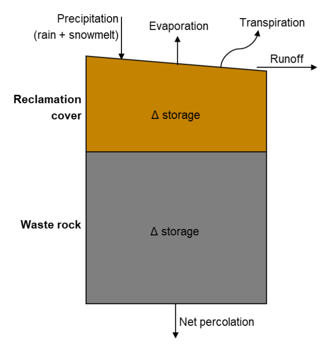
Conceptual hydrologic model for reclamation cover overlying waste rock
HydroGeoSphere is a powerful tool for evaluating the hydrology of open pit mining operations. HGS modelling at mine sites is typically at the site scale, and presents a perfect use case for short-term real-time hydrologic forecasting. But HGS can also be used at smaller scales (i.e. 1D column models, or 2D cross sectional models)
In this study, a series of reclamation cover configurations were evaluated based on 13 large test plots with a single-layer isolation cover made of abundant local overburden material. On each plot the test cover was slightly different, in order to test the impact of slope angle (flat to 36°), aspect (North through East facing), cover thickness (0.3m - 1.0m, with some tests with no cover), surface grading techniques, and with various types of vegetation/seeding methods.
The authors use 1D column HGS models to evaluate the hydrology of a simple, unengineered reclamation cover overlying mine waste rock from the Detour Lake Mine in Northern Ontario. 2D cross sectional HGS models were also constructed to ensure the 1D column models were producing accurate results. Model results suggest that the reclamation cover reduces net percolation into waste rock compared to uncovered waste rock, largely by storing water that can subsequently evaporate or transpire.
The ability to model three-dimensional unsaturated flow, overland runoff and evapotranspiration in a single integrated and tightly coupled model is unique to HydroGeoSphere, which makes it the perfect tool for modelling mine waste rock hydrology.
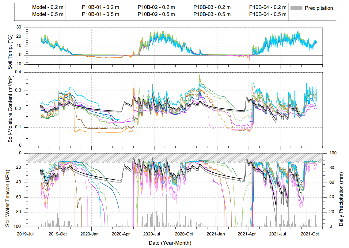
Soil temperature, soil-moisture content, and soil-water tension data from Plot 10B (0.7 m thick cover) compared with hydrologic modelling results for a 0.7 m thick cover (heavy black and grey lines represent model results).
Abstract:
Guidance for beneficial strategies for landform design and progressive reclamation is being developed at Detour Lake Mine (northern Ontario) by monitoring and evaluating the large-scale, 10-ha Test Cover Trial on a mine rock stockpile. The design and construction of the Test Cover Trial are described in the companion paper by Cash et al., which comprises a reclamation cover placed on 13 different trial plots with varying slope angle, aspect, cover thickness, surface grading, and revegetation prescription. This paper describes preliminary results from monitoring that is ongoing to evaluate the geotechnical, ecological, and hydrological performance of the Test Cover Trial and the relative performance of different cover treatments. Site visits are used to record geotechnical, ecological, and hydrological observations. Instrumentation includes a meteorological station and multi-level installations of soil-moisture sensors. Monitoring data are used for numerical modelling of the reclamation cover hydrological regime.
To date, large-scale slope instabilities have not been observed in the reclamation cover, contrary to expectations. Most erosion and related deposition of reclamation cover material occurred over the first year following construction. There are appreciable differences in performance between different trial plots. Plots with the steepest and shallowest slope angles, the thinnest cover, or corrugated surface grading exhibit the most erosion. Vegetation survival is correlated with surface grading, cover bulk density, peat content, and slope aspect. Vegetation is becoming established in erosional rills and gullies and on some depositional fans. Instrumentation data indicate that the reclamation cover generally remains unsaturated. Preliminary hydrologic modelling indicates that the reclamation cover decreases net percolation and sensitivity analyses suggest that net percolation may vary due to climate and vegetation effects. Overall, the geotechnical performance of many cover treatments is exceeding expectations, vegetation performance is different than expected due to appreciable plant removal by birds, and hydrological performance is similar to design expectations.