
HGS RESEARCH HIGHLIGHT – Reclamation for aspen revegetation in the Athabasca oil sands: Understanding soil water dynamics

Carrera-Hernández, J. J., Mendoza, C. A., Devito, K. J., Petrone, R. M., & Smerdon, B. D. (2012). Reclamation for aspen revegetation in the Athabasca oil sands: Understanding soil water dynamics through unsaturated flow modelling. In Canadian Journal of Soil Science (Vol. 92, Issue 1, pp. 103–116). Canadian Science Publishing. https://doi.org/10.4141/cjss2010-035
“For the virtual experiments developed in this work, the adaptive time step option of HydroGeoSphere was used. The output was processed through a series of awk scripts to get daily and/or monthly data, because for some days HydroGeoSphere required 50 or even more subdaily time steps to converge.”

Figure 1. Location of the oil sands regions and the boreal plains within the Canadian boreal forest, with disturbance in the Athabasca region illustrated through the use of a LANDSAT-5 colour composite for (a) August 1985 and (b) September 2010 with coordinates given in meters, UTM-12. The Alberta inset shows the Utikuma Region Study Area (URSA) where evapotranspiration data for aspen were measured.
CLICK HERE TO READ THE ARTICLE.
We’re pleased to highlight this older publication authored by researchers at the University of Alberta, Wilfred Laurier University and the Commonwealth Scientific and Industrial Research Organisation (CSIRO). The paper focuses on understanding soil water dynamics in reclaimed landscapes within the Athabasca oil sands region using unsaturated flow modelling. The study explores how different reclamation strategies affect soil water availability and water table fluxes— critical components for supporting aspen revegetation, a key species in boreal forest ecosystems.
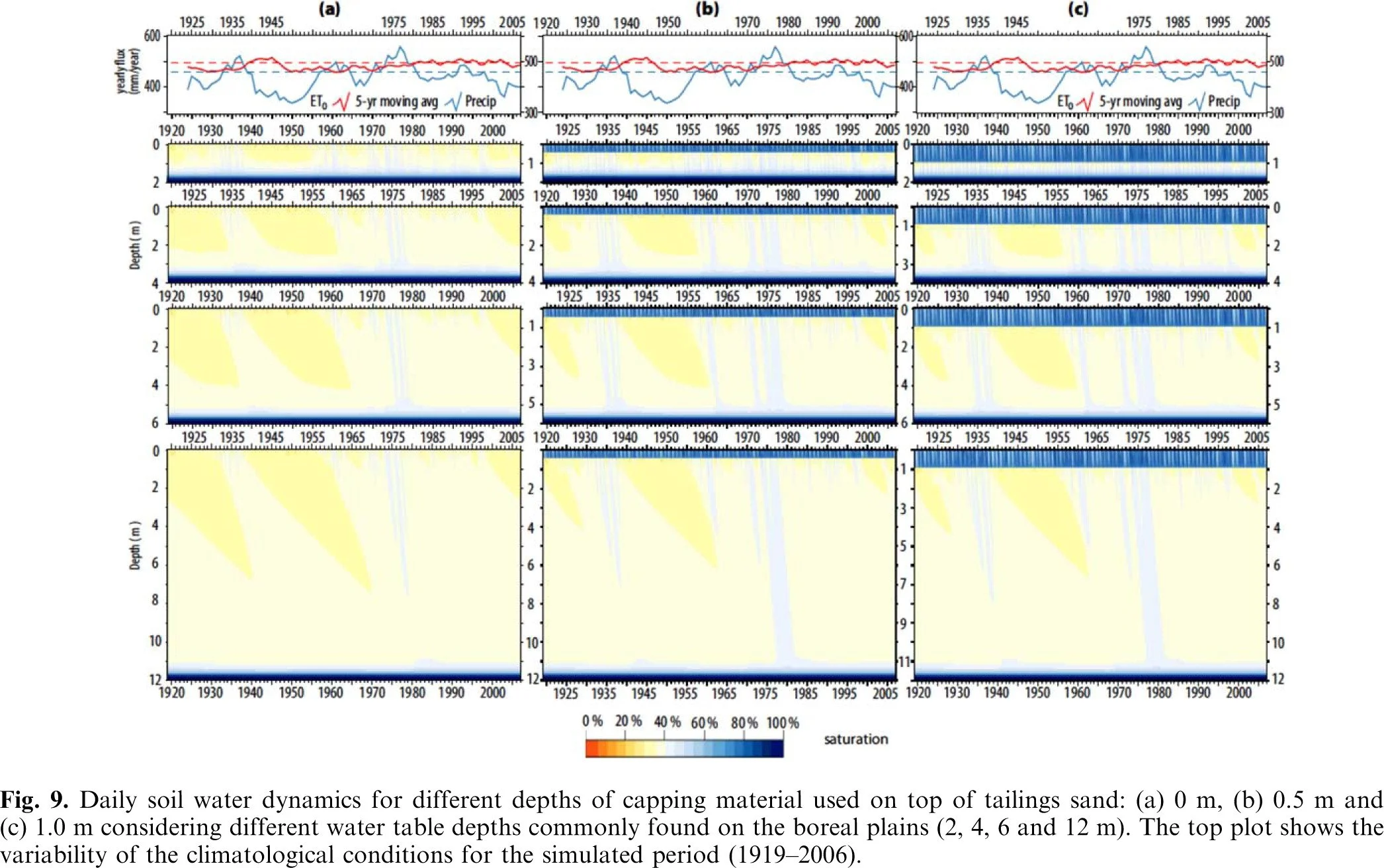
Figure 9. Daily soil water dynamics for different depths of capping material used on top of tailings sand: (a) 0 m, (b) 0.5 m and (c) 1.0 m considering different water table depths commonly found on the boreal plains (2, 4, 6 and 12 m). The top plot shows the variability of the climatological conditions for the simulated period (1919–2006).
In this research, HydroGeoSphere (HGS) was used to simulate soil water movement under various reclamation scenarios over an extended period (1919–2006), integrating long-term climate variability into the analysis. The study tested combinations of reclamation cover thicknesses (0.0, 0.5, and 1.0 m) and water table depths (2, 4, 6, and 12 m) to determine the conditions most suitable for sustaining vegetation, particularly trembling aspen, in reconstructed post-mining landscapes. The virtual experiments captured daily soil moisture profiles and fluxes at the water table, offering a realistic representation of hydrological processes over both wet and dry climate cycles.
HydroGeoSphere’s robust modelling framework allowed for a fully integrated simulation of variably saturated flow under each reclamation scenario. The model incorporated adaptive time-stepping and dynamic boundary conditions, such as net atmospheric fluxes derived from evapotranspiration and precipitation data. Importantly, the simulations demonstrated how the presence of a reclamation cover— especially with a thickness of 0.5 to 1.0 m— could buffer against moisture loss and promote water retention, making it more available to support plant growth.
Results showed that reclaimed landscapes generally experienced less fluctuation in water table fluxes compared to natural settings. The addition of fine-textured reclamation material helped moderate water movement and created more stable conditions for vegetation establishment. Notably, upward flux from the water table— critical during dry periods— was only significant in scenarios with shallow water tables (2 m) and adequate reclamation cover. This highlights the importance of maintaining a water table depth of at least 4 m in order to minimize the risk of salinity impacts from upward groundwater flow, especially during prolonged dry cycles.
By using HydroGeoSphere to analyze these complex interactions over decades of climate variability, the study provides valuable guidance for designing effective reclamation strategies in oil sands regions. The findings emphasize the importance of soil texture, cover thickness, and water table depth in developing sustainable post-mining landscapes that can support long-term forest regeneration and minimize ecological disturbance.
Abstract:
Reclamation of mined areas in the Athabasca oil sands region is required by law, with the ultimate goal of revegetating to species characteristic of predisturbance native plant communities. To develop adequate reclamation strategies, an analysis of soil water dynamics is of utmost importance, as is understanding the impact of the thickness of the reclamation cover. In this work, soil water dynamics and fluxes at the water table were simulated for three reclamation scenarios and compared with the fluxes obtained for natural conditions assuming that aspen is the target reclamation species. According to the simulations, a reclamation thickness between 0.5 and 1.0 m can be used to provide water for revegetation. The numerical simulations show that the reclaimed landscapes have fluxes at the water table that exhibit less fluctuation than natural conditions. To limit the interaction between the water table and atmospheric fluxes, and to limit upward flux, the water table should be deeper than 2.0 m on reclaimed landscapes that use aspen for revegetation, particularly when reclamation takes place during a dry climatological cycle.