
HydroSphereAI Case Study: Wakeman River
During October and November 2025, a series of back-to-back Pacific storm systems brought steady rainfall across the central coast of British Columbia. Such events are a common occurrence in the Pacific Northwest and are intensifying in a warmer climate. Major Atmospheric River events, such as the 2021 “Pineapple Express” and recent rainfalls in December 2025, can cause significant flooding and infrastructure damage. In many cases, impacts are exacerbated by limited forecast lead time and an unclear picture of the hydrological response.
Forecasting such extreme events can be very challenging and actual intensities are often not fully captured, thus leading to underestimation of the hydrological response (as was the case in December). The weather systems before the recent intense rainfalls were relatively well predicted and therefore present an opportunity to evaluate how HydroSphereAI (HSAI) performs in predicting the hydrological response during repeated high-rainfall events in a small, fast-responding watershed like the Wakeman River.
Over the two-month period, Aquanty’s HydroSphereAI (HSAI) forecasted several distinct high-flow responses connected to each passing storm. The most notable peaks occurred around:
October 24
October 29
November 1
November 6-7
November 10
November 17
Across all of these events, the platform generally captured the timing of rising flows well, and forecasts became more accurate as the events approached. This was enabled by relatively skillful weather forecasts for most of these events, so that the predicted hydrological response can be evaluated.
Early Forecast Signals
When the first major system approached in late October, HydroSphereAI began predicting rising flows several days in advance. Prediction of such events at longer lead times (1-2 weeks) is challenging, because there is still considerable uncertainty about the intensity and timing of storm events and where the frontal system will hit the coast. Therefore, at longer lead times, the ensemble spread is still wide, but probabilistic ensemble forecasts can already provide advanced warning that a substantial rise in flow levels is possible.
A similar pattern continued through the rest of the storm sequence – HydroSphereAI identified early indications of elevated flows and gradually refined the predictions as each storm event drew nearer.
Forecast Refinement as Events Approached
A consistent trend across all five storm events was how the forecast ensemble spread naturally tightened as the peak flow dates approached. For each high-flow event:
Early forecasts showed a broad spread, but correctly showed that a noticeable rise was likely.
As the event drew closer, the system’s trained AI algorithm produced increasingly focused predictions.
Within roughly 24–48 hours of each peak, the ensemble members converged closely around what the observed hydrograph ultimately showed.
Taken together, HSAI can provide probabilistic advance notice (up to 1-2 weeks ahead) of the potential for major flood events, allowing authorities to issue watches and warnings, while relatively accurate forecasts of expected peak flows and timing are available a few days in advance, to guide emergency preparedness measures.
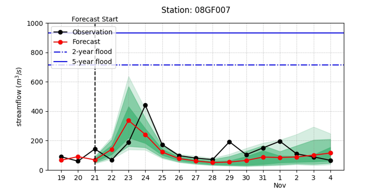
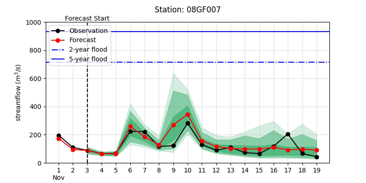
Capturing Timing and River Response
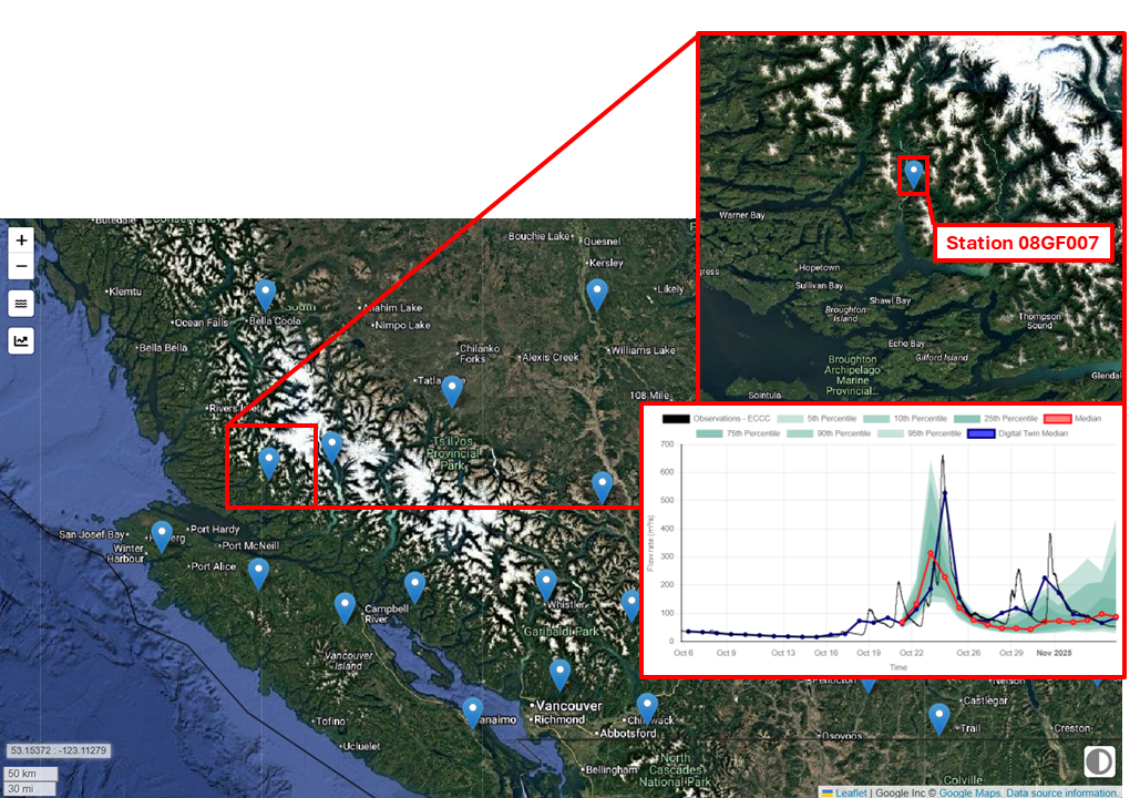
The Wakeman River (Station 08GF007) is located on the central coast of British Columbia.
Across all five storm-driven events, HydroSphereAI performed well in reproducing key features of the hydrological response in the Wakeman River including; the start of the rising limb, the timing of each peak flow, differences in magnitude between events, and fast recessions typical of steep coastal rivers.
Although the median forecast was occasionally slightly above or below observed values, the observations almost always remained within the ensemble envelope, an important characteristic for communicating uncertainty.
Why These Storms Matter for Evaluating System Performance
While the events of October and November did not reach major flood levels, they represent the most common high-flow scenarios, and therefore provided an excellent evaluation scenario under typical operational conditions. In addition, the weather systems were relatively well predicted, which allows us to evaluate the hydrological response predicted by HSAI.
The key takeaways include:
Predictions sharpened consistently as the timing of each storm became clearer.
Strong medium-range awareness, with HydroSphereAI showing the likelihood of elevated flows several days out.
Reliable performance across multiple consecutive peaks, demonstrating stability under varying storm intensities.
Realistic ensemble behaviour, with uncertainty narrowing appropriately as lead times shortened.
Conclusion
The Wakeman River is representative of many small, steep coastal and alpine watersheds across British Columbia. The October–November 2025 storm sequence offered a clear demonstration of HydroSphereAI’s ability to predict repeated high-flow events in this typical coastal BC fall-season setting. Across six separate peaks, the system provided early indications of elevated flow periods, produced more focused forecasts as events approached, and tracked observed hydrographs closely during peak flows.
While these events were not extreme floods, they highlight how HydroSphereAI can support water managers, operators, and planners who benefit from dependable short-term and medium-range flow predictions— particularly in remote, fast-responding basins. As storm patterns along the BC coast continue to shift in a warming climate, tools that provide reliable, scenario-aware forecasts are becoming increasingly important for day-to-day decision-making.
It is also important to note that Aquanty continues to develop and improve the predictive skill of HSAI. Having now clearly recognized the importance of accurate weather forecasting when trying to predict hydrologic behavior, the next advancement in the HSAI platform incorporates emerging AI-based weather forecast products (e.g. from the European Centre for Medium-range Weather Forecasts) to even further improve the skill of HSAI. Thus ensuring that HSAI users continue to have the most advanced flow forecasting tools at their disposal.