
HGS RESEARCH HIGHLIGHT – Characterizing Spatial Heterogeneity of Hydraulic Conductivity Using Borehole NMR in a Complex Groundwater Flow System

Wang, C., Steelman, C. M., & Illman, W. A. (2025). Characterizing Spatial Heterogeneity of Hydraulic Conductivity Using Borehole NMR in a Complex Groundwater Flow System. Water Resources Research, 61(10). https://doi.org/10.1029/2024wr039717
“To assess the representativeness of various spatial K models, a numerical groundwater flow simulation was conducted using an integrated hydrologic modeling simulator, HydroGeoSphere.”
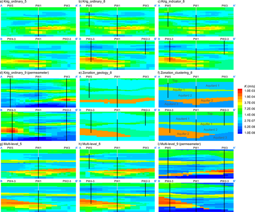
Fig. 5. Contour plots of K distribution in A‐A′ and B‐B′ sections based on comparative cases of spatial modeling, including (a) Krig_ordinary_5: the ordinary kriging using five nuclear magnetic resonance (NMR) logs, (b) Krig_ordinary_8: the ordinary kriging using eight NMR logs, (c) Krig_indicator_8: the indicator kriging using eight NMR logs, (d) Krig_ordinary_9 (permeameter): the ordinary kriging using nine boreholes of permeameter measurements, (e) Zonation_geology_8: the visually‐interpreted geological zonation using eight NMR logs, (f) Zonation_clustering_8: the spatially associated zonation with clustering using eight NMR logs, (g) Multi‐level_5: the multi‐level heterogeneity characterization using five NMR logs, (h) Multi‐level_8: the multi‐level heterogeneity characterization using eight NMR logs, and (i) Multi‐level_9 (permeameter): the multi‐level heterogeneity characterization using nine boreholes of permeameter measurements. Six aquifer and aquitard layers obtained by clustering NMR logs are labeled in part (f). Logging depths of borehole NMR and core sampling for permeameter tests are indicated in these cross‐sections using black lines.
CLICK HERE TO READ THE ARTICLE.
This research highlight co-authored by Chenxi Wang, Colby M. Steelman, and Walter A. Illman, investigates how borehole nuclear magnetic resonance (NMR) logging can be used to characterize subsurface heterogeneity and improve the representation of hydraulic conductivity in groundwater flow models. This study leverages HydroGeoSphere (HGS) to evaluate the predictive performance of NMR-derived hydraulic conductivity (K) models and assess how different spatial interpolation and upscaling approaches influence flow and drawdown predictions in a highly heterogeneous aquifer system.
Traditional aquifer characterization methods often struggle to capture sub-meter scale variations in K and accurately represent layered aquifer–aquitard systems. While borehole NMR provides high-resolution hydraulic property data along individual wells, translating these localized measurements into realistic three-dimensional conductivity fields remains challenging. By integrating NMR-derived K profiles with geostatistical and clustering-based spatial modelling approaches— including kriging, zonation, and a new multi-level heterogeneity framework— this research bridges the gap between detailed borehole data and field-scale groundwater models.
The study applied these methods to the University of Waterloo’s North Campus Research Site, where multiple pumping and injection tests were conducted to evaluate model performance. Using HGS, the researchers simulated coupled groundwater flow under transient conditions to compare different heterogeneity representations. Results showed that models incorporating both zonal and intralayer variability achieved the closest match to observed drawdown data, outperforming traditional kriging approaches. The new multi-level framework also maintained strong predictive skill even with limited NMR data, demonstrating robustness across varying data densities.
Key findings showed that HydroGeoSphere was essential for validating the NMR-derived models, as it allowed for realistic representation of head–flux relationships within complex, heterogeneous aquifers. By capturing how hydraulic heterogeneity controls flow connectivity and pressure response, HGS provided the physical basis to evaluate and refine simplified spatial models.
Fig. 7. Comparison of K in PW3 between the model‐derived K based on nuclear magnetic resonance logging and the permeameter K measurements. (a) Is the K profiles along PW3, in which the locations of Aquifer 1 and Aquifer 2 are labeled. (b)–(f) Are the scatterplots of model‐derived K versus permeameter K measurements using five spatial interpolation methods. The black dashed lines are the 1:1 lines indicating the perfect match, while the red dashed lines indicate the range in which the model fit is within one order of magnitude.
This research provides critical insights for hydrogeological modelling and site characterization, showing that advanced, physics-based tools like HydroGeoSphere can be used in combination with NMR logging to resolve fine-scale heterogeneity and improve groundwater flow predictions. By coupling geophysical data with integrated hydrologic modelling, the study paves the way for more accurate and efficient approaches to groundwater resource assessment and management.
Abstract:
Borehole nuclear magnetic resonance (NMR) logging can yield estimates of hydraulic conductivity (K) in unconsolidated sediments. Previous studies focused on establishing petrophysical models relating NMR responses to K and calibrating model constants for optimized K estimation. However, research has yet to explore the potential of NMR logging to derive spatial K distributions, which would enable its utilization in numerical groundwater flow and transport models. In this study, we construct various spatial K models based on NMR logging data. Characterization of spatial heterogeneity between NMR logs is explored using: (a) geostatistical interpolation approaches, including ordinary kriging and indicator kriging, (b) a zonation approach using clustering with spatial constraints for improved extraction of zone geometry, and (c) a hybrid model of multi‐level spatial heterogeneity nesting a zonal representation with zonally kriged K. The representativeness of NMR‐derived spatial K models is evaluated by reproducing a permeameter‐based K profile at an unsampled location and by comparing the numerically simulated drawdown responses with field observations of ten pumping tests. Results reveal that the spatially associated zonation model can effectively represent the K patterns between boreholes. Incorporating intralayer heterogeneity further refines the characterization of K heterogeneity, achieving optimal drawdown predictions. More importantly, its drawdown prediction performance remains stable with a limited NMR data set. This study provides a framework for using high‐resolution NMR‐derived K profiles from multiple boreholes to characterize spatial heterogeneity at sub‐meter scales in a highly heterogeneous, layered geologic deposit.