
HGS RESEARCH HIGHLIGHT – Discharge-Targeted Hydraulic Tomography to Quantify and Locate Aquifer Discharge

Drach, K., Leven, C., & Cirpka, O. A. (2026). Discharge‐Targeted Hydraulic Tomography to Quantify and Locate Aquifer Discharge. Groundwater. https://doi.org/10.1111/gwat.70081
“To constrain the distribution of the mean conductivity, we simulated drawdown curves of single-well pumping tests in the reference field and analyzed them following Papadopulos and Cooper Jr. (1967) to also account for wellbore storage effects. The diameter of wells is set to 0.05 m resulting in wellbore storage which is explicitly modeled as one-dimensional pipe flow by HydroGeoSphere.”
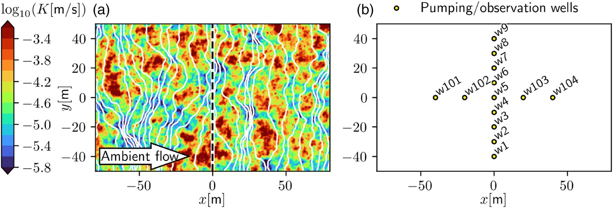
Fig 1. (a) Reference log-hydraulic conductivity field and contour-lines of hydraulic head (white lines) for ambient flow. No-flow conditions are applied at the boundaries at the top and bottom. The central dashed line indicates the defined control plane. Buffer zones (15 km) are applied up- and downstream of the domain shown. (b) Location of wells.
We're pleased to highlight this publication by Konstantin Drach, Carsten Leven, and Olaf A. Cirpka, which introduces a novel Discharge-Targeted Hydraulic Tomography (DTHT) approach for quantifying and locating groundwater discharge in heterogeneous aquifers. Using HydroGeoSphere (HGS), the researchers demonstrated how strategically placed pumping and observation wells can provide more accurate estimates of groundwater discharge and identify preferential flow zones than conventional pumping test analyses.
Accurately quantifying groundwater discharge remains a significant challenge in hydrogeology because it depends on both the hydraulic conductivity distribution and hydraulic gradients within highly heterogeneous aquifers. Traditional pumping tests typically estimate a single effective transmissivity using analytical solutions that assume homogeneous aquifer conditions. While these methods can provide reasonable large-scale estimates, they often fail to capture the complex spatial variability of groundwater flow, particularly in aquifers containing preferential flow paths or structural heterogeneity. Although full hydraulic tomography can resolve these complexities, it generally requires dense well networks and extensive field campaigns that are often impractical at larger scales. This study addresses these limitations by developing a simplified, target-oriented hydraulic tomography approach designed specifically to estimate groundwater discharge over management-relevant scales.
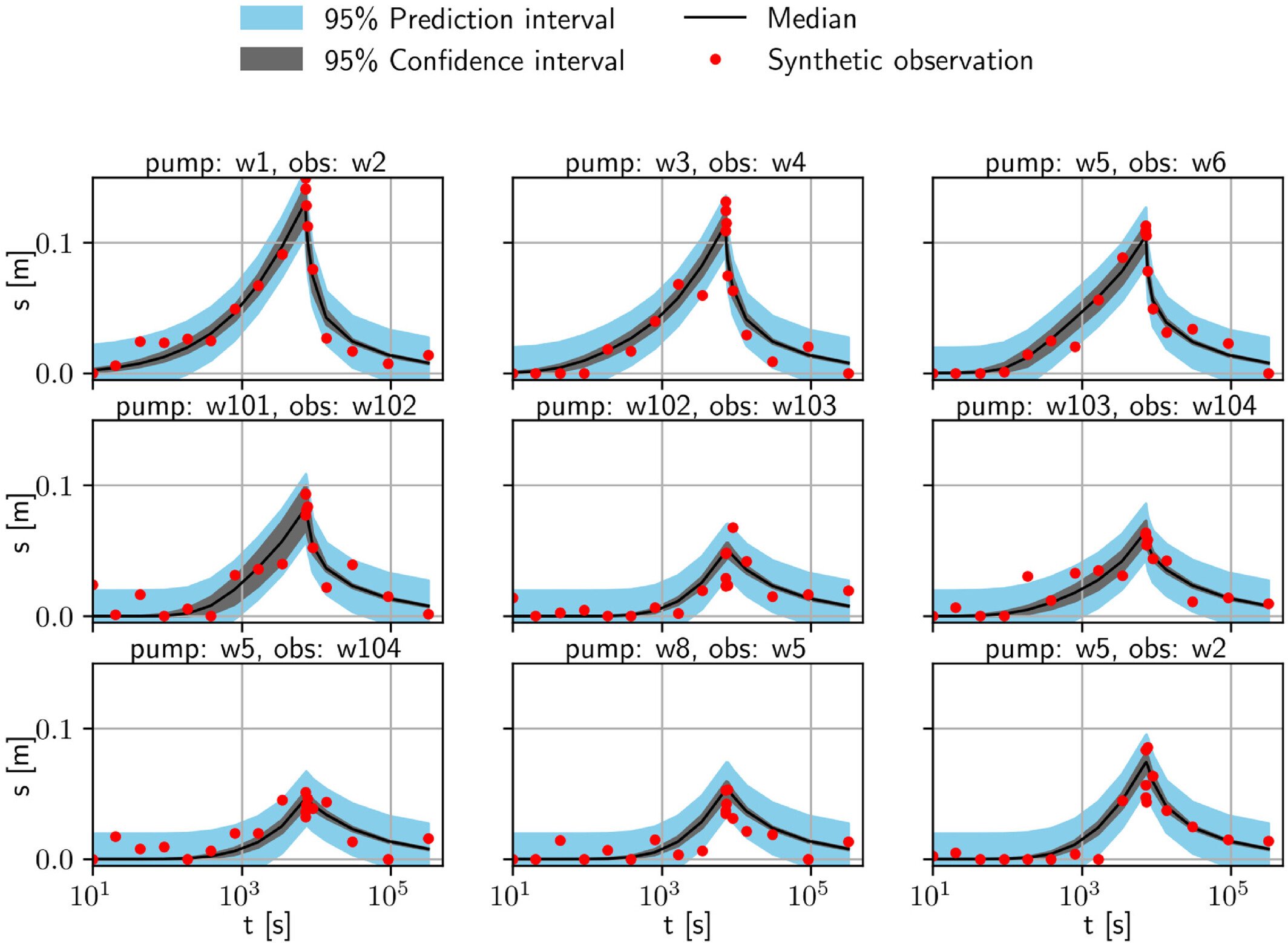
Fig 3. Drawdown over time after start of pumping of the posterior ensemble (gray band and black line) compared to synthetic reference data (red dots). Blue bands indicate the prediction interval. An exemplary selection of pumping (pump) and observation (obs) locations is shown here. The w-numbers indicate the well positions in Figure 1b.
The researchers developed a synthetic channel-like aquifer representing a shallow alluvial valley and simulated groundwater flow using HydroGeoSphere. A series of strategically distributed pumping and observation wells were placed across a 100-metre-wide control plane, where multiple pumping tests were performed and hydraulic head responses were recorded. The resulting drawdown data were combined with ambient groundwater head measurements and analyzed using an iterative ensemble smoother to estimate the spatial distribution of hydraulic conductivity and quantify both total groundwater discharge and localized specific discharge across the aquifer. This approach deliberately sacrificed fine-scale resolution in favour of accurately resolving the flow features that most strongly influence groundwater discharge.
The simulations demonstrated that the discharge-targeted hydraulic tomography approach significantly outperformed conventional pumping test analysis. The method successfully identified the major high- and low-conductivity features controlling groundwater flow while accurately reproducing spatial patterns of specific discharge across the control plane. Compared with traditional analytical interpretations, the tomographic approach produced more accurate estimates of total groundwater discharge, reduced prediction uncertainty, and successfully identified preferential flow zones that would otherwise remain unresolved. The study also showed that even with relatively coarse well spacing, the approach was able to capture the larger-scale flow structures most relevant for groundwater management and contaminant transport investigations.
HydroGeoSphere was central to this research by providing the fully integrated numerical framework needed to simulate both transient pumping tests and ambient groundwater flow within heterogeneous aquifers. The model solved the groundwater flow equations under varying pumping conditions while representing complex hydraulic conductivity distributions, allowing the researchers to evaluate thousands of conductivity realizations during the inversion process. This enabled the team to quantify not only groundwater discharge but also the uncertainty associated with the estimated conductivity fields and flow patterns.
This research demonstrates how HydroGeoSphere can support more efficient groundwater characterization by combining integrated groundwater modelling with advanced inversion techniques. Rather than attempting to resolve every small-scale geological feature, the proposed discharge-targeted approach focuses on identifying the hydraulic structures that most strongly influence groundwater discharge. This provides water resource managers and environmental consultants with a practical method for locating preferential flow paths, improving contaminant remediation strategies, designing hydraulic barriers, and better quantifying groundwater resources while reducing the cost and complexity of traditional hydraulic tomography surveys.
Abstract:
Quantifying and localizing groundwater discharge is inherently difficult. It requires knowledge about hydraulic conductivity and the hydraulic gradient on the scale of interest. Conventional hydraulic testing, such as pumping tests, may fail in the presence of heterogeneity and complex structural boundaries. While advanced 2D and 3D hydraulic tomography may resolve small-scale heterogeneity, it is typically limited to small spatial scales and requires costly field installations. We propose a simplified tomographic approach using a limited number of pumping and observation wells spatially distributed over a well profile in the order of 100 m transverse to the direction of ambient flow. To infer the spatially variable hydraulic-conductivity field from drawdown data with its uncertainty, we apply an iterative ensemble smoother. Subsequently, the posterior ensemble of hydraulic-conductivity fields is used to calculate total and specific discharge based on the observed ambient hydraulic heads in the same wells. We test our approach in a synthetic scenario mimicking a channel-like aquifer such as the quaternary fill in a small river valley. The results demonstrate that multiple spatially distributed pumping tests are suitable to quantify total discharge and its associated uncertainty. The approach is more reliable than a conventional one that estimates effective transmissivity from fitting analytical solutions to pumping-test data. The tomographic analysis additionally allows locating spatial patterns of specific discharge at a resolution similar to the spacing of the wells, which may be important when assessing and remediating contaminant plumes.