

HGS RESEARCH HIGHLIGHT – Three‐Dimensional Geostatistical Inverse Analyses of Transient Head and Temperature Data From a Long‐Term Heat Tracer Test
We’re pleased to highlight this staff research highlighted which investigates how three-dimensional geostatistical inverse modelling can improve characterization of subsurface heterogeneity in groundwater systems. This study leverages HydroGeoSphere (HGS) to simulate fully coupled groundwater flow and transport processes within a stochastic inversion framework, addressing long-standing challenges in estimating spatially distributed hydraulic conductivity fields from limited observational data.
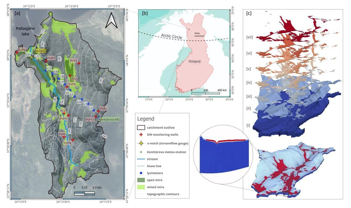
HGS RESEARCH HIGHLIGHT – Stable Water Isotopes Improve Calibration and Flow path Identification in Integrated Hydrological Model
This publication co-authored by Omar Ashraf Nimr, Hannu Marttila, Anna Autio, and Pertti Ala-Aho, investigates how stable water isotopes can improve calibration, uncertainty reduction, and flow path identification in fully integrated surface–subsurface hydrological models. This study leverages HydroGeoSphere (HGS) to explicitly simulate both hydrologic processes and isotope transport, addressing long-standing challenges related to equifinality and internal process realism in groundwater–surface water modelling.
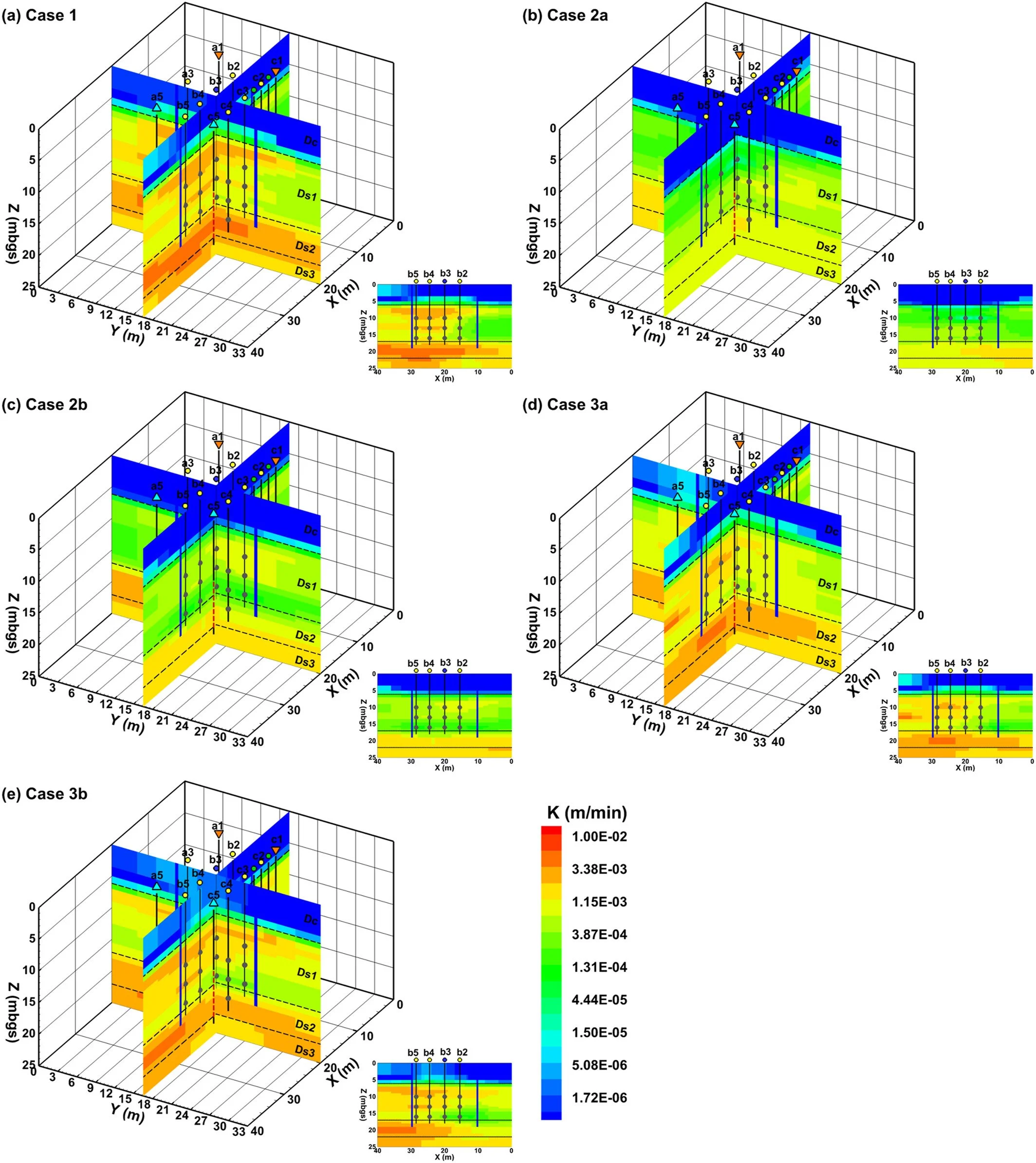
HGS RESEARCH HIGHLIGHT – Characterizing Spatial Heterogeneity of Hydraulic Conductivity Using Borehole NMR in a Complex Groundwater Flow System
This research highlight co-authored by Chenxi Wang, Colby M. Steelman, and Walter A. Illman, investigates how borehole nuclear magnetic resonance (NMR) logging can be used to characterize subsurface heterogeneity and improve the representation of hydraulic conductivity in groundwater flow models. This study leverages HydroGeoSphere (HGS) to evaluate the predictive performance of NMR-derived hydraulic conductivity (K) models and assess how different spatial interpolation and upscaling approaches influence flow and drawdown predictions in a highly heterogeneous aquifer system.

Staff Research Highlight - Steady-state density-driven flow and transport: Pseudo-transient parameter continuation
Co-authored by Aquanty’s senior scientist, Hyoun-Tae Hwang, this research presents a new numerical approach for efficiently solving steady-state density-driven flow and transport equations— an important challenge in groundwater modelling, particularly for coastal aquifers affected by seawater intrusion. The research introduces a hybrid technique called pseudo-transient parameter continuation (PTPC), which combines the robustness of pseudo-transient continuation (PTC) methods with the computational efficiency of parameter continuation (PC) strategies.
Staff Research Highlight - Application of Different Weighting Schemes and Stochastic Simulations to Parameterization Processes Considering Observation Error
In this paper co-authored by Aquanty personnel, researchers explore how different weighting schemes and stochastic simulations can enhance the accuracy of parameter estimation processes, ultimately reducing uncertainty in climate change impact assessments.

HGS RESEARCH HIGHLIGHT – Analyzing variation of the water table level with three-dimensional numerical simulations to assess reclamation techniques for an acidic tailings impoundment
As an extension of the last HGS research highlight titled ‘Improving control of contamination from waste rock piles’, this next research highlight within this series looks at a study conducted by the same researchers and explores the effects of thin cover deposition on managing water table levels in acidic tailings impoundments, while utilizing HydroGeoSphere (HGS) for in-depth simulations.
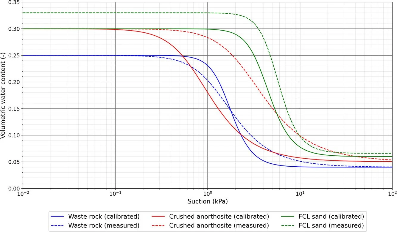
HGS RESEARCH HIGHLIGHT – A black-box automated approach to calibrate numerical simulations and optimize cover design: Application to a flow control layer constructed on an experimental waste rock pile
In this study, researchers developed and tested a novel black-box automated approach to calibrate numerical simulations and optimize cover designs for waste rock piles at mining sites. This work was undertaken by a team of scientists focusing on improving waste rock pile stability and minimizing environmental contamination.
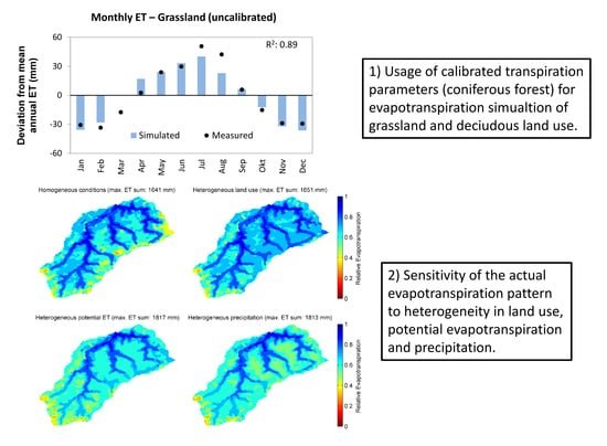
HGS RESEARCH HIGHLIGHT – Using High-Resolution Data to Test Parameter Sensitivity of the Distributed Hydrological Model HydroGeoSphere
By integrating HydroGeoSphere in this study, the researchers demonstrate its versatility in accommodating high-resolution data and conducting sensitivity analyses across different spatial scales. Precipitation emerges as the most sensitive input data, significantly influencing total runoff and peak flow rates. Additionally, the study highlights the importance of spatially distributed land use parameterization in accurately simulating evapotranspiration components and patterns.

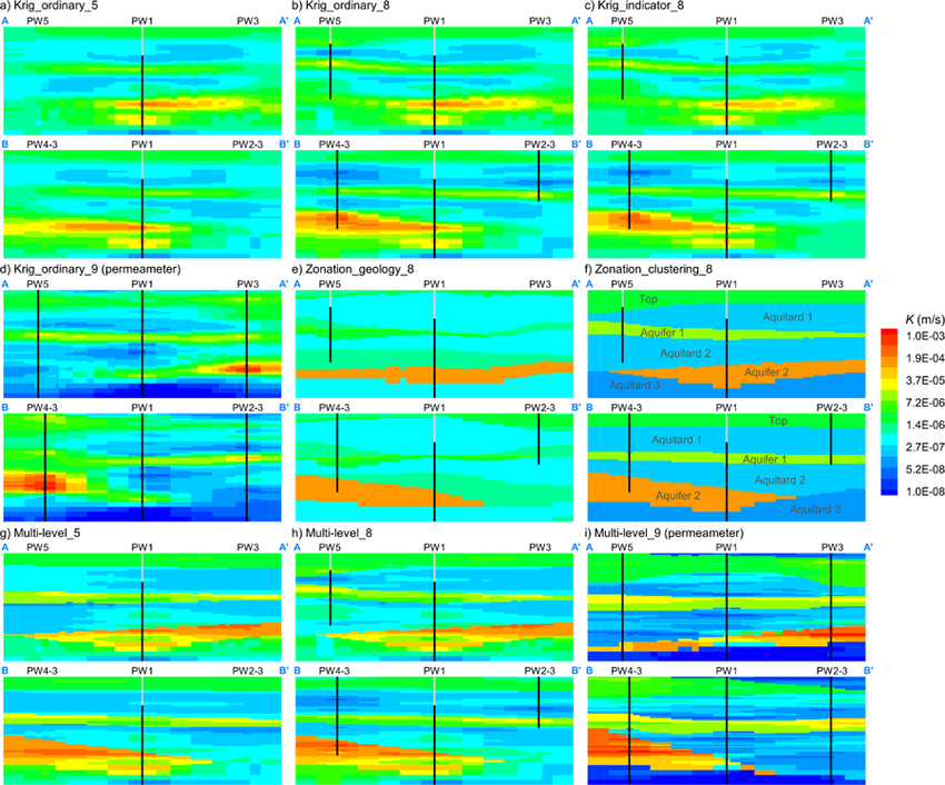
HGS RESEARCH HIGHLIGHT – Evaluation of Hydraulic Conductivity Estimates from Various Approaches with Groundwater Flow Models
Over several decades a wide variety of techniques have been used to estimate the hydraulic flow properties of the subsurface. Here the authors have produced heterogeneous hydraulic conductivity (K) distributions at a heavily instrumented research site using 6 distinct techniques (slight variations in some tests resulted in 9 distinct K distributions):.