
HGS RESEARCH HIGHLIGHT – Quantifying the effects of water management decisions on streambank stability

Wei, Q., Brookfield, A., & Layzell, A. (2024). Quantifying the effects of water management decisions on streambank stability. Frontiers in Water, 6. https://doi.org/10.3389/frwa.2024.1430374
“A streambank stability module was developed in Python to work with output from the integrated hydrologic model, HydroGeoSphere (HGS), which was previously coupled with the surface water operations model, OASIS. The module takes the data output from the coupled HGS/OASIS model, such as surface and subsurface hydrologic conditions (e.g., pore water pressure, groundwater levels), and estimates streambank stability using the simplified factor of safety (Fs) approach, through one-way feedback from HGS/OASIS to the module.”
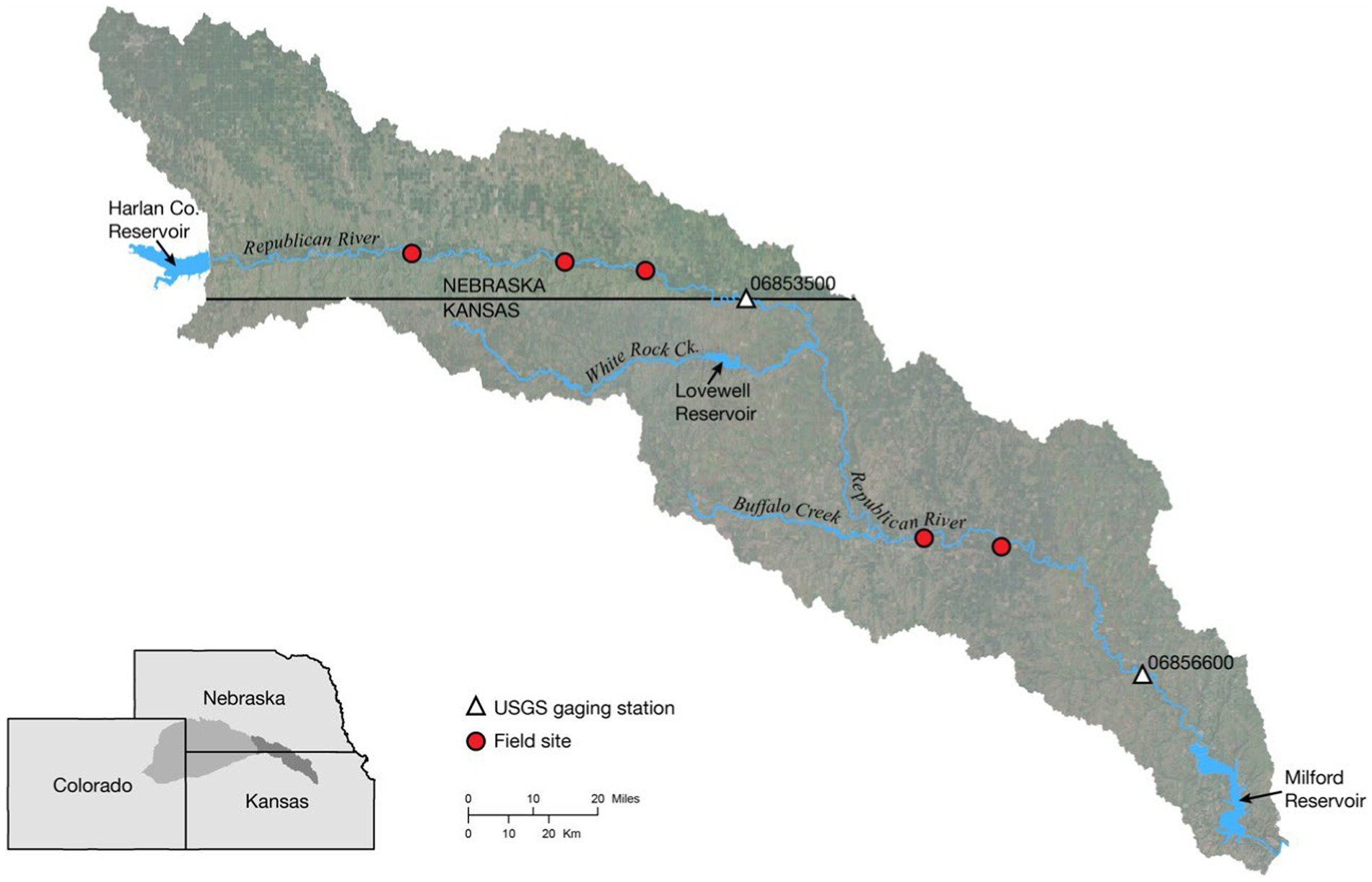
Fig. 5. Map of Lower Republican River Basin study area.
This publication co-authored by Q. Wei, A. Brookfield, and A. Layzell, investigates how water management decisions influence streambank stability by altering subsurface hydrologic conditions. This study leverages HydroGeoSphere (HGS), coupled with the surface water operations model OASIS, to address long-standing challenges in linking reservoir operations, groundwater pumping, and hydrologic dynamics to the physical mechanisms driving streambank failure.
Traditional assessments of streambank stability often focus on hydraulic shear stress or empirical erosion relationships, while treating hydrologic conditions as static or externally prescribed. Such approaches fail to capture how changes in groundwater levels, pore water pressure, and surface–subsurface pressure differentials—often driven by water management decisions—affect bank stability. By using HGS to simulate fully integrated surface and subsurface flow, this research directly links hydrologic state variables to a newly developed streambank stability module based on a factor-of-safety framework.
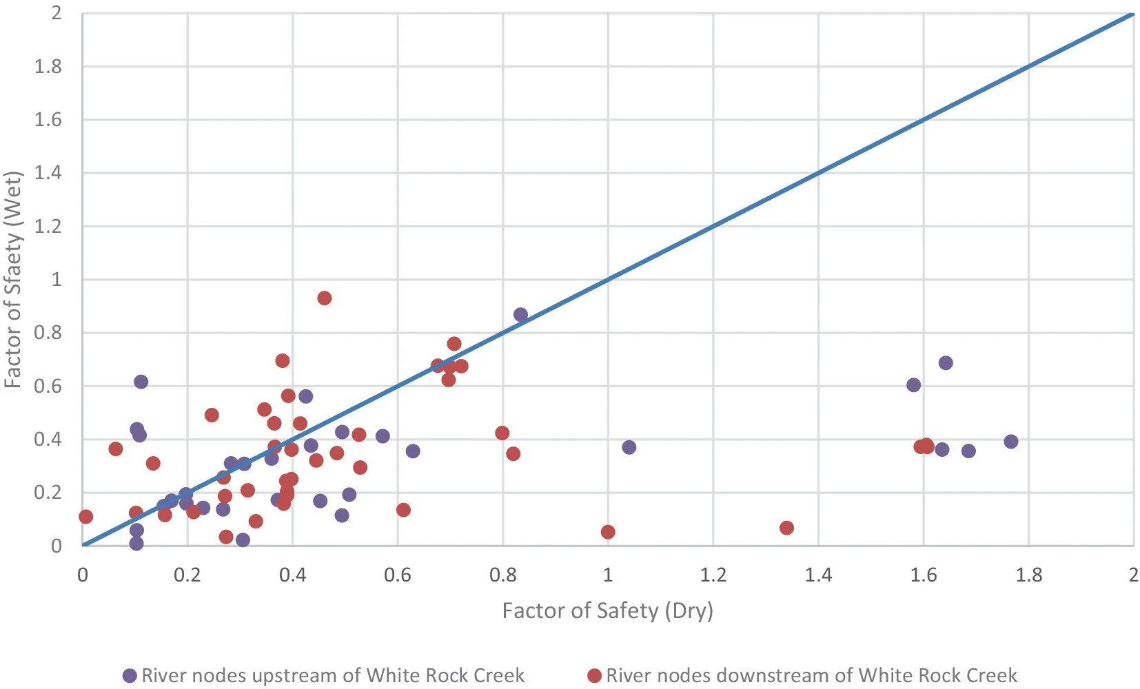
Fig. 8. Relationship between the factor of safety values under wet (high precipitation and elevated groundwater levels) and dry (low precipitation and reduced groundwater levels) conditions.
The study applied this coupled modelling approach to the Lower Republican River Basin in Kansas, United States, under contrasting wet and dry conditions influenced by reservoir operations. Hydrologic outputs from HGS, including groundwater levels, pore water pressure, and surface water depths, were used to calculate spatially distributed streambank stability along more than 700 river nodes. Results showed that streambanks were consistently less stable under wet conditions than dry conditions, particularly in reaches affected by reservoir releases, due to increased pore water pressures and soil loading.
Key findings demonstrated that water management decisions—such as the timing and magnitude of reservoir releases—can significantly alter streambank stability by changing subsurface pressure regimes and disrupting equilibrium between surface water and groundwater levels. In upstream areas with limited releases during dry periods, streambanks were more stable, while downstream reaches receiving managed flows exhibited increased instability even under similar climatic conditions.
HydroGeoSphere proved essential in enabling this work due to its ability to simulate coupled surface and subsurface hydrologic processes and dynamically represent the effects of water management infrastructure. By providing physically consistent hydrologic inputs to the streambank stability module, HGS allowed the researchers to move beyond simplified erosion metrics and directly assess the mechanisms driving bank failure.
This research provides critical insights for integrated water resources management, demonstrating that advanced, physics-based modelling approaches like HydroGeoSphere are essential for evaluating the unintended geomorphic consequences of water management decisions. By explicitly linking reservoir operations and groundwater dynamics to streambank stability, the study paves the way for more informed and sustainable river basin management strategies.
Abstract:
Both natural processes and human activities alter streamflow conditions, which can significantly affect streambank erosion and stability, leading to consequences such as sedimentation of reservoirs, contamination of streams, loss of productive land, and damage to infrastructure. Hydrological conditions, which are often controlled by water management decisions and infrastructure (e.g., reservoirs and dams), are a major factor affecting streambank erosion and stability. Extensive research has explored the relationships between hydrology, water management, and streambank stability. However, limited studies directly address the impacts of water management decisions, particularly reservoir operations, on the driving mechanisms of streambank stability such as changes in pore water pressure, pressure differentials between the surface and subsurface, and gravitational forces versus shear stress. This study builds upon these existing concepts by integrating them into a model that accounts for both the effects of water management and inherent hydrologic conditions on streambank stability.
The module estimates streambank stability using a factor of safety approach, with hydrologic conditions derived from an established integrated hydrologic model, HydroGeoSphere, coupled with the surface water operations model, OASIS. This module is validated and then demonstrated using simulations from the Lower Republican River Basin in Kansas, United States. Results indicate that several water management decisions, such as groundwater pumping and timing of reservoir releases, may negatively affect streambank stability by changing pore water pressure, the weight of the bank material, and the pressure differential between the surface and the subsurface. Given that most of the rivers and streams of the world are regulated by reservoir operations, this work demonstrates that water management practices need to be considered in simulations of streambank stability.