
HGS RESEARCH HIGHLIGHT – Three‐Dimensional Analysis of Heat Tracer Transport With High‐Resolution Subsurface Heterogeneity Characterization in a Complex Aquifer System

Wang, C., Ning, Z., Luo, N., Zhao, Z., Berg, S. J., Hwang, H., & Illman, W. A. (2026). Three‐Dimensional Analysis of Heat Tracer Transport With High‐Resolution Subsurface Heterogeneity Characterization in a Complex Aquifer System. Water Resources Research, 62(6). https://doi.org/10.1029/2025wr042412
“The groundwater flow and heat transport simulations were conducted using HydroGeoSphere (Aquanty Inc, 2025). To minimize the impacts of boundary conditions, the simulation domain was assigned dimensions of 70 × 70 × 17 m with PW1 located in the center (refer to Figure 1a).”
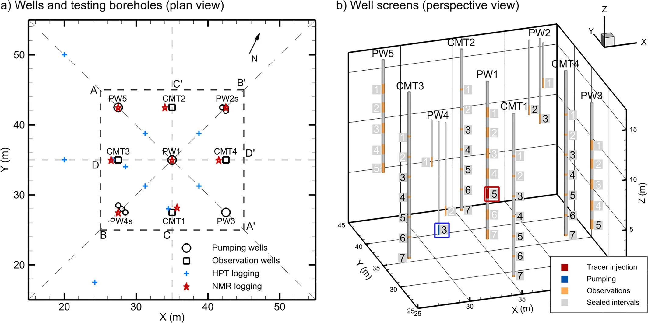
Fig 1. Locations of monitoring wells and testing boreholes. (a) Plan view of the locations of the monitoring wells, hydraulic profiling tool logging, and nuclear magnetic resonance logging. The dashed-line square (A-B’–A’-B) delineates the area of the data domain (20 m × 20 m) for subsequent visualization of K and porosity distributions, which encompasses the wells (within a 15 m × 15 m extent). The coordinates are consistent with the simulation domain of the numerical model of heat transport. (b) Perspective view of the well screens, in which the screens for heat tracer injection, pumping, observation, and sealed intervals are highlighted in different colors. Screens numbered in black were used for observation of temperature changes during the tracer test. Tracer injection well (PW1-5) and pumping well (PW4-3) are highlighted with red and blue squares, respectively.
We're pleased to highlight this publication by Chenxi Wang and colleagues, co-authored by Aquanty's Steven Berg and Hyoun-Tae Hwang, which investigates how high-resolution characterization of subsurface heterogeneity can improve predictions of heat tracer transport in complex aquifer systems. The study leverages HydroGeoSphere (HGS) to simulate three-dimensional groundwater flow and heat transport, evaluating how different methods of representing hydraulic conductivity influence the ability to reproduce observed tracer behaviour in highly heterogeneous glaciofluvial deposits.
Accurately predicting groundwater flow and tracer transport in heterogeneous aquifers remains one of the greatest challenges in hydrogeology. Traditional approaches often rely on interpolated borehole measurements or simplified zonal representations of hydraulic conductivity, which can reproduce general hydraulic behaviour but frequently fail to capture the preferential flow paths that control tracer migration. This research addresses these limitations by comparing several characterization techniques—including permeameter testing, hydraulic profiling tool (HPT) logging, and hydraulic tomography (HT)—to determine which best represents the complex subsurface conditions governing heat transport.
The study applied HydroGeoSphere to simulate a forced-gradient heat tracer experiment conducted at the University of Waterloo's North Campus Research Site. Chilled groundwater was injected into a highly heterogeneous glaciofluvial aquifer while temperatures were monitored at multiple depths and locations throughout the subsurface. Seven different hydraulic conductivity models were then used within HGS to simulate the three-dimensional evolution of the heat plume. Results showed that models based on hydraulic tomography reproduced the observed temperature breakthrough curves and plume migration far more accurately than kriged or zonal conductivity representations, despite requiring no calibration to the transport data.
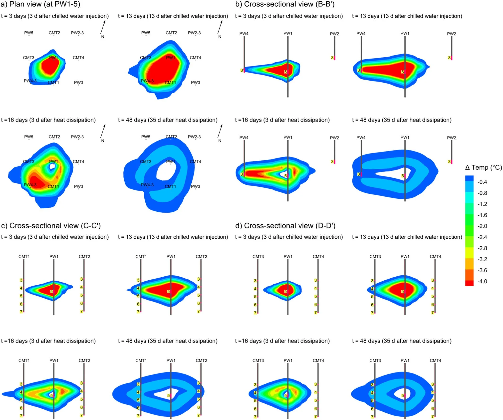
Fig 8. The simulated spatiotemporal evolution of heat tracer plumes in the plan view crossing PW1-5 and PW4-3, and three cross-sectional views of B-B’, C-C’, and D-D’. The temporal evolution of the heat tracer plume at four time points is simulated, including 3 and 13 days after chilled water injection, and 3 and 35 days after heat tracer dissipation. This heat transport simulation used the K field of model HT_8.
Key findings demonstrated that hydraulic conductivity heterogeneity is the dominant factor controlling heat tracer transport in complex aquifer systems. While variations in porosity, thermal conductivity, and mechanical dispersion influenced simulation results, accurately resolving the spatial distribution of hydraulic conductivity proved far more important for predicting preferential flow pathways and the timing of heat transport. The study also showed that hydraulic tomography can reliably characterize these heterogeneities, providing a strong foundation for predicting three-dimensional tracer movement in the subsurface.
HydroGeoSphere proved essential in enabling this work due to its ability to simulate fully coupled groundwater flow and heat transport while accounting for temperature-dependent changes in water density and viscosity. By integrating detailed hydraulic conductivity fields derived from multiple characterization methods, HGS allowed the researchers to directly evaluate how different representations of subsurface heterogeneity affect heat tracer transport without relying on site-specific calibration to tracer observations.
This research provides critical insights for groundwater characterization, contaminant transport, and shallow geothermal energy applications, demonstrating that advanced modelling approaches like HydroGeoSphere can significantly improve predictions of tracer behaviour in heterogeneous aquifer systems. By combining high-resolution field characterization with fully integrated numerical modelling, the study highlights the importance of accurately representing subsurface heterogeneity to support more reliable groundwater management and geothermal system design.
Abstract:
Accurate predictions of tracer transport in complex aquifer systems remain a formidable challenge, primarily owing to the spatial heterogeneity of hydraulic conductivity (K). Here, we conducted a forced-gradient heat tracer test within a highly heterogeneous glaciofluvial deposit, injecting chilled water and monitoring temperature at depth-specific ports, which revealed highly non-uniform, three-dimensional plume migration. To investigate whether such complex transport behavior can be reproduced with subsurface heterogeneity characterization approaches, we compared transport simulations based on several K representations: kriged and zonal K fields derived from direct-push K logging, permeameter measurements, and pumping test data, as well as hydraulic tomography (HT) results, which utilized the geostatistical inverse modeling of head response data from multiple pumping tests to map K heterogeneity. Furthermore, we employed borehole nuclear magnetic resonance logging to estimate porosity distributions. We examined the impacts of porosity, mechanical heat dispersivity, and thermal conductivity on heat tracer transport. Results showed that K heterogeneity is the key factor governing the highly variable temperature breakthrough curves observed across the monitoring network. Simulations relying on spatial correlation of borehole data were insufficient to capture the three-dimensional thermal patterns, whereas the HT-based simulations reasonably reproduced the spatiotemporal evolution of the tracer plume and delineated the advection-dominant regions, without site-specific calibration to transport data. Our findings demonstrate that HT analysis provides a reliable basis for predicting heat tracer transport behavior in complex aquifer systems.