
“The ability and history of HGS to accurately simulate flow in oil sand sites, and its ability to represent perched groundwater conditions, resulted in selection of this model as the most appropriate distributed hydrologic model for this study.”
Davison, J. H., Hwang, H.-T., Sudicky, E. A., Mallia, D. V., & Lin, J. C. (2026). Hydrological analysis of the California Basin Model. PLOS Water, 5(6), e0000535. https://doi.org/10.1371/journal.pwat.0000535
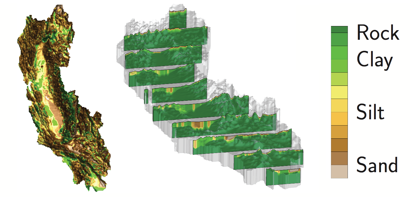
Fig 1. Three-dimensional California geological model with a top view (left) displaying the surface level geology and perspective view (right) showing 10 cross-sectional views.
We’re pleased to highlight this publication by Jason Hamilton Davison, Hyoun-Tae Hwang, Edward A. Sudicky, Derek V. Mallia, and John C. Lin, which presents the development and hydrological analysis of a large-scale, integrated model of the California Basin. The study uses HydroGeoSphere (HGS) and a two-way coupled HydroGeoSphere–Weather Research and Forecasting (HGS-WRF) model to investigate interactions between groundwater, surface water, evapotranspiration, precipitation, and the atmosphere across California’s interconnected water system.
CLICK HERE TO READ THE ARTICLE.
California’s water resources depend on an interconnected network of groundwater, surface water, snowmelt, and interbasin transfers. However, many previous modelling approaches represent individual components or regions of the water cycle separately. To address this challenge, the researchers developed the California Basin Model using HGS to provide an integrated, physics-based representation of surface and variably saturated subsurface flow across the entire 410,000 km² California Basin, encompassing most of California as well as portions of Oregon, Nevada, and northwestern Mexico.
The HGS model incorporates large-scale datasets describing topography, soils, geology, land use, precipitation, potential evapotranspiration, irrigation, and consumptive water use. After establishing pre-development steady-state conditions, groundwater and surface-water extractions were introduced and the model was simulated forward to 2011. The researchers represented water use through nearly 20,000 pumping locations distributed throughout the model domain, allowing the simulation to investigate the long-term influence of groundwater withdrawals and irrigation on California’s hydrologic system.
The researchers then coupled HGS with WRF to simulate interactions between the hydrologic system and atmosphere over a 200-day period from January 1 to July 20, 2011. HGS calculates three-dimensional subsurface flow, two-dimensional overland flow, and process-based evapotranspiration, while exchanging information with WRF. HGS provides actual evapotranspiration and soil saturation to WRF, while WRF returns precipitation and potential evapotranspiration to HGS. This two-way exchange enables groundwater, surface-water, land-surface, and atmospheric processes to influence one another throughout the simulation.
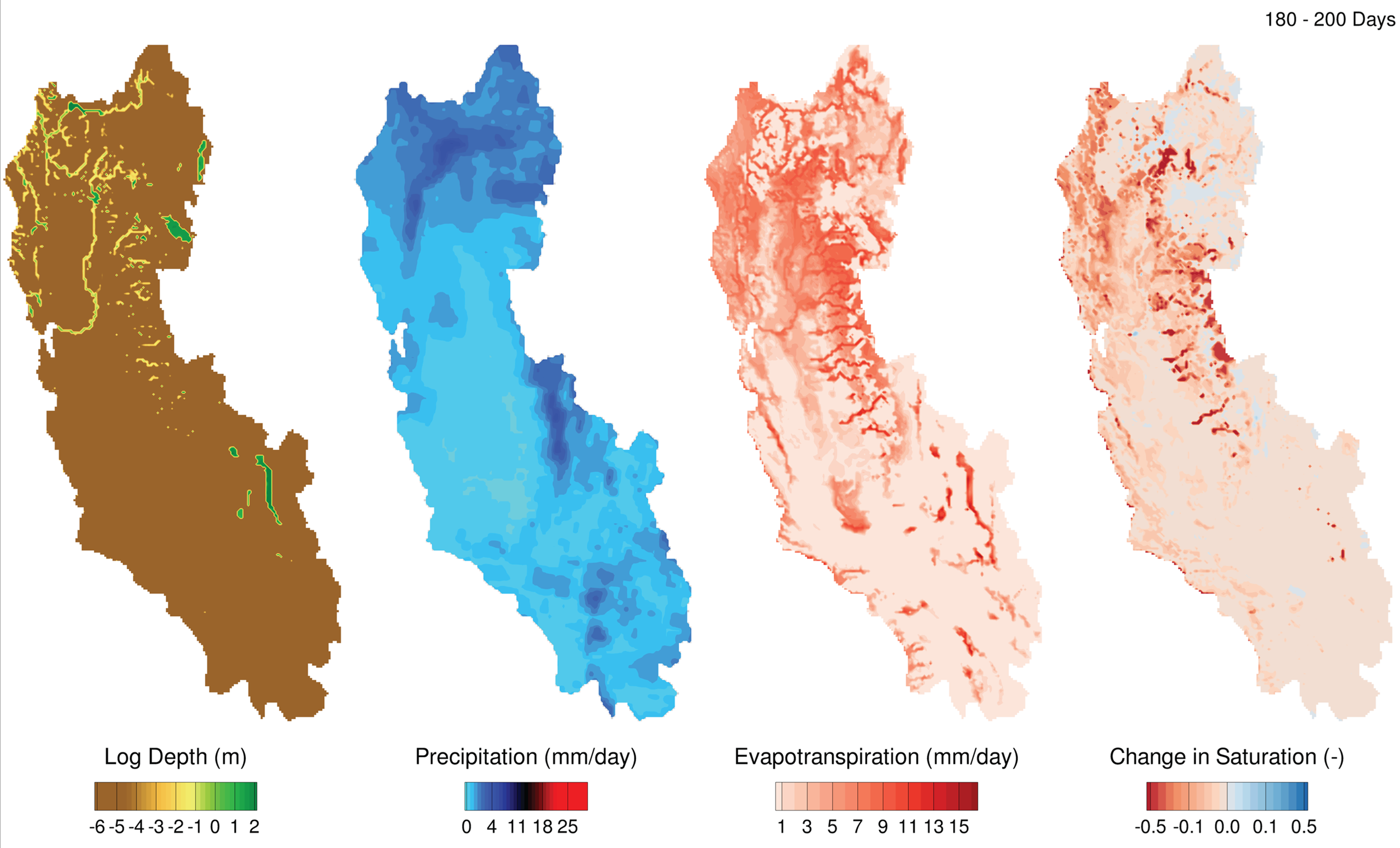
Fig 7. Coupled HGS-WRF simulation displaying surface water log depth (m), precipitation (mm/day), evapotranspiration (mm/day), and change in saturation of the top 10 cm layer (-) for 180 to 200 days (July 1 to July 20).
One of the study’s key findings was a measurable relationship between groundwater depth and evapotranspiration. Across the model domain, simulated evapotranspiration decreased by an average of 0.029 mm/day for every metre of additional water-table depth. The relationship became stronger during the warmer and drier summer months, illustrating how groundwater availability can influence land-surface water and energy exchanges and, in turn, atmospheric processes.
The integrated model also provided insight into the relationship between precipitation, evapotranspiration, groundwater use, and overall water storage. The simulations indicated that, under the pumping conditions represented in the study, the California Basin would require approximately 0.178 m/year of net precipitation—precipitation minus evapotranspiration—to maintain water storage without continued decline. Based on observed precipitation and evapotranspiration rates, the model estimated an annual water-level decline of approximately 49 mm/year, similar to the 43 mm/year decline measured by GRACE satellite observations for the period examined. The authors note that the sustainable-yield estimate is based on the 200-day coupled simulation rather than a full annual or multiyear climatological assessment.
The study also demonstrated the ability of the coupled model to reproduce important aspects of California’s observed hydrology. Comparisons with meteorological observations showed that the simulation generally captured temporal patterns in precipitation and evapotranspiration, although both exhibited a moderate positive bias. Simulated streamflow also reproduced the general hydrograph trends of the Sacramento and Klamath rivers, including the Sacramento River’s major peak-flow response. The researchers identify opportunities for further improvement through model calibration and the inclusion of processes and infrastructure such as snowmelt, dams, and reservoirs.
This research demonstrates how HydroGeoSphere can be applied at basin scale to represent the complete hydrologic system, rather than treating groundwater, surface water, and land–atmosphere exchanges independently. By combining integrated hydrologic modelling with atmospheric simulation, the California Basin Model provides a framework for investigating feedbacks that are difficult to capture with models focused on individual components of the water cycle. The results highlight the importance of considering groundwater alongside surface and atmospheric processes when evaluating water availability, groundwater depletion, evapotranspiration, and the long-term sustainability of water resources in complex, heavily managed systems.
Abstract:
California’s water resources are declining and recent droughts have only exaggerated the dire conditions. As rivers and surface water reserves run dry, water managers are forced to drill deeper wells, mining their precious groundwater resources. To better understand California’s water, we developed a surface and subsurface model of the California Basin using HydroGeoSphere (HGS), a 3D finite element control-volume surface and variably-saturated subsurface flow model with evapotranspiration processes. Once the integrated HGS model reached steady-state conditions, groundwater and surface water extractions were turned on, and the HGS model was run to 2011. We then implemented the two-way coupled HydroGeoSphere-Weather Research and Forecasting (WRF) model over a 200 day period. This paper investigates feedbacks between groundwater and evapotranspiration and finds an average decrease of 0.029 mm/day in evapotranspiration per meter of water table depth over the period January 1st to July 20th 2011. The simulation results showed that a minimum net precipitation rate of 0.178 m/year (R2 = 0.998) is required every year to sustainably maintain current water use and groundwater extractions. The simulated results replicated similar drawdown behavior (49 mm/year simulated) as the GRACE remote sensing satellites (43 mm/year measured).