

Arnoux, M., Cochand, F., Brunner, P., Schaefli, B., Winstral, A., & Hunkeler, D. (2026). Groundwater storage in Quaternary deposits and bedrock buffers the discharge response of a small alpine catchment to climate change. Hydrogeology Journal. https://doi.org/10.1007/s10040-026-03157-5
“The model was trained to predict monthly groundwater discharge (GWD) and radionuclide transport (RNT), and its performance was evaluated against the results from HGS, which serves as a physically rigorous reference model.”
“Because real-world data for the hypothetical ADioS watershed were unavailable, the HGS model, which is a fully distributed, physically based, integrated surface–subsurface hydrological model, was used to simulate groundwater flow and radionuclide transport for target feature extraction.”
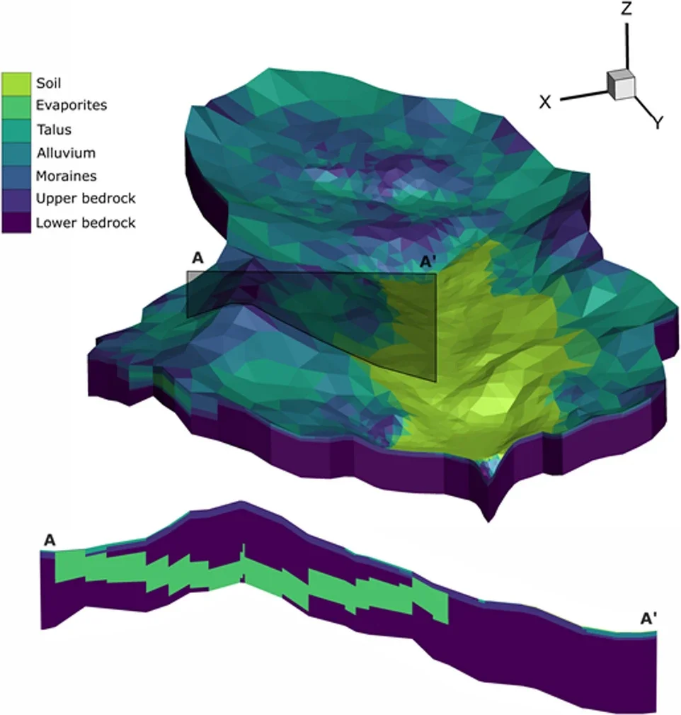
Fig 2. Illustration of the HGS model and geology
We’re pleased to highlight this publication by Marie Arnoux, Fabien Cochand, Philip Brunner, Bettina Schaefli, Adam Winstral, and Daniel Hunkeler, which uses HydroGeoSphere (HGS) to investigate how groundwater storage can buffer the effects of climate change on streamflow in snow-dominated alpine catchments. In particular, the study examines how groundwater stored within different geological formations influences future summer low flows as snow accumulation and melt patterns change.
Alpine regions play an important role in supplying water to downstream valleys, particularly by releasing stored water during warm and dry periods. However, groundwater and the influence of geology are often underrepresented in studies of future alpine water resources. The researchers sought to address this by quantifying groundwater storage dynamics and examining how individual geological units contribute to low-flow generation under current and future climate conditions.
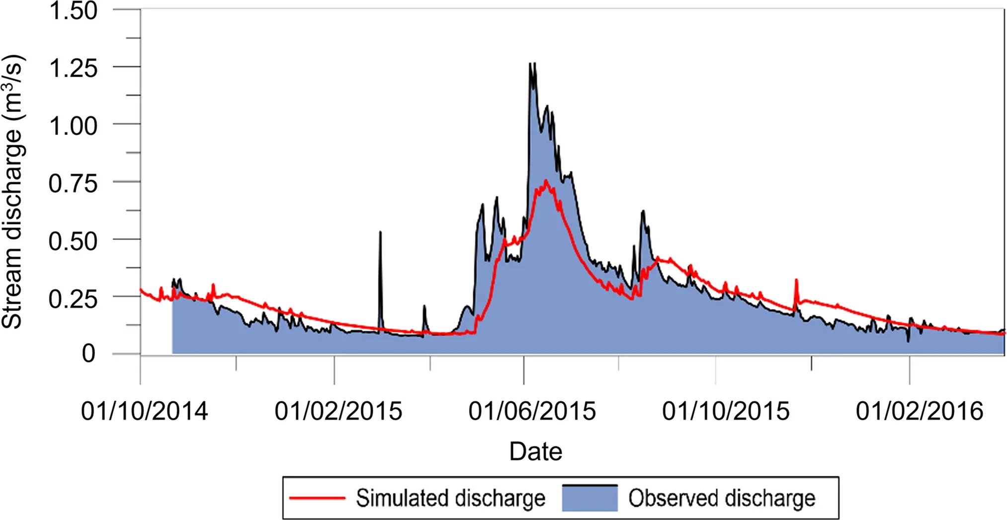
Fig 3. Simulated daily discharge compared to the measured daily streamflow for the period 21.10.2014—01.04.2016
The modelling framework was based on conditions typical of the Vallon de Réchy, an approximately 11 km², non-glacierized alpine catchment in the Swiss Alps. The catchment ranges from 2,150 to 3,148 m above sea level and contains a mixture of bedrock, evaporites, and unconsolidated Quaternary deposits, including alluvium, talus, and moraines. These different geological formations provided the researchers with a basis for investigating where groundwater is stored and how that storage contributes to streamflow.
Using HydroGeoSphere, the researchers developed an integrated surface–subsurface model that simultaneously represents three-dimensional variably saturated subsurface flow, two-dimensional surface flow, infiltration and exfiltration, evapotranspiration, snow accumulation and snowmelt, and catchment discharge. This integrated representation was particularly important because groundwater recharge and exchanges between streams and aquifers are central to understanding how alpine water resources may respond to a changing climate.
The model was evaluated against observed streamflow and groundwater levels, with particular attention paid to reproducing low-flow conditions. For an independent validation period, simulated discharge achieved a Nash–Sutcliffe efficiency of 0.73, while the study notes that low flows were well reproduced. The researchers then drove the model using two RCP8.5 climate projections from 1981 to 2099, selected to investigate relatively strong warming and changes in snowmelt and groundwater recharge. The authors emphasize that these scenarios represent upper-bound climate impacts rather than moderate future conditions.
The simulations showed substantial changes in the catchment's snow regime by the end of the century. Mean snow water equivalent decreased by approximately 100 mm under one climate scenario and 120 mm under the other, while annual snowmelt declined by approximately 150 and 245 mm/year, respectively. At the same time, mean annual evapotranspiration increased by around 45 mm, and mean annual groundwater storage across the catchment decreased by approximately 110–130 mm.
Importantly, the response differed considerably between geological formations. Most of the decline in mean annual groundwater storage occurred within the low-permeability bedrock, where storage decreased by approximately 125 mm by the 2085 period. In contrast, mean annual groundwater storage within the Quaternary deposits remained relatively stable. These deposits, concentrated largely within the valley bottom, can receive recharge from precipitation and snowmelt as well as groundwater from the surrounding bedrock and, depending on the season, from streams.
The seasonal results reveal an important groundwater buffering effect. By 2085, simulated summer discharge declined substantially: August discharge decreased by approximately 38–45%, while September discharge declined by approximately 45–55%, depending on the climate scenario. Yet groundwater storage in the Quaternary deposits declined by only about 10–14% during these months. The researchers found that streams and Quaternary aquifers are closely connected: streams recharge these aquifers during spring, while groundwater stored within them contributes back to streamflow during low-flow periods.
The timing of low flows also changed. Under the simulations, the annual low-flow period gradually shifted from winter toward late summer, ultimately shifting to summer after 2092 in the scenario examined in detail. Future summer low flows generally remained higher than present-day winter low flows, but after exceptionally dry summers they approached similar levels. This suggests that groundwater can help buffer changes in streamflow, although its ability to do so may become limited during prolonged periods of low precipitation.
A sensitivity analysis further demonstrated that the geological composition of the catchment plays an important role in determining this buffering capacity. Moraine and talus deposits primarily regulate groundwater storage and buffering: lower hydraulic conductivity within these units increases storage and supports higher low flows. Bedrock plays a complementary role, with higher bedrock hydraulic conductivity allowing more stored groundwater to be released to streams during dry periods. Overall, the researchers found that both Quaternary deposits and bedrock are important for maintaining discharge during low-flow conditions.
This research demonstrates how HydroGeoSphere can be used to explicitly connect geology, groundwater storage, surface water and climate change within an integrated modelling framework. Rather than considering changes in snowmelt or streamflow alone, the study shows that understanding where groundwater is stored— and how different geological units release that water— is critical for evaluating future water availability in alpine environments. The findings highlight groundwater as an important buffer against declining summer flows, while also demonstrating that this buffering capacity is finite and strongly dependent on the hydrogeological characteristics of the catchment.
Abstract:
Alpine areas play a major role in the water supply of downstream valleys by releasing water during dry periods. Groundwater storage could significantly influence how changing climatic conditions affect the discharge regime. However, these processes are still not well understood in alpine areas. Studies on how climate change impacts water resources in alpine areas rarely consider the influence of geology explicitly. An integrated surface–subsurface hydrologic model (HydroGeoSphere) was used to highlight the effect of groundwater in buffering future summer low flows and to give new insights into the role of geology in controlling discharge. The spatially explicit model allows the quantification of groundwater storage and its variation in different geological formations of an alpine catchment, under current and future conditions. The results suggest that, under future extreme climate change conditions, the average catchment groundwater storage in Quaternary deposits increases in winter and decreases in summer; the annual mean groundwater storage for the entire catchment decreases due to the decrease in mean annual groundwater recharge; and the total catchment discharge decreases and low-flow period shifts from winter to late summer by the end of this century. Future summer low flows will remain higher than the current winter low flows but will approach them closely after very dry summers. Proportionally, the decrease in groundwater storage will be less severe than the decrease in discharge. Finally, a sensitivity analysis illustrates that both Quaternary deposits (especially moraine and talus units) and bedrock play an important role in supporting discharge during low-flow periods.