
Staff Research Highlight - Water Balance and Flow Tracer Application Using a Fully Integrated Hydrologic Model in a Pilot-scale Oil Sands Pit Lake Catchment
“The ability and history of HGS to accurately simulate flow in oil sand sites, and its ability to represent perched groundwater conditions, resulted in selection of this model as the most appropriate distributed hydrologic model for this study.”
Tafvizi, A., Ehrman, J., Sharifinejad, A., Zhang, D., Callaghan, M., Berg, S., Miller, K., Wang, M., & Fan, X. (2026). Water Balance and Flow Tracer Application Using a Fully Integrated Hydrologic Model in a Pilot-scale Oil Sands Pit Lake Catchment. Mine Water and the Environment. https://doi.org/10.1007/s10230-026-01135-7
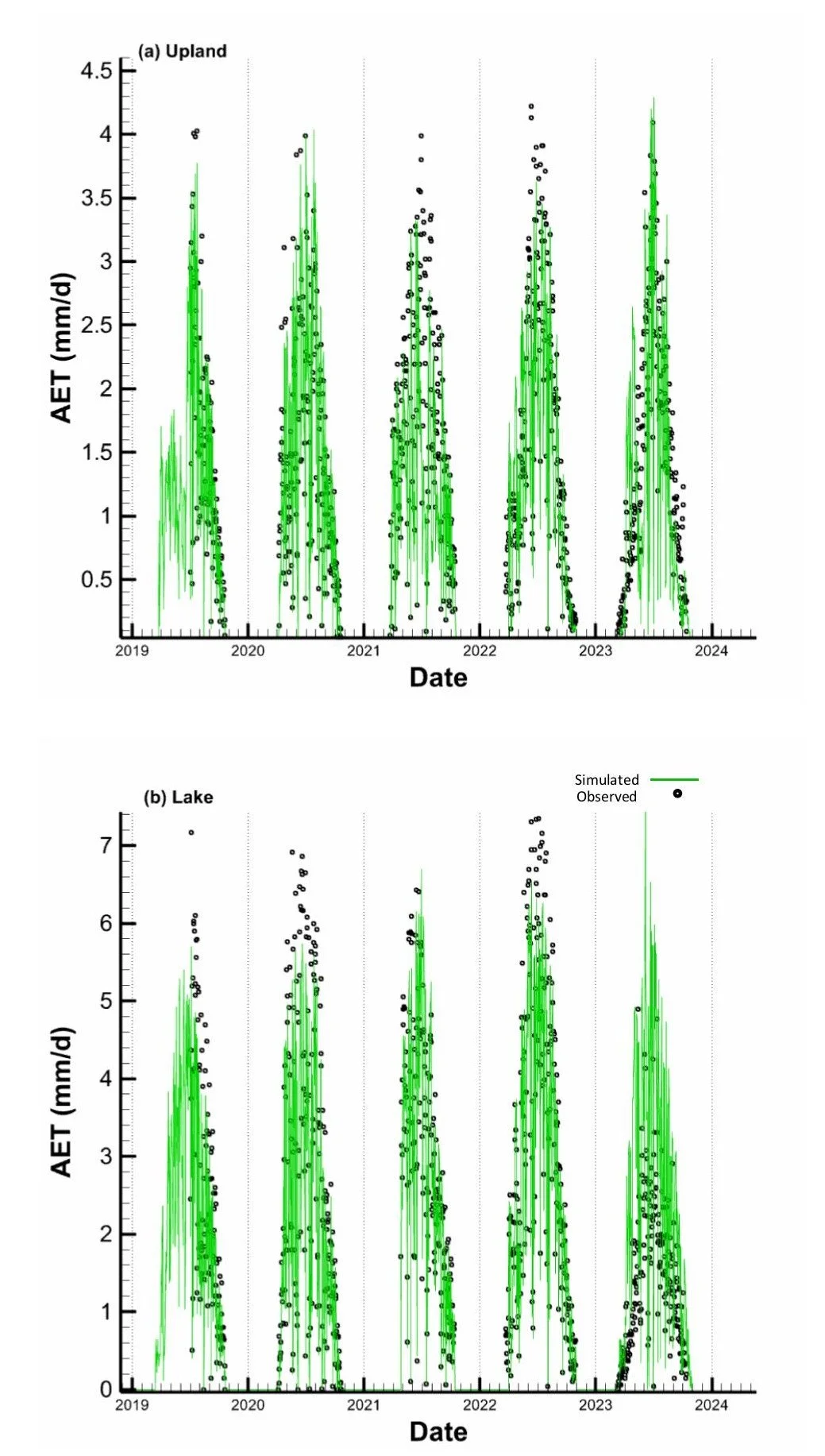
Fig 7. Observed vs. simulated AET in (a) upland flux tower and (b) lake flux tower
We're pleased to highlight this new publication by Aquanty staff, including Arghavan Tafvizi, James Ehrman, Ali Sharifinejad, Diana Zhang, Michael Callaghan, Steven Berg and Killian Miller, along with our collaborators at Suncor Energy Mike Wang, and Xiaoying Fan. This paper demonstrates the use of HydroGeoSphere (HGS) and the Hydraulic Mixing Cell (HMC) method to better understand water movement within a constructed end pit lake watershed. Using the Lake Miwasin Watershed in northern Alberta as a pilot-scale study site, the researchers developed and calibrated an integrated hydrologic model to simulate surface water, groundwater, lake levels, and evapotranspiration, while using HMC to identify how different areas of the watershed contribute to lake inflow under changing seasonal and climatic conditions.
CLICK HERE TO READ THE ARTICLE.
Pit lakes are increasingly incorporated into mine closure and reclamation plans across Canada's Athabasca Oil Sands region. Because these constructed water bodies exist within reclaimed landscapes, understanding how water moves through their surrounding watersheds is critical for evaluating their long-term hydrologic function and informing effective reclamation design. Directly measuring groundwater contributions and tracing water pathways in the field can be difficult, particularly where surface water and groundwater are closely connected. This study addresses that challenge by applying a fully integrated modelling approach capable of representing these interactions while tracking where water entering the lake originates within the watershed.
“Calibration target weights were selected to ensure that the composite initial error value within each target group (lake water level, lake inlet flow, shallow groundwater level, and deep groundwater level) were approximately of equal magnitude, except for the AET target group. In the case of AET, the weights were allocated such that the AET (both upland and lake) target group exhibited an original error one order of magnitude higher. This deliberate adjustment stems from the recognition that AET is the dominant mechanism of water loss in the western boreal landscape. Furthermore, changes in the balance of AET and precipitation can cause large changes to the hydrologic regime of the system, which all other components of the PEST objective function are determined by. Hence, AET was prioritized as an especially impactful calibration target.”
The researchers developed a HydroGeoSphere model of the approximately 9-hectare Lake Miwasin Watershed, an engineered pilot-scale watershed located approximately 15 km north of Fort McMurray. The watershed includes constructed hummocks, swales, flat vegetated areas, opportunistic wetlands, and a end pit lake, along with a perched near-surface water table separated from the deeper regional groundwater system. The model represented key hydrologic processes including surface water–groundwater interactions, unsaturated-zone storage and release, evapotranspiration, and seasonal freeze–thaw dynamics. The watershed was divided into hydrologic response units (HRUs) based on characteristics such as topography, vegetation, water transmission, storage, runoff behaviour, and evapotranspiration.
The HGS model was calibrated using PEST_HP against observed shallow and deep groundwater levels, actual evapotranspiration, Lake Miwasin inlet flow, and lake water levels. The calibrated model generally reproduced the observed hydrologic behaviour of the watershed, including groundwater levels and lake conditions, and successfully represented the upland's role in generating runoff and delivering water toward the lake. The model also reproduced groundwater mounding beneath the hummocks and the movement of shallow groundwater downslope toward the swales, where water can continue toward Lake Miwasin as either shallow groundwater or surface water.
The researchers then applied the Hydraulic Mixing Cell method in HGS to track water originating from different portions of the watershed and determine their contributions to the Lake Miwasin inlet hydrograph. HMC tags water associated with user-defined areas or sources and tracks its movement through the model using the hydraulic flow solution. This provides a way to distinguish flow-generation mechanisms and quantify where water originates without relying on conventional solute transport simulations. Because HMC derives its results directly from the HGS flow solution, it can also provide a more computationally efficient approach for investigating water sources and pathways when dispersion modelling is not required.
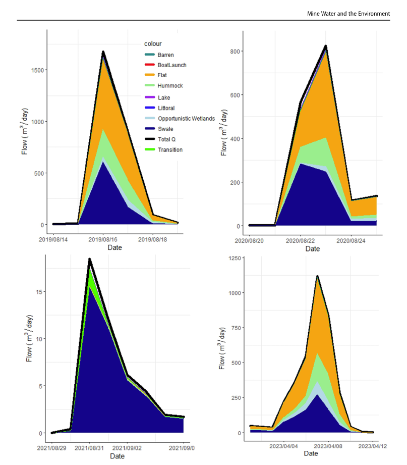
Fig 12. Examples of hydrograph separated according to water contributed from different HRUs
The HMC analysis revealed clear differences in how individual areas of the watershed contribute to lake inflow. The Flat HRU was the dominant annual contributor, accounting for more than 41% of Lake Miwasin inlet flow, although contributions varied with climatic and hydrologic conditions. Between 2020 and 2022, the Flat HRU provided the largest contribution, while the Swale HRU became the largest contributor in 2023. Opportunistic wetlands also contributed a relatively large proportion of flow despite their comparatively small size and disconnected distribution across the watershed.
Seasonal analysis further demonstrated how watershed flow pathways change throughout the year. During spring freshet, frozen or saturated ground limited infiltration and resulted in overland flow of snowmelt, increasing contributions from the Flat and Hummock HRUs. In dry conditions lower soil saturation increased infiltration rates and reduced overland flow, resulting in a greater proportion of lake inflow originating from the Swale HRU. The analysis also captured differences between wetter and drier years, demonstrating how HMC can provide insight into changes in watershed function and flow pathways across interannual climate conditions.
This research demonstrates how HydroGeoSphere and the Hydraulic Mixing Cell method can be used together to move beyond conventional water balance modelling and investigate where water originates, how it moves through a watershed, and how those pathways change over time. Importantly, this study represents the first application of HMC to a real-world engineered watershed. By identifying the areas and hydrologic processes that contribute most strongly to end pit lake inflows under different conditions, the approach can provide valuable information for mine closure design, water management, and reclamation planning across oil sands mine sites.
Abstract:
Pit lakes are increasingly proposed in mine closure plans across Canada's Athabasca Oil Sand sites. An accurate understanding of water movement, above and below ground, is crucial for effective closure landform design and tailings management. This study integrates the hydraulic mixing cell (HMC) method into the HydroGeoSphere (HGS) model to precisely track water movement within modeled catchments and estimate source water contributions from distinct watershed parts to better understand surface and groundwater movement. The Lake Miwasin Watershed is a pilot-scale pit lake catchment in the Canadian Boreal shield, constructed and operated by Suncor Energy Inc. A HGS model of the Lake Miwasin catchment was constructed by Aquanty Inc. for Suncor Energy Inc. The HGS model calibration and validation targeted surface water flow, lake level, deep and shallow groundwater levels, and actual evapotranspiration (AET). Using the HMC method, the water contribution for distinct hydrologic response units (HRUs) was estimated. The results illustrated the HGS model's proficiency in simulating water balance components within the Lake Miwasin Watershed. HMC analysis revealed the flat HRU as the primary contributor to the Lake Miwasin inlet flow, with contributions varying based on climatic conditions. Inter-annual investigations showed that lower saturation levels in late summer facilitated greater infiltration, resulting in increased contributions from the swale HRU to lake inflow. The study underscores the effectiveness of the HMC method within the HGS hydrologic model for understanding water movement across constructed pit lake watersheds. This method and resulting knowledge could inform strategic reclamation planning.