
HGS RESEARCH HIGHLIGHT – Saltwater Circulation Driven by Shoreline Curvature in Coastal Aquifers

Yu, X., He, L., Yao, R., Xu, Z., Kourakos, G., Yang, J., & Schwartz, F. W. (2025). Saltwater Circulation Driven by Shoreline Curvature in Coastal Aquifers. Hydrological Processes, 39(7). https://doi.org/10.1002/hyp.70207
“HydroGeoSphere (HGS), a well-known and proven code, was used to simulate variably saturated, variable-density flow and advective–dispersive–diffusive salt transport in three dimensions.”
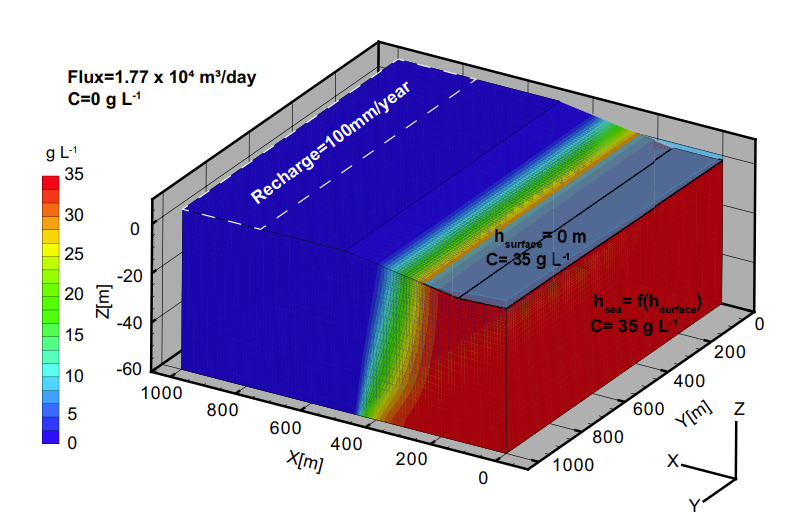
Fig. 3. Schematic diagram of model domains and boundary conditions. This conceptual model represents the base case that features a linear coastline.
This publication co-authored by Xuan Yu, Lanxuan He, Rongjiang Yao, Zexuan Xu, George Kourakos, Jie Yang, and Franklin W. Schwartz, which investigates how shoreline curvature influences saltwater circulation, freshwater–saltwater mixing, and submarine groundwater discharge (SGD) in coastal aquifers. This study leverages HydroGeoSphere (HGS) to perform fully three-dimensional, variable-density groundwater flow and salt transport simulations, addressing long-standing limitations of two-dimensional coastal aquifer models that neglect along-shore and lateral flow processes.
Traditional models of coastal saltwater intrusion often rely on two-dimensional cross-sections, implicitly assuming straight shorelines and groundwater flow perpendicular to the coast. While computationally efficient, these approaches overlook the three-dimensional complexity introduced by realistic shoreline geometry. By using HGS to simulate coupled surface–subsurface flow and advective–dispersive salt transport in three dimensions, this research explicitly captures lateral groundwater movement and density-driven circulation associated with concave and convex coastlines.

Fig. 7. Example of simulated salinity distribution and mixing zone in concave and convex. Area between 10% and 90% salinity contours (white) is defined as the mixing zone. The mixing zone area is given at the left of each cross section.
The study applied HGS to a series of idealized coastal aquifer models representing common concave and convex shoreline curvatures observed along the coast of China. Results showed that shoreline curvature generated significant lateral groundwater velocities— accounting for approximately 2 % to 12 % of longitudinal flow— and produced nonlinear responses in saltwater circulation. Both the extent and spatial distribution of the freshwater–saltwater mixing zone varied systematically with curvature, driven by convergent flow along concave shorelines and divergent flow along convex shorelines.
Key findings demonstrated that shoreline curvature also altered the travel times and pathways of groundwater contributing to SGD. Increased lateral circulation lengthened the residence time of fresh groundwater prior to discharge while having a more limited effect on saline SGD travel times. These effects cannot be resolved using cross-sectional models and highlight the importance of three-dimensional flow representation when characterizing mixing processes and discharge dynamics in coastal settings.
HydroGeoSphere proved essential in enabling this work due to its ability to simulate fully coupled, variably saturated, variable-density flow and salt transport within a single, physics-based framework. By resolving groundwater flow in all spatial directions and linking it directly to solute transport and particle tracking, HGS allowed the authors to quantify how subtle changes in shoreline geometry can fundamentally reshape coastal groundwater circulation.
This research provides critical insights for coastal hydrogeology and groundwater management, showing that advanced, physics-based modelling approaches like HydroGeoSphere are necessary to accurately assess saltwater intrusion, mixing zone dynamics, and submarine groundwater discharge. By demonstrating the non-negligible influence of shoreline curvature, the study paves the way for more reliable evaluations of freshwater availability, biogeochemical exchange, and coastal aquifer vulnerability under changing environmental conditions.
Abstract:
In coastal lowland and plains, where dense populations and extensive agriculture thrive, fresh water is a necessity. Management of coastal groundwater requires quantitative models of groundwater flow and transport to reveal salinity distributions and submarine groundwater discharge (SGD). Historically, computational burdens in modeling coastal groundwater necessitated the use of 2-D models along cross-sections. However, a variety of different features add fully three-dimensional complexity to near-shore groundwater flow and complex patterns of saline-fresh groundwater mixing. Shoreline geometry is one such feature which has not been systematically assessed. We modeled mixing processes between freshwater and saltwater in three dimensions using the coupled surface/subsurface flow and transport code HydroGeoSphere. Various concave and convex coastlines were constructed with geomorphological features characteristic of those in China. Our simulation suggested that the lateral groundwater flow can cause significant velocity perpendicular to the plane of the cross-sections, accounting for from 2% to 12% of longitudinal velocity. The lateral velocity component of groundwater increases with shoreline curvature, causing nonlinear responses of lateral saltwater circulation. The mixing zone and SGD change as a function of coastline curvature, which depends mainly on the magnitudes of convergent/divergent flow. In addition, shoreline curvature increases the mean travel time of fresh SGD, while a limited impact on the travel time of saline SGD is found. Our results highlight the nonnegligible influence of coastline geometry on lateral groundwater flow, freshwater-saltwater mixing, and SGD characteristics in commonly concave and convex shorelines. This study has important implications for management of groundwater resources, comprehension of biogeochemical processes along the coastal lowlands and plains.