
HGS RESEARCH HIGHLIGHT – Stable Water Isotopes Improve Calibration and Flow path Identification in Integrated Hydrological Model

Nimr, O. A., Marttila, H., Autio, A., & Ala-aho, P. (2025). Stable Water Isotopes Improve Calibration and Flow path Identification in Integrated Hydrological Models. Wiley. https://doi.org/10.22541/essoar.175578728.83361992/v1
“We applied a spatially uniform, time-varying nodal flux boundary condition, directly inputting daily measured meltwater flux at the model surface. This approach removes the need for the HGS solver to estimate snowmelt, reducing input uncertainty. The meltwater flux was based on the average daily outflow from the snowpack measured from the 11 lysimeters, coinciding with isotope sampling.”
This publication co-authored by Omar Ashraf Nimr, Hannu Marttila, Anna Autio, and Pertti Ala-Aho, investigates how stable water isotopes can improve calibration, uncertainty reduction, and flow path identification in fully integrated surface–subsurface hydrological models. This study leverages HydroGeoSphere (HGS) to explicitly simulate both hydrologic processes and isotope transport, addressing long-standing challenges related to equifinality and internal process realism in groundwater–surface water modelling.
“Stable water isotope transport simulations were conducted by integrating a solute transport model to the flow model, in HydroGeoSphere (HGS).”
Traditional hydrological model calibration typically relies on hydrometric observations such as streamflow and groundwater levels. While these metrics can be matched by multiple parameter sets, they often fail to constrain internal storage–flux partitioning and flow pathways. By contrast, stable water isotopes (δ¹⁸O) carry information about water sources, mixing, and travel times that hydrometric data alone cannot reveal. In this study, isotopes were incorporated directly into HGS through explicit advection–dispersion transport, allowing isotopic signals to evolve consistently with simulated flow dynamics rather than being used only as diagnostic or conceptual constraints.
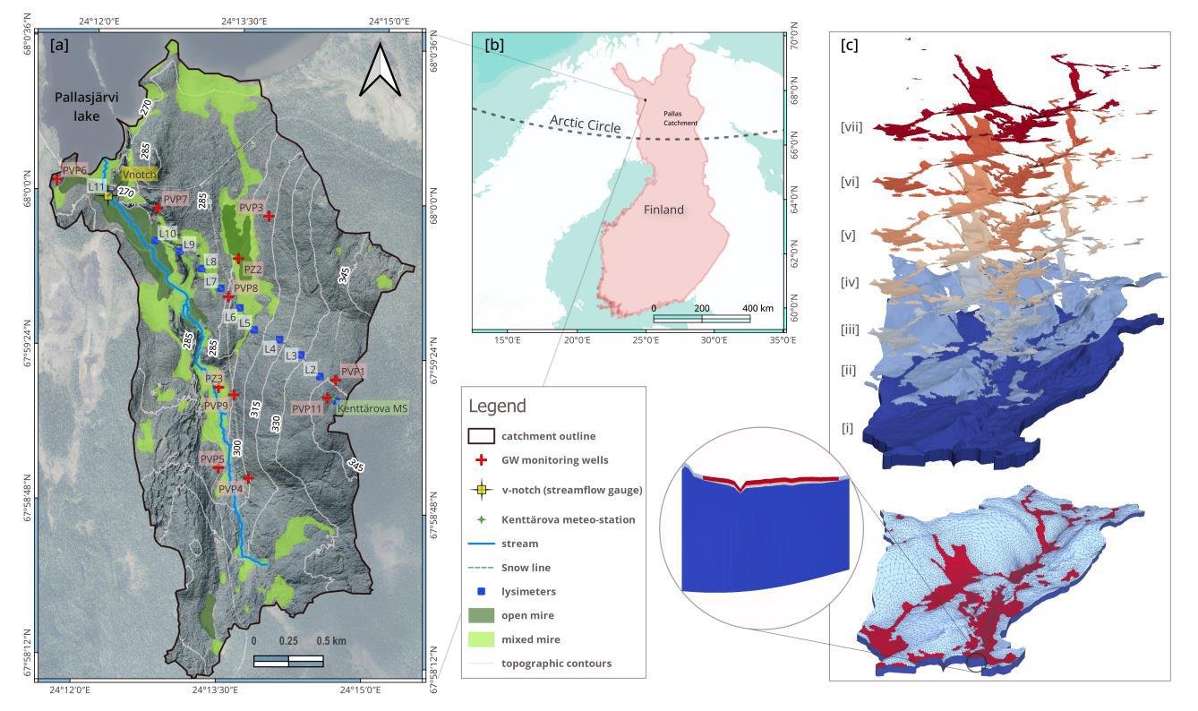
Fig. 1. (a) Map of the Pallaslompolo catchment areal extent as modeled in this study, displaying groundwater monitoring locations, the lysimeters network along the snow survey line, the stream gauge and sampling site, and the regional landcover distribution; (b) Inset map; geographic location of the Pallaslompolo catchment in Finland’s subarctic, within the circumpolar Arctic; (c) Three-dimensional (3-D) model mesh and subsurface domain layers, comprising (i) bottom glacial till, (ii) top glacial till, and (iii–vii) five peat layers arranged from deep to superficial, with a cross-sectional view at the catchment outlet illustrating the stratigraphic sequence used in the simulations.
The study applied this approach to the snow-dominated Pallaslompolo catchment in sub-arctic Finland, using high-temporal-resolution isotope data from snowmelt and streamflow. Multiple calibration strategies were tested using HGS coupled with PEST++, targeting hydrometric data alone, isotopic data alone, and combined datasets. Results showed that while all setups reproduced streamflow and groundwater levels reasonably well, they diverged substantially in internal storage partitioning and recharge behavior. Models calibrated with isotopic information exhibited greater deep percolation and groundwater recharge, while hydrometric-only calibration retained more water in the unsaturated zone.
Key findings demonstrated that combining hydrometric and isotopic targets produced the narrowest parameter uncertainty and the most physically consistent internal dynamics. Isotope-only calibration yielded wider uncertainty bounds but preserved similar dominant flow paths, highlighting the strong diagnostic power of isotopes. In contrast, hydrometric-only calibration produced intermediate uncertainty that masked potentially misleading internal process representations. These results underscore the importance of isotopes for revealing subsurface flow paths and storage–flux interactions that are otherwise undetectable.
HydroGeoSphere proved essential in enabling this work due to its ability to simulate fully coupled surface–subsurface flow together with explicit isotope transport in a three-dimensional, physics-based framework. By resolving both hydrometric and isotopic dynamics within a single model, HGS allowed the researchers to link calibration choices directly to changes in recharge, mixing, and internal flow partitioning, providing a robust basis for uncertainty analysis and process interpretation.
This research provides critical insights for integrated hydrological modelling, demonstrating that advanced, physics-based tools like HydroGeoSphere are key to overcoming equifinality and improving confidence in model realism. By integrating stable water isotopes into fully distributed GW–SW simulations, the study paves the way for more reliable calibration strategies and deeper understanding of catchment-scale hydrological processes under changing climatic conditions.
Abstract:
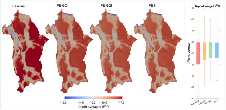
Fig. 10. Depth-averaged δ¹⁸O maps (3D porous media domain collapsed into 2D) and boxplots from four calibration setups (Baseline, PE-GQ, PE-GQI, PE-I) during the early recession phase (on day June 15th, 2020). The left panel shows spatial maps of δ¹⁸O, with hotter (red tone) indicates depleted (more negative) isotope values, cooler (blue tone) indicates enriched (less negative) values. The right panel displays boxplots summarizing the spatial distribution of δ¹⁸O values across the catchment for each setup
Hydrological models often exhibit equifinality, where different parameter sets produce similar hydrometric outputs but alter internal catchment processes and partitioning. Incorporating new information amongst calibration targets helps narrow the range of viable models. While stable water isotopes have gained traction in rainfall-runoff model calibration, their application in integrated Darcy-Richards groundwater–surface water (GW-SW) models remains limited. We test how combining hydrometric (streamflow Q, groundwater levels GWL) and isotopic (stream δ¹⁸O) targets affects parameter sensitivity, guides calibration, and informs flow path inference. Using the fully integrated HydroGeoSphere model for the sub-arctic Pallas catchment, we applied a workflow combining global sensitivity analysis, uncertainty and automated parameter estimation with PEST++ across multiple target combinations. Sensitivity analysis showed δ¹⁸O alone produced patterns similar to those from combined targets (Q + GWL + δ¹⁸O), suggesting isotopes can independently constrain key system parameters. All calibration setups performed comparably for hydrometric outputs but diverged in internal storages and partitioning. Combining isotopic and hydrometric targets led to greater recharge via rapid deep percolation and yielded the narrowest parameter uncertainty. δ¹⁸O-only calibration yielded the widest uncertainty bounds yet reproduced similar core internal dynamics, underscoring its standalone diagnostic power. Hydrometric-only calibration inferred minimal recharge, increased soil storage, and produced -potentially misleading- intermediate uncertainty. These findings demonstrate that δ¹⁸O reveals internal catchment dynamics undetected by hydrometric data alone in GW-SW modeling. Although isotopes cannot fully resolve equifinality, their integration with hydrometric targets improves parameter identifiability and model realism. We therefore advocate wider adoption of stable isotopes in integrated GW–SW modeling.