

HGS RESEARCH HIGHLIGHT – Saltwater Intrusion Into a Confined Island Aquifer Driven by Erosion, Changing Recharge, Sea-Level Rise, and Coastal Flooding
This research sheds light on the complex interactions between storm surges, reduced recharge, high erosion rates, and sea-level rise on the hydrological balance of Prince Edward Island. By leveraging the advanced capabilities of HGS, the researchers were able to test impact that climate change and future trends in coastal hydrology will have on the islands groundwater quality and the movement on the saltwater wedge underlying PEI.
HGS RESEARCH HIGHLIGHT – Simulating the recession dynamics of Arctic catchments in the context of a thawing permafrost
In a recent study, researchers have made significant strides in understanding how climate warming is altering the Arctic's hydrological dynamics. The study delves into the complex relationship between permafrost thaw and groundwater flow. Traditionally, Arctic hydrology has been conceptualized as a local system, confined by the frozen ground. However, as the climate warms, permafrost begins to thaw, transitioning this system into a more interconnected network of regional aquifers. This transformation is crucial, as it alters the fundamental dynamics of water movement and storage in the Arctic.

HGS RESEARCH HIGHLIGHT – Understanding the vulnerability of surface–groundwater interactions to climate change: insights from a Bavarian Forest headwater catchment
This study used HydroGeoSphere to evaluate the impact of climate change on streamflow and water availability within a small forested catchment in South-East Germany. Climate forecasts in the region predict a significant decrease in precipitation over the coming decades. Based on integrated hydrologic modelling of the catchment, this forecasted decline in precipitation combined with a relatively steady rate of evapotranspiration (compared to the historical period) will result in prolonged drought conditions, which in turn will result in declining groundwater levels, decreased baseflow to the upstream reaches of the stream network.

"Using Wetlands to Flatten the Hydrograph" - Webinar
We were so pleased to see a presentation featuring HydroGeoSphere at this year's Latornell Conservation Symposium. The presentation (“Using Wetlands to “Flatten the Hydrograph”) was delivered by representatives from Ducks Unlimited Canada (DUC), and focused on a recent collaboration between DUC, Ontario Power Generation (OPG) and Aquanty. At the center of the project is an advanced integrated hydrologic model of the Dog Lake watershed in Northern Ontario.

Manitoba Cooperator - Field-level water forecasts: There’s an app for that
The Manitoba Cooperator has written an excellent article (with comments from Dr. Steve Frey, Aquanty’s Director of Research Services) which reviews some of the new technology driven initiatives to manage water resources throughout Manitoba, with a specific focus on the newly developed MFGA Aquanty Forecasting Tool - a real-time hydrologic forecasting system for decision-support around water movement, soil health, climate risk assessment & mitigation in the Assiniboine River Basin and Pembina River watersheds.

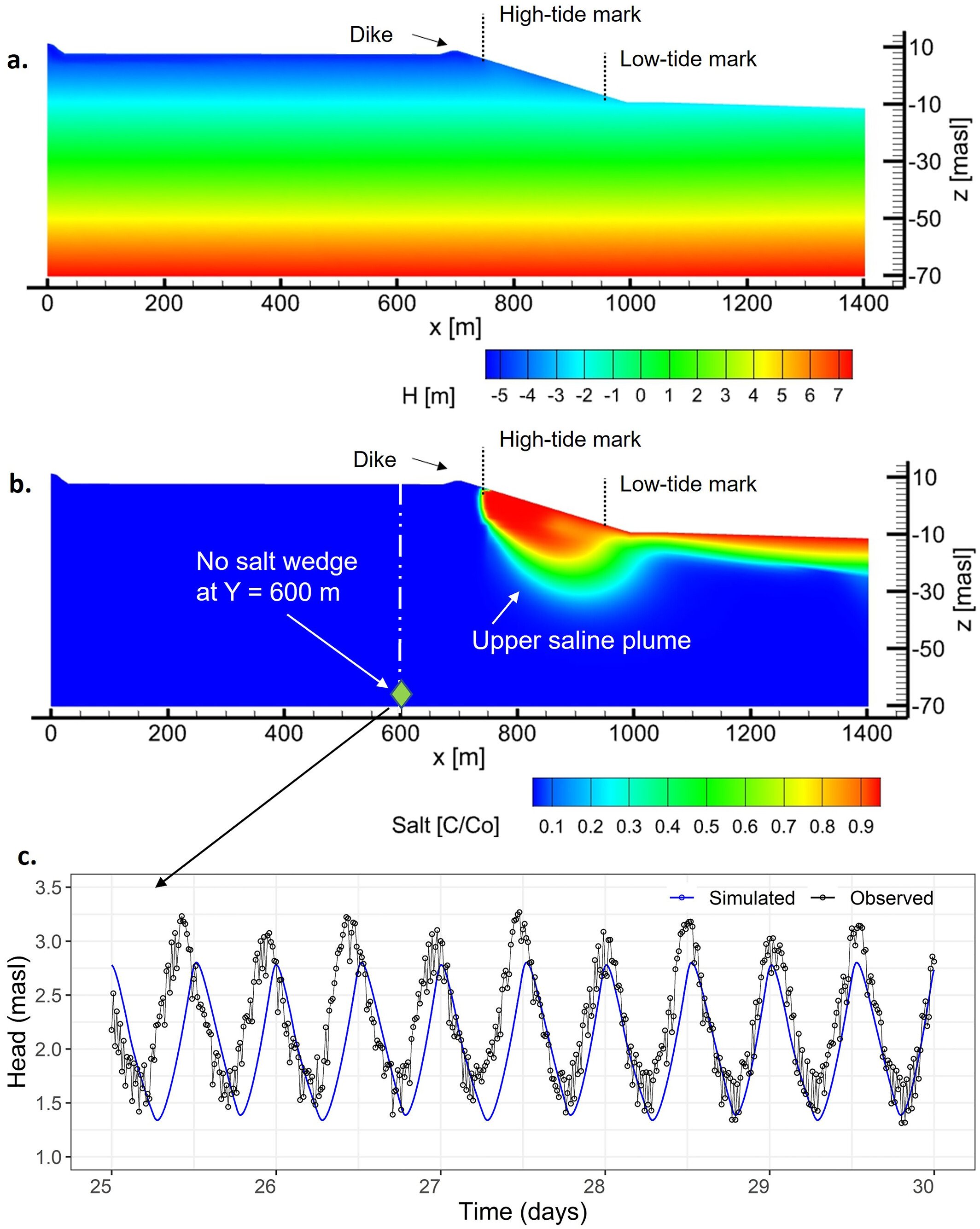
HGS RESEARCH HIGHLIGHT - Mega-Tidal and Surface Flooding Controls on Coastal Groundwater and Saltwater Intrusion Within Agricultural Dikelands
The study highlighted here makes full use of the density dependent flow modelling capabilities of HydroGeoSphere to investigate the impacts of climate change on groundwater-ocean interactions, and how sea-level rise, tides and storm-surges impact the long-term position of an upper saline plume in a coastal agricultural dikeland in Nova Scotia, Canada.

HGS RESEARCH HIGHLIGHT – Groundwater flow reversal between small water bodies and their adjoining aquifers: A numerical experiment
This recent study uses HydroGeoSphere to investigate groundwater-surface water interactions within “kettle holes” - post glacial landscape features prevalent across Northern Europe and Northern America. These kettle holes are quite similar to lakes, but their smaller size makes them prone to drying out, which results in very dynamic and variable groundwater-surface water interactions, sometimes being subject to groundwater flow reversal between a kettle hole and the adjacent aquifer.