

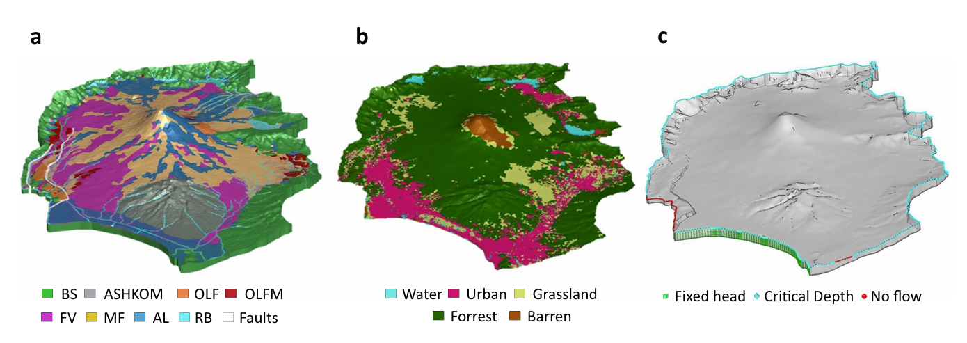
HGS RESEARCH HIGHLIGHT – Modeling a geologically complex volcanic watershed for integrated water resources management in Mt. Fuji, Japan
This publication presents a three-dimensional geological and integrated hydrological modelling dataset developed for the Mt. Fuji volcanic watershed in Japan. This study leverages HydroGeoSphere (HGS) to simulate coupled surface–subsurface flow and transport processes in a geologically complex volcanic catchment, addressing long-standing challenges in representing groundwater flow pathways and hydrologic interactions in structurally heterogeneous mountain environments. The resulting dataset provides a physically consistent modelling framework to support interdisciplinary water resources research and scenario-based hydrologic simulations.
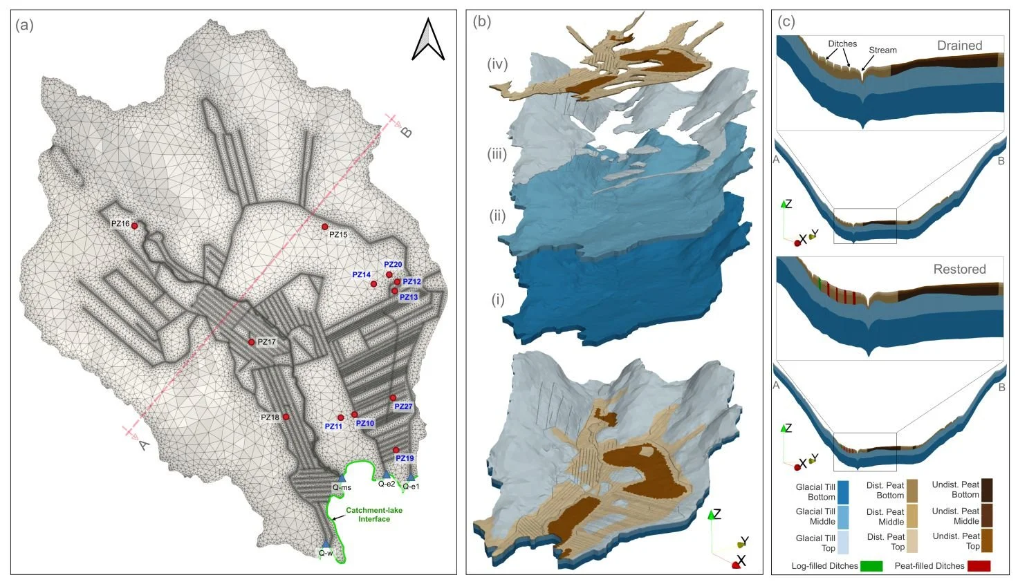
HGS RESEARCH HIGHLIGHT – How Does Rewetting Propagate Through Restored Peatlands? An Integrated Surface–subsurface Modelling Analysis of Water–table Dynamics
We’re pleased to highlight this publication, which investigates how peatland restoration alters groundwater table dynamics across drained boreal peatlands using fully integrated hydrologic modelling. This study leverages HydroGeoSphere (HGS) to simulate coupled surface–subsurface flow processes and evaluate spatial patterns of groundwater response following ditch blocking and rewetting interventions, addressing long-standing challenges in predicting restoration outcomes across heterogeneous peatland landscapes.

HGS RESEARCH HIGHLIGHT – External and internal drivers behind the formation, vegetation succession, and carbon balance of a subarctic fen margin
In this research publication, researchers investigated the formation, vegetation succession, and carbon balance of peatland margins in Finnish Lapland. This study leverages HydroGeoSphere (HGS) alongside paleoecological records and remote sensing to address long-standing challenges in understanding how new peatland areas initiate, expand, and influence climate through carbon cycling.

Staff Research Highlight - Spatiotemporal estimation of groundwater and surface water conditions by integrating deep learning and physics-based watershed models
We’re pleased to highlight this publication, co-authored by Aquanty’s senior scientist, Hyoun-Tae Hwang, which focuses on the integration of deep learning (DL) models with physics-based hydrological models to enhance the efficiency of estimating spatiotemporal groundwater and surface water conditions.
Staff Research Highlight - Effects of soil heterogeneity and preferential flow on the water flow and isotope transport in an experimental hillslope
We’re pleased to highlight this publication, co-authored by Aquanty’s senior scientist, Hyoun-Tae Hwang, which examines the water sources and threshold behaviours of streamflow generation in a mountain headwater catchment.
Staff Research Highlight - Assessment of hydraulic and thermal properties of the Antarctic active layer: Insights from laboratory column experiments and inverse modelling
We’re pleased to highlight this publication, co-authored by Aquanty’s senior scientist, Hyoun-Tae Hwang, which investigates the hydraulic and thermal properties of the Antarctic active layer using laboratory column experiments and HydroGeoSphere (HGS) for inverse modeling.
Staff Research Highlight - Water sources and threshold behaviors of streamflow generation in a mountain headwater catchment
We’re pleased to highlight this publication, co-authored by Aquanty’s senior scientist, Hyoun-Tae Hwang, which examines the water sources and threshold behaviours of streamflow generation in a mountain headwater catchment.
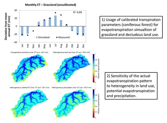
HGS RESEARCH HIGHLIGHT – Using High-Resolution Data to Test Parameter Sensitivity of the Distributed Hydrological Model HydroGeoSphere
By integrating HydroGeoSphere in this study, the researchers demonstrate its versatility in accommodating high-resolution data and conducting sensitivity analyses across different spatial scales. Precipitation emerges as the most sensitive input data, significantly influencing total runoff and peak flow rates. Additionally, the study highlights the importance of spatially distributed land use parameterization in accurately simulating evapotranspiration components and patterns.

"Using Wetlands to Flatten the Hydrograph" - Webinar
We were so pleased to see a presentation featuring HydroGeoSphere at this year's Latornell Conservation Symposium. The presentation (“Using Wetlands to “Flatten the Hydrograph”) was delivered by representatives from Ducks Unlimited Canada (DUC), and focused on a recent collaboration between DUC, Ontario Power Generation (OPG) and Aquanty. At the center of the project is an advanced integrated hydrologic model of the Dog Lake watershed in Northern Ontario.

"Climate Change Impact Analysis using HydroGeoSphere" - Aquanty Webinar
As the relevant components of the global climate (e.g. temperature and precipitation patterns/intensity) drift further from historically reliable patterns, it becomes harder and harder to rely on these historical patterns as part of hydrologic studies. This is why HydroGeoSphere is an incredibly powerful tool for long-term climate change impact analyses of hydrologic systems.