
HGS RESEARCH HIGHLIGHT - Using water sources extent during inundation as a reliable predictor for vegetation zonation in a natural wetland floodplain
Berezowski, T., & Wassen, M. (2023). Using water sources extent during inundation as a reliable predictor for vegetation zonation in a natural wetland floodplain. Ecological Indicators, 154, 110854. https://doi.org/10.1016/j.ecolind.2023.110854
“The fraction of river flooding, ground-water discharge, snowmelt, and rainfall water volume in each model node was calculated based on the IHM output using the HMC method (Partington et al., 2011), which can be included in the HydroGeoSphere IHM. ”
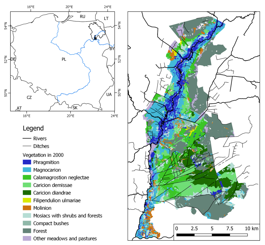
Figure 1. Lower Biebrza valley floodplain with the river network and vegetation in 2000 (Matuszkiewicz et al., 2000) (right panel). Location of the Biebrza catchment study area (black outline) and the floodplain (black patch) in Poland (left panel); the major rivers Wisla, Bug, Narew and Biebrza are indicated with blue lines. The legend concerns only the right panel. (For interpretation of the references to color in this figure legend, the reader is referred to the web version of this article.)
CLICK HERE TO READ THE ARTICLE.
We’re pleased to highlight this publication, co-authored by Tomasz Berezowski and Martin Wassen, which investigates how the extent of water sources during inundation can be used as reliable predictors of vegetation zonation in wetland floodplains. This study leverages HydroGeoSphere (HGS) together with the Hydraulic Mixing-Cell (HMC) method to address long-standing challenges in modelling vegetation dynamics by explicitly accounting for the spatial distribution of different water sources during floods.
Traditional floodplain vegetation models typically rely on local hydrological predictors such as water depth, inundation length, or groundwater table depth. While useful, these indicators often fail to represent the spatial effects of hydrological processes, particularly the mixing of water from multiple sources— river water, groundwater discharge, rainfall, and snowmelt— that drive ecological patterns. By combining HGS simulations with HMC analysis, this research provides not only standard hydrological metrics but also the areal extent of each water source within the inundation zone, creating more realistic predictors for vegetation modelling.
The study applied these predictors to the lower Biebrza River floodplain in northeastern Poland using vegetation maps from 1960, 1980, and 2000. A random forest model was trained to test five predictor scenarios, ranging from standard groundwater–surface water variables to source-based inundation extents. Results demonstrated that models using water source extent achieved the highest accuracy (82–83%), significantly outperforming those relying only on conventional predictors. Among all predictors, the fraction of river water in the inundation zone was found to be the single most important driver of vegetation distribution, particularly for highly productive reed and sedge communities.
Key findings showed that incorporating water-source-based predictors was crucial for capturing both past vegetation dynamics and projected changes under future climate scenarios (RCP 2.6, 4.5, and 8.5). While simpler models struggled to reproduce observed trends or predict future shifts, those using water source extents successfully identified transformations in sedge-moss and tall sedge communities, as well as changes in the extent of reed vegetation. This underscores the importance of representing the spatial footprint of hydrological processes in ecological models.

Figure 12. Degree of mixing between river water and floodplain water (i.e. groundwater discharge, rainfall, and snowmelt) simulated with the IHM and HGS methods during a spring flood event on 27th of March 2005 in a southern section of the floodplain. High d values indicate similar proportions of river and floodplain water, i.e. presence of mixing, and low values indicate that one source dominates over another, i.e. no mixing (see Table 1). The color of the velocity vectors is proportional to the water velocity (the length of each vector is the same).
HydroGeoSphere proved essential in enabling this work due to its ability to simulate coupled surface and subsurface flows and generate spatially distributed hydrological outputs. By integrating HGS with the HMC method, the study provided a more physically consistent and ecologically relevant framework for modelling floodplain vegetation. This approach demonstrates that explicitly accounting for water source extents can significantly improve predictive skill, offering a valuable decision-support tool for wetland management and climate change adaptation.
This research provides critical insights for ecohydrology and wetland conservation, showing that advanced, physics-based modelling approaches like HGS can bridge the gap between hydrological complexity and ecological processes. By embracing water source extent as a key predictor, the study paves the way for more accurate and sustainable management strategies in floodplain ecosystems.
Abstract:
Distinctive zones of inundation water during floods were shown to originate from different sources in some major floodplains around the world. Recent research showed that the zonation of water in rivers and floodplains is related to vegetation patterns. In spite of this, water source zones were not used for vegetation modeling due to difficulties in their delineation. In this study, we used simulation results of a fully-coupled groundwater-surface water integrated hydrological model (IHM) HydroGeoSphere and the Hydraulic Mixing-Cell method to provide standard hydrological predictors (e.g. water depth, inundation length, groundwater depth, exchange flux) and the extent of inundation zones having a certain water source (discharged groundwater, river, rainfall, and snowmelt). These variables were used to train a vegetation model for the lower Biebrza floodplain (about 290 km2) using vegetation maps from 1960, 1980, and 2000. We used a one-at-a-time (OAT) approach, where each map was validated based on a model trained on the remaining two maps to obtain realistic error estimates. We also used a fractional approach in which a fraction of each map was used for training and validation. The single model from the fractional approach was used to assess the importance of predictors and to predict vegetation for the 20th century and for the 21st century using IHM simulation forced by the Twentieth Century Reanalysis data and EURO-CORDEX RCP 2.6, 4.5, and 8.5 model ensembles. The model which used both water sources extent and standard predictors performed the best overall and was sensitive to the future trends. The extent of river water within the inundation area was by far the most important vegetation predictor. The models that neither used the water sources extent predictors nor the exchange flux were not able to predict the trends of areas covered by certain vegetation types under future climate. The advantage of the water sources extent predictors was their ability to represent the spatial effect of local hydrological phenomena. This was not possible with the standard predictors, because they show only the source of the phenomena (e.g. groundwater discharge zone), but do not indicate the actual area affected by its physical and chemical properties, which is more relevant for vegetation development. Our results highlight the relevance of using water extent predictors due to their ability to explain spatiotemporal ecological processes, such as vegetation development. We suggest to use water extent predictors in modelling for developing more accurate decision support for wetland floodplains.