
HGS RESEARCH HIGHLIGHT – How Does Rewetting Propagate Through Restored Peatlands? An Integrated Surface–subsurface Modelling Analysis of Water–table Dynamics

Nimr, O. A., Marttila, H., Batelaan, O., Partington, D., & Ala-Aho, P. (2026). How Does Rewetting Propagate Through Restored Peatlands? An Integrated Surface–subsurface Modelling Analysis of Water–table Dynamics. Elsevier BV. https://doi.org/10.2139/ssrn.6265631
“To address these knowledge gaps, we developed and calibrated fully integrated, physically based surface subsurface hydrological models of a boreal fen-type peatland, explicitly representing both drained and restored states, using HydroGeoSphere.”
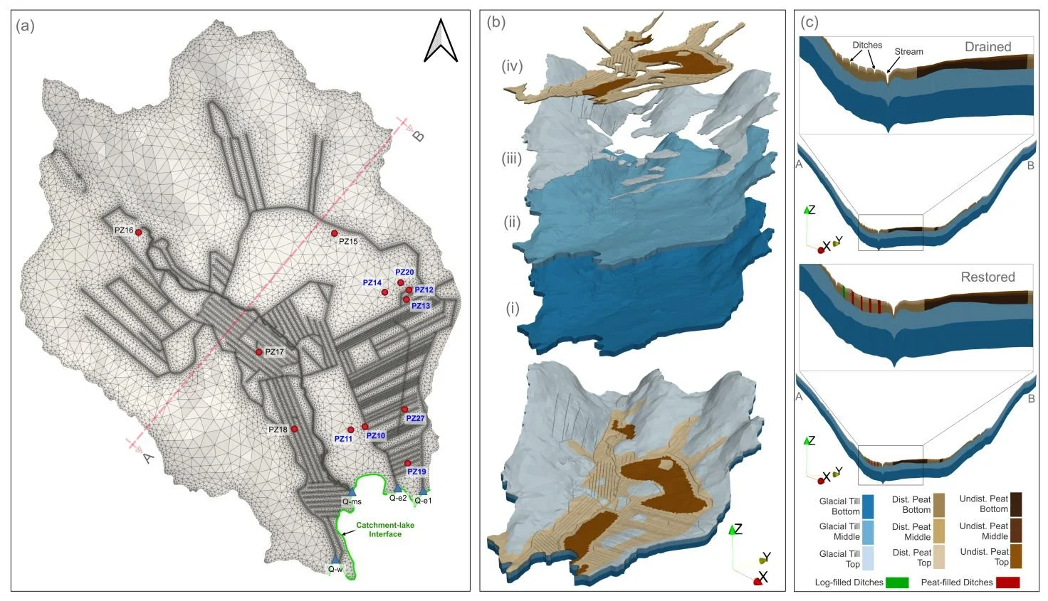
Fig. 2. Three-dimensional HydroGeoSphere model structure for the Matorova catchment. (a) Two-dimensional computational mesh of the model domain showing catchment stream outlets and the monitoring network; wells installed pre-restoration are labeled in blue, and wells installed post-restoration are labeled in black. (b) model stratigraphy shown as a vertically stacked three-dimensional conceptualization: the assembled 3D catchment domain at the base, overlain by bottom (i), middle (ii), and upper (iii) till layers, and capped by layer (iv), which combines three vertical peat sublayers into a single peat unit. (c) Cross-section A–B through the model domain for both drained and restored setups, showing the discretized stratigraphy and assigned material defintions.
We’re pleased to highlight this publication, which investigates how peatland restoration alters groundwater table dynamics across drained boreal peatlands using fully integrated hydrologic modelling. This study leverages HydroGeoSphere (HGS) to simulate coupled surface–subsurface flow processes and evaluate spatial patterns of groundwater response following ditch blocking and rewetting interventions, addressing long-standing challenges in predicting restoration outcomes across heterogeneous peatland landscapes.
Peatland restoration assessments often rely on localized monitoring wells or simplified hydrologic indicators that cannot fully capture catchment-scale groundwater responses. While these approaches provide useful point-scale insights, they frequently overlook the spatial variability of restoration impacts controlled by peat thickness, geomorphology, and subsurface stratigraphy. By applying a three-dimensional HydroGeoSphere model forced with daily climatic inputs— including rainfall, snowmelt, and evapotranspiration— this research provides a physically consistent framework for simulating groundwater table evolution across both drained and restored peatland configurations.
The study applied the HGS model to the Matorovasuo peatland catchment using calibrated simulations constrained by groundwater observations from multiple monitoring wells and eddy covariance measurements of evapotranspiration. Results showed that restoration shifted catchment hydrology from an efficient drainage-dominated system toward a retention-dominated regime, producing spatially variable rises in groundwater table depth that depended strongly on peat thickness, slope, and distance from the peat–mineral interface. Simulated groundwater responses increased toward peatland interiors and stabilized beyond approximately 150 m from peat margins, highlighting the importance of geomorphological controls on restoration effectiveness.
“Climatic forcing was applied at a daily time step, and spatially distributed outputs for all relevant HydroGeoSphere flow variables, primarily including groundwater elevation, water-table depth, and surface saturation, were generated at daily intervals. Initial conditions for these simulations were obtained from approximately two-year spin-up runs (January 2021 to October 2022), each initialized from steady-state conditions.”
Key findings demonstrated that restoration-induced groundwater recovery is highly heterogeneous across peatland landscapes and cannot be reliably inferred from local measurements alone. Instead, spatially distributed simulations revealed systematic relationships between groundwater table rise and peatland structural properties, providing new insight into how restoration strategies influence hydrologic functioning at the catchment scale.
HydroGeoSphere proved essential in enabling this work due to its ability to simulate fully integrated groundwater–surface water interactions within a three-dimensional stratified peatland system while incorporating climate-driven boundary conditions and spatially distributed evapotranspiration processes. This capability allowed the researchers to evaluate restoration impacts across multiple land-cover types and hydrologic zones within a single physically based modelling framework .
This research provides critical insights for peatland restoration planning and climate mitigation strategies, demonstrating that advanced modelling approaches like HydroGeoSphere can improve predictions of groundwater recovery following rewetting interventions. By linking restoration outcomes to peatland geomorphology and hydrologic structure, the study supports more effective management of carbon-rich peatland ecosystems under changing environmental conditions.
Abstract:
Peatland restoration, through drainage suppression, is widely implemented to recover ecological function, yet the driving hydrological mechanisms controlling groundwater responses across spatial and temporal scales remain poorly quantified, limiting defensible restoration plans. Here, we use calibrated, fully integrated 3D physics-based modeling to explicitly resolve how rewetting interventions, including ditch infilling and damming, restructure catchment-scale groundwater dynamics across a boreal fen. Simulated restoration actions elevated water tables by ~23 cm, with comparable gains in nominally undisturbed areas, demonstrating far-field impacts of drainage legacy and the re-establishment of lateral hydrological connectivity as a restoration outcome. Variogram analysis revealed that hundreds of meters of previously fragmented, drainage-controlled peatlands were transformed into hydraulically connected systems, enhancing spatial correlation and damping extreme drawdowns. Additionally, findings revealed that lateral propagation of water table recovery depended on restoration structure type and its hydraulic properties, with low-permeability peat infillings producing strong local responses with steep exponential decay (~70% within ~40 m), whereas dams generated broader plateauing effects (~100 m radius). Geomorphic context further modulated outcomes, with water table recovery following exponential growth away from peat–mineral margins, and intermediate-thickness peatlands defining a tipping-point regime that maximizes recovery magnitude and variability. Seasonal dynamics amplified restoration efficiency, with wet periods nearly doubling water-table rise relative to dry winters, yet elevated efficiency persisted during dry intervals between spring melts and autumn rains. Collectively, these findings reveal how restoration effects propagate laterally, interact with seasonal hydroclimatic forcing, and are shaped by geomorphic context, providing a transferable, mechanistic framework for prioritizing and designing restoration plans that maximize peatland hydrological recovery.