

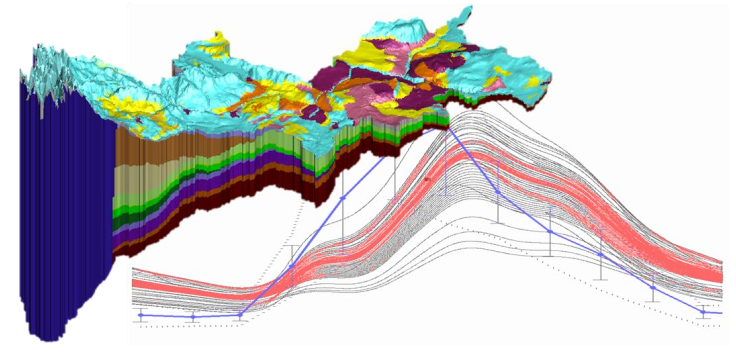

HGS RESEARCH HIGHLIGHT – Simulating fully-integrated hydrological dynamics in complex Alpine headwaters: potential and challenges
Alpine areas are inherently difficult to model, with large elevation gradients (steep, rugged terrain), complex geology and highly variable weather conditions, but nevertheless a satisfactory model calibration was achieved. The model incorporated fully integrated surface/groundwater flow, evapotranspiration processes, and dynamic snowmelt (using an energy balance-based representation of snow processes), all underpinned by a detailed 3D geological model.
HGS RESEARCH HIGHLIGHT – Characterizing the effects of dry antecedent soil moisture conditions, channel transmission losses, and variable precipitation on peak flow scaling
While the historic flooding in British Columbia this month can obviously be attributed to extreme rainfall, it’s also believed that the extreme heat of the summer months made soils less permeable. This means that rain is more likely to run off the land rather than being absorbed, resulting in flash floods and landslides. In this case the diminished permeability can likely be attributed to soil ‘crusting’ (wildfires disperse waxy compounds which coat soil minerals and make the top layer of soil hydrophobic). But extremely dry conditions are also known to reduce the permeability of soils, even without the compounded effects of wildfires. A recent study by researchers at HDR Engineering, Berkshire Hathaway Specialty Insurance, Iowa State University and The University of Iowa investigates this very phenomenon.
"Athabasca River Basin High-Res Modelling of the Impact of Climate Change" - Webinar hosted by COSIA
On September 16th, 2021 Aquanty's senior scientist Hyoun-Tae Hwang delivered a webinar discussing our recent work in modelling the impacts of climate change in the Athabasca River Basin using HydroGeoSphere. We would like to thank Canada's Oil Sands Innovation Alliance (COSIA) for the opportunity to present this most recent research, which follows on several years of partnerships to model the ARB in high-resolution using HydroGeoSphere, Aquanty’s cutting edge integrated hydrologic modeling platform.
HGS RESEARCH HIGHLIGHT – Integrated modelling to assess climate change impacts on groundwater and surface water in the Great Lakes Basin using diverse climate forcing
HydroGeoSphere is an excellent tool for evaluating climate change impacts to integrated hydrologic systems, since HGS can be effectively coupled with climate forecasting simulators like the Weather Research and Forecasting (WRF) model, the Community Climate System Model (CCSM) and the Canadian Regional Climate Model (CRCM). HydroGeoSphere accounts for water dynamics in the atmosphere, ground surface and subsurface in a seamless manner and thus is the best modeling tool for evaluating the impact and risk associated with climate change on water resources.
HGS RESEARCH HIGHLIGHT - Simulating Climate Change Impacts on Surface Water Resources within a Lake Affected Region using Regional Climate Projections
This study aims to assess the impact of climate change on water resources in a large watershed within the Laurentian Great Lakes region, using the fully‐integrated surface‐subsurface model HydroGeoSphere. The hydrologic model is forced with an ensemble of high‐resolution climate projections from the Weather Research and Forecasting model (WRF). The latter has been extended with an interactive lake model (FLake) to capture the effect of the Great Lakes on the regional climate. The WRF ensemble encompasses two different moist physics configurations at resolutions of 90km, 30km, and 10km, as well as four different initial and boundary conditions, so as to control for natural climate variability. The integrated hydrologic model is run with a representative seasonal cycle, which effectively controls natural climate variability, while remaining computationally tractable with a large integrated model.